The 50 Greatest Walks of the World - Barry Stone (2016)
23. ISLE OF MAN COASTAL PATH
Isle of Man
Distance: 153 km
Grade: Strenuous
Time: 5-7 days
Created to celebrate the Isle of Man’s Heritage Year celebrations in 1986, the 153-km-long Isle of Man Coastal Path - the Raad ny Foillan, the ‘Way of the Gull’ - encircles the entire Manx coast, from the extensive dune systems, glens and shingle beaches of the north and 600-ft-high cliffs in the west, to the rugged cliffs and moorlands of the south, and leads towards Cashtal yn Ard (Castle of the Heights) in the east, the largest Neolithic tomb of its kind in the British Isles. When the trail is forced to take to the island’s roads they are as much a blessing as a curse, with little traffic to interfere with the sensory delights around you. You are never far from the ocean, of course, never far from the ‘cry of the gull’. And never far, also, from reminders that you are in a different world - the world of the ‘Manx’ - the result of hundreds of years of Celtic/Norse migration followed by Irish influences which eventually gave birth to the Manx language - Manx Gaelic - which still undergoes its periodic revivals. Envelopes won’t get off the island unless a Manx stamp is affixed to it, and the Manx pound is the island’s currency. It is a proud, independent heritage you cannot help but be aware of as you walk a coastline that is treated as a prized asset by the island’s residents.
Here you can be in no doubt you are walking along the same high coastal ground where the first hunter gatherers of the Middle Stone Age would have lived in tiny huts, and who would have looked across at the same crumbling cliffs of Orrisdale Head north of Peel as you do. Neolithic and Bronze Age arrivals brought farming, pottery, and a scattering of megalithic monuments such as King Orry’s grave at Laxey. There is no evidence the Romans ever came here, but the Vikings and Druids did, and so did Pictish seafarers, who chose to settle here and then became farmers - when they weren’t conducting raids on Roman Britain as the dreaded ‘painted men’.
ISLE OF MAN COASTAL PATH
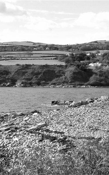
Photo: Badgernet
The Isle of Man Coastal Path starts and finishes at the Millennium Bridge in the island’s capital of Douglas, population 30,000 - a far cry from the tiny settlement of 1511 when a mere thirteen households were documented north of the harbour. It is easily walked in sections, if that is all you have time to do, and each place name that indicates a sectional starting point is well serviced by the island’s network of buses. But to walk the entire circuit takes only a week at most, which makes it a very real consideration if one wants to ‘complete’ a trail rather than attempting only part of the usual long distance footpaths and National Trail options.
An eclectic mix of views and experiences await you on this varied trail. The path skirts the boundary of Ronaldsway Airport near Derbyhaven and passes over the site of the 1275 battle on which the Manx kingdom lost its independence to the Scots for a hundred years until the English arrived and supplanted them. Between St Johns and Ramsey you’ll walk along the trackbed of the abandoned Manx Northern Railway, and there is a long and very pretty section of pebbly beach from Ramsey to Point of Ayre, the path’s northernmost point where you’ll find the Point of Ayre lighthouse, the island’s oldest lighthouse (1818) designed and built by Robert Stevenson, the grandfather of author Robert Louis Stevenson. On the east coast, while in Laxey be sure to detour to the famous Laxey waterwheel, the largest in existence, and also walk to Dhoon Glen, a gorgeous wooded glen just north of Laxey with steep inclines that will make you ‘work’ for the views!
If you want to make the most of your stay on the island there are three other marked trails worth considering: the half-day Heritage Trail (16 km, easy) inland from Douglas across to Peel following the old Douglas to Peel railway line; a full day’s hike along the Herring Trail (22.5 km, easy) from Peel inland via Glen Maye to Castletown in the south once used by the island’s fishermen; and the Millennium Way from Ramsey to Castletown running north-south down the island’s interior, a path once used by the Manx King, and first documented in the 13th-century Chronicles of the Kings of Mann. And that’s a lot of history for one very small island.