The 50 Greatest Walks of the World - Barry Stone (2016)
5. INCA TRAIL
Arequipa, Peru
Distance: 45 km
Grade: Moderate
Time: 4 days
This extraordinary trail, which routinely tops travellers’ lists as their most unforgettable adventure, begins two hours out of the Peruvian city of Cuzco, a city redesigned in the 15th century, prior to the arrival of the Spanish, over a pre-Inca settlement during the rule of Pachacuti, to become the capital of the Tawantinsuyu Inca Empire. With its harmonic blend of Incan and Spanish conquistador-era architecture Cuzco is worth exploring over two or three days, if only to assist in acclimatising to the high altitudes to come as you prepare yourself for your journey into the Sacred Valley and the magical ‘Lost City’ of Machu Picchu, perched as dramatically as any city or dwelling in the world is perched - on a narrow ridge between Machu Picchu Mountain and Huayna Mountain, 2,450 m above the Urubamba River below.
Day 1 begins at the Km 82 road marker a bus ride out of Cuzco at an elevation of 2,800 m on the banks of the Urubamba. From there you walk 14 km on a gentle ascent along the Cusichaca Valley that will take you past the pre-Inca semi-circle-shaped settlement of Patallaqta at the confluence of the Willkanuta and Kusichaka Rivers which you’ll see only from the trail as most tours don’t include a diversion to this interesting site that would have been home to over a thousand people at the height of the Inca Empire. From here the trail connects with the Mollepata Trail (3,000 m) at the village of Wayllapampa, the last inhabited village on the route and the point where many consider the ‘real’ trail begins. From here you turn westward and follow a tributary of the Kusichaka, at which point all animals and even metal-tipped trekking poles are left behind to prevent trail erosion. It’s worth pushing on to Ayapata Campground, because the second day is the longest and hardest, and camping a little ahead of other more frequented campgrounds provides a welcome head start.
On Day 2 the scenery becomes increasingly breathtaking as you climb the Llullucha Valley and make for the trail’s highest point at Warmi Wanusqa, ‘Dead Woman’s Pass’ (4,215 m). On the way you will pass groves of rare Polylepis trees, gnarled shrubs that belong to the rose family, which are wind-pollinated and endemic to the mid and high elevations of the tropical Andes, making it the world’s highest flowering genus - so not to be walked past as though they are mere shrubs! An expanse of treeless grasslands - the Puna - follows, and an open slope with in-your-face views of nearby mountain crags sees you on Dead Woman’s Pass with its sweeping views of the Huayanay Massif, before descending some 600 m on a steep gradient to Pakaymayu, and your camp for the night.
Early on Day 3 you climb again, this time on an ancient Inca stairway to the substantial remains of Runkuracay - either built as a lookout or perhaps as a tambo, a wayside stop for couriers complete with sleeping accommodation and stables for their horses. The trail leads on to its second pass at Abra de Runkuracay (3,500 m) and then descends into a valley with a small lake where the path changes from dirt to stone - the start of the very same route once trodden by the Incas themselves. Sayacmarca, a fort perched on a rocky spur overlooking the valley, is next, accessed via a narrow stone stairway with a steep drop-off on the right-hand side to the rocks below. Another descent follows, this time down to a causeway that may once have crossed a small lake, before climbing again and passing through a delightful piece of Inca engineering - an 8-m-long tunnel that was cut from a natural fissure in the rock and made big enough for the passage of men, animals and supplies.
INCA TRAIL
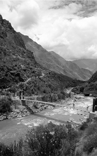
Photo: Colegota
Climbing still further you reach the third pass at Phuyupatamarca (Cloud-level Town), a place of ritual with a series of fountains and terraced baths - the higher baths reserved for use by Inca nobility, and the baths below for the lower classes who had to bathe in the nobility’s discarded waters. Below Phuyupatamarca the trail twists steeply down into genuine jungle on an irregular Inca staircase that provides views over the Willkanuta River as you descend (while listening for the sound of trains running along the valley floor!) to Winay Wayna (Forever Young), named after a local pink orchid. Winay Wayna’s marvellous collection of baths used for ritualistic cleansing and its array of agricultural terraces would make it worthy of a stop, even without its often overcrowded Trekkers’ Hostel, and it is the trail’s last official campsite.
Day 4 begins, and the start of the trail’s final section - 3 km of mercifully easy and flat ground ending in a short, steep staircase which delivers you to Intipunku, the famed Gateway of the Sun, through the rectangular doorway of which you can at last gaze upon the remains of Machu Picchu before starting on the short path down to the famed city, built as a royal retreat for the Inca emperor Pachacuti around 1450 only to be abandoned a century later during the Spanish conquest - and remaining hidden from the outside world until its rediscovery in 1911 by the American explorer and academic Hiram Bingham.
The trail to Machu Picchu can be hiked over as little as two days, or as many as five. The two-day option means taking a bus for a 2.5-hour ride to the village of Chachabamba at the Km 104 road marker, thus getting a significant jump on those who begin at the traditional Km 82 marker. A four-hour hike to Winay Wayna follows before continuing on to the Sun Gate for those unforgettable views over the city itself.