The 50 Greatest Walks of the World - Barry Stone (2016)
8. TROTTERNISH RIDGE
Isle of Skye, Scotland
Distance: 37 km
Grade: Moderate
Time: 2 days
A challenging trail on the largest and northernmost island of the Inner Hebrides, this walk along the Isle of Skye’s Trotternish Ridge begins in Flodigarry, a small settlement on the eastern side of the Trotternish Peninsula and continues south to The Storr, a craggy summit overlooking the Sound of Raasay. The trail runs through a landscape born of a series of landslips so massive it even has its own geological term - the Quiraing, Great Britain’s longest geological landslip. On the way the wealth of natural sights you’ll see as you clamber across this outlandish realm, this pulsating, living landscape, are predictably impressive: the pinnacle that is the Old Man of Storr high above Loch Leathan; the 37-m-high Needle; the pyramidal rocky peak called The Prison. And while you don’t need to know how all these landforms came to exist in order to appreciate their beauty, knowing precisely how this misshapen world got here will lift the experience of walking one of the nation’s most spectacular ridge walks still higher, maybe even into the realm of ‘life-changing’.
Looking at it all you inevitably wonder: ‘How did it happen?’ Like most good things: slowly. Sixty million years ago Jurassic sediments - sandstones and clays, though mostly shale - were laid down and later overlaid by dozens of thick Tertiary basalt lava flows. No longer able to bear the accumulated weight pressing down upon it, the sediments began to be turned sideways on a north-south trending fault, its rocks dipping almost uniformly to the west, as if in homage to the setting sun. A process that produced a multi-level, step-like and angular landscape. Dolerite sills and dykes then intruded to add further complications. The landslips - the largest in Europe’s history - produced the steep scarp slopes you see on its eastern fringes. The last Ice Age then intervened, compressing the ridge and grinding away at its stacks and pinnacles to give us the conglomeration of shapes and tsunami waves of upswept rock we see today.
For the majority of the trail there is no designated path. And it can be surprisingly easy to get lost once you leave the familiar points of reference behind. It can be dangerous. Walking here takes you by angular inclines of volcanic rock and along near-vertical cliffs. And although you won’t see it with the naked eye, the land here is still moving. Every year the road out of Flodigarry crawls with repair vehicles fixing the cracks in its buckled surfaces. The landscape does not conform to any typical ‘ridge and mountain’ outline. When Hollywood film director Ridley Scott wanted an alien world to act as a backdrop for his science-fiction epic Prometheus, he came here.
TROTTERNISH RIDGE
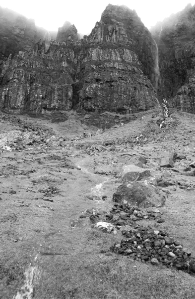
Photo: arjecahn
The ‘Old Man of Storr’ may well be one of the most photographed landforms in Great Britain, but it is just the teaser. It is the ridge itself that best defines this twisted, restless peninsula, and the best way to reach it is by taking the footpath from Flodigarry to Loch Langaig and on to Loch Hasco, then climb till you’re below the crags of the Quiraing. Once there, scramble towards the top till you reach a high point overlooking The Needle, The Prison and The Table - an elevated plateau of short grass legends say was once used to hide cattle from invading Vikings. From above The Table you descend to the southwest then climb to the summit of Bioda Buidhe (466 m) which will provide a wonderful view down over the spectacular winding road through the Quiraing and may also provide views as far as Staffin Bay if the weather is clear. After a further descent you then climb to Bealach (narrow mountain pass) Uige, after which the ridge narrows appreciably before crossing over a series of gentle summits and down to another bealach with a number of sheltered camp sites.
The next summit is Beinn Edra (611 m), with 360-degree views south to the rawness of the Cuillin Massif, formed by intrusions of igneous rock called ‘plutons’; west to the flat-topped hills of MacLeod’s Tables; north to the Isle of Harris and Lewis, Scotland’s largest island and the third-largest island in the British Isles; and east to the mountains of Torridon.
Then you’re climbing again, this time to Sgurr a’Mhadaidh Ruaidh, the ‘Red Fox’ summit with wonderful views down to Loch Cuithir. Hugging the very edge of the escarpment you then ascend to the summit of Baca Ruadh and move along what is now an increasingly undulating ridge before descending to Bealach Hartaval where a short but steep ascent will put you on Hartaval’s 669-m summit.
It’s then down again to Bealach a’Chuirn (a possible camp site with water) from where a long climb over a broad slope will deposit you on the 719-m summit of The Storr, the walk’s high point where you can gaze down upon the Storr Sanctuary’s rock pinnacles which include, of course, the Old Man of Storr. Descending now to Bealach Beag means the best of the ridge is now behind you, and you have a choice: either depart the ridge and make for the car park, or continue along a final angst-inducing ascent before a line of bogs signals your approach to Portree, Skye’s main town set around a lovely natural harbour fringed by a network of hills and cliffs and home to a wide choice of hotels and B&Bs, any of which make an excellent place to stop and pause, to give yourself time to consider the wondrous landscapes you’ve left behind.