The 50 Greatest Walks of the World - Barry Stone (2016)
25. ULURU CIRCUIT
Northern Territory, Australia
Distance: 10.5 km
Grade: Easy
Time: 4 hours
From far away Australia’s best-known natural landmark appears smooth, almost featureless, though up close it is anything but - a weathered giant covered in holes, gashes, caves, valleys and potholes. No matter how you approach it, whether you stand at a distance and watch its ephemeral colours progress through a thousand hues at sunrise or sunset, whether you seek and are given permission by the Anangu people, the rock’s traditional Aboriginal owners, to make the 1.6-km climb to its summit, or whether you walk around its base and discover its mix of acacia woodlands and grassy claypans, it will be an encounter with the symbolic heart of a continent that will live long in the memory.
Uluru is in the Simpson Desert in the southern region of Australia’s Northern Territory, 335 km southwest of the town of Alice Springs. It is 348 m high, and has a circumference of 9.4 km, though as massive as it is, it is like an iceberg, with most of it lying hidden beneath the surface. Geologists call it an inselberg - an isolated rock that rises abruptly from the surrounding landscape. Formed over a period spanning some 600 million years it is the world’s second-largest monolith (the largest being Mount Augustus in Western Australia), its characteristic redness (its actual colour is grey) coming from the rusting of the iron in its arkose rock, a type of sandstone that’s really more of a textually immature sedimentary rock.
ULURU CIRCUIT
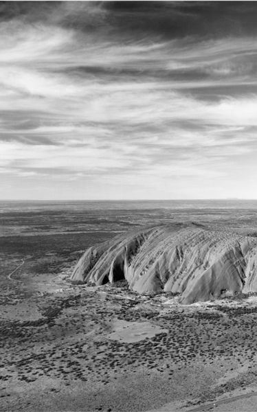
Photo: Corey Leopold
Uluru has been sacred to the Anangu for tens of thousands of years. They believe it to have been born during Tjukurpa, the ‘creation period’, when their ancestral being made not only the Australian landscape, but the entire world. From Tjukurpa came everything they hold dear - traditions, religious heritage, and the ways of daily life. Tjukurpa provides laws on how to care for one another, and how to care for the land, and tells of the inter-relationships that exist between animals, plants, humans and the environment around them in a land that is still inhabited by the ancestors and their spirits. It’s important to know something of this before arriving here. When you come to Uluru you need to understand the ancient world you are entering, both geological and ancestral, a proper appreciation of both that will greatly enhance your sense of discovery.
The Anangu would prefer if you do not walk on the rock, though as mentioned, permits are available and many people in fact do so every year. The circuit (or base walk), however, is there as the ideal compromise and in many ways will provide a far more intimate, solitary experience of Uluru than you’ll get walking in a conga line to the top. The circuit is best started at either the Mala or Kuniya car parks, and is a flat, wheelchair-friendly, easy-to-follow dirt path that in places resembles snake-like grooves, which the Anangu will tell you were made by the ancestral being Kuniya as it journeyed to the nearby Mutitjulu waterhole. Trees and shrubs, including acacias, bloodwoods and native grasses, flourish in Uluru’s sheltered gorges, and some twenty species of native mammals live in its shadows including black-flanked rock wallabies, the marsupial mole, the spinifex hopping mouse and malleefowl, a ground-dwelling solitary bird the size of a chicken.
In addition to walking the full circuit there are also a number of shorter trails as well as ranger-assisted walks. The 1.5-hour, 2-km-long Mala Walk is a free ranger-led walk along the rock’s northern side that begins at 8am each day from October through to April, and 10am from April to September. The ranger, a local Anangu, takes you along a shaded track, pausing to discuss points of Aboriginal law, rock art, and the history and lifestyle of his people, and it ends at the rock’s lovely Kantju Gorge with its large semipermanent waterhole beneath steep canyon walls where you’ll learn about some of the dramatic creation-time events the Anangu believe were responsible for the creation of the rock. The Mutitjulu Walk is a 45-minute return, 1-km walk along Uluru’s southern side that leads to a waterhole which is home to Wanampi, an ancestral watersnake.
Uluru is part of the Uluru-Kata Tjuta National Park, the 512 square miles of which also include the 36,500-million-year old conglomerate rock domes of Kata Tjuta - colloquially known as The Olgas, 25 km to the west of Uluru and set in a surprisingly lush desert landscape. The Olgas - the tallest peak of which is 200 m higher than Uluru - once had a myriad of walks but most have now been closed due to environmental and cultural considerations. The two that remain, however, make any visit here worthwhile: the 3-hour Valley of the Winds Trail, and the shorter Walpa Gorge Walk, both of which end in fine lookouts. The Olgas and Uluru, both of which are close enough to be seen from midway between the two, perfectly bookend any visit to Australia’s ‘Red Centre’.