The 50 Greatest Walks of the World - Barry Stone (2016)
3. PENNINE WAY NATIONAL TRAIL
England / Scotland
Distance: 431 km
Grade: Strenuous
Time: 14-21 days
It’s a cliché to call the Pennine Way the ‘backbone of England’, but it’s true - a 431-km ‘long green trail’ that runs from the town of Edale in the Peak District north via the Yorkshire Dales and the Tyne Valley, Hadrian’s Wall and the Cheviot Hills to the Scottish border at Kirk Yetholm. It was Britain’s first national trail, and remains its most loved. Forty thousand feet of accumulated elevation gain await you if you hike it right through, yet despite its deserved reputation for being the toughest of Britain’s long distance walks its mostly gentle gradients are easier on the joints than ascending on shorter, steeper slogs. Here your biggest concern is and always will be the weather. A series of fine days and you’ll have an adventurous, pleasant three weeks. If the weather turns nasty - and this is the high moors so you bet it will - this Jekyll and Hyde trail can suddenly begin to loom as a genuine obstacle, though not as a test of physical strength. On the Pennine Way the challenges are far more subtle - challenges born of logistics, of mental toughness. And loneliness.
Like most things in life worth having, the Pennine Way wasn’t just dumped in our laps. It had to be fought for. In 1935 Tom Stephenson was a journalist working as the ‘rural correspondent’ for the Daily Herald newspaper when a letter arrived on his desk written by two American women enquiring whether there might be a long distance trail anywhere in the UK similar to America’s Appalachian Trail that they might be able to walk during an upcoming holiday. Stephenson was all too familiar with the answer. In the 1930s much of northern England remained in private hands, and the famous mass trespass at Kinder Scout in Derbyshire in 1932 - when over 400 men and women protested against the lack of access to open country owned by landed gentry - became one of the most successful acts of civil disobedience in British history. ‘Our request, or demand’, said the group’s spokesman Benny Rothman, ‘for access to all peaks and uncultivated moorland is nothing unreasonable’.
Nothing unreasonable indeed. Three weeks later, 10,000 ramblers held a rally in Castleton demanding the same rights that put five of the Kinder Scout protesters into prison, and in the years that followed walkers’ continual lobbying and cajoling of MPs eventually paved the way for the establishment of a network of national parks and long distance trails that would forever open up Britain’s woodlands, moorlands, dales and chalk downs to its people. It also had to be waited for. The Pennine Way wouldn’t open in its entirety until April of 1962, but when it did it was Tom Stephenson, then 72 years of age, who wrote its first guide book. And the route that was chosen would follow - with remarkably few deviations - the path Stephenson himself had mapped.
It begins in the land of the ‘Dark Peaks’ not far from Kinder Scout, the high, wild, bleak north of the Peak District, a land of Millstone Grit-covered limestone with a soil that every winter is saturated with water, a moorland plateau full of sphagnum bogs and the blackest of black peat. Coming off the plateau you descend past reservoirs with fabulous views over Manchester down into the Calder Valley and its woodland river valleys before climbing again, this time over the Haworth moors of West Yorkshire. This is Bronte country. Stop to visit the family vault in Haworth and lament the fact that within eight brief years after the publication in 1847 of Jane Eyre, Agnes Grey and Wuthering Heights, all of their three authors - sisters Charlotte, Anne and Emily - were dead.
PENNINE WAY NATIONAL TRAIL
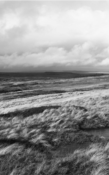
Photo: Kreuzschnabel
You now head into North Yorkshire into the rolling farmlands of the Aire Gap, a pass carved by Ice Age glaciers between the Craven Fault and the Yorkshire Dales’ limestone uplands, a corridor between Yorkshire and Lancashire. Some serious hills now lie ahead of you - Fountains Fell and Pen-y-Ghent, before ancient droving roads take you to Hawes and over Great Shunner Fell to the delights of Swaledale, arguably Yorkshire’s most beautiful dale. A further ascent takes you to the 17th-century Tan Hill Inn, at 1,732 ft England’s highest pub with its gorgeous stone-flagged floors and roaring fireplace. The moors continue to the Stainmore Gap and on to Teesdale, one of England’s most picturesque valleys, before the emptiness of Stainmore Common takes you from east to west across the watershed of the Pennines into the Eden Valley, followed by a long day’s walk over the peaks of the Pennines to Alston and the Maiden Way, a 20-mile-long Roman road that later reverted to a drover’s trail.
After paralleling Hadrian’s Wall for some 11 miles the trail leaves the Pennines behind as it enters Northumberland Forest Park, a section that brings another day of solitude on the moors until you reach Byrness at the foot of the Cheviot Hills. You now have the final stage all before you, and it is not for the faint-of-heart - a bleak, unpopulated, inhospitable, 26.5-mile stretch at a minimum through the Cheviot Hills, including a series of summit-col-summit-col switchbacks of Beefstand Hill, high in the midst of an endless sea of rolling moorlands. If you’re running out of daylight by the time you reach Border Ridge your best option if you’ve a tent is to camp wild at Davidson’s Linn. Better still to depart Byrness before first light to allow enough time to enjoy your approach to Kirk Yetholm and The Border Hotel, the Pennine Way’s official terminus.
You’ll need to think about logistics. Head south to north so the rain and wind will mostly be at your back. Allow three weeks, not two, or you’ll be rushing it, and that’s not why you’re here. Warm, waterproof clothing and decent walking boots are a must, as are a compass and a 1:25,000 scale map. And even though many of the very worst sections of mud and bogs are now paved, prepare for mud and bogs nonetheless so you’ll be able to trudge through whatever this trail can throw at you and not let conditions detract from the beauty and majesty of the wild countryside that surrounds you.