The 50 Greatest Walks of the World - Barry Stone (2016)
17. PAPA STOUR
Shetland Islands, Scotland
Distance: Variable
Grade: Easy
Time: 1 day
If you like following your nose along heavily eroded coastlines - coastlines that have been battered and bludgeoned by waves, storms and winds for millennia and carved into fantastical sea stacks, arches, skerries and enthralling natural features like Kirstan Hol, the world’s fourth-longest sea cave, and where bare bands of pink rhyolite and solidified lava have been laid bare along its coastal rock faces - then you need to come here, to Papa Stour, at the southwestern end of St Magnus Bay to the west of mainland Shetland.
It is the Papey Stora of the Vikings, the ‘large island of priests’ in Old Norse - a nod to the small community of Celtic missionaries who once called it home. A handy stopover for Norsemen who found safe anchorage here, the island had become a Norwegian royal farm by the end of the 13th century and these new incumbents, once established, proved difficult to dislodge. Norwegian estates remained on Papa Stour until well into the 17th century, despite the Shetlands being ceded to Scotland in 1469! Papa Stour also produced the Shetlands’ oldest written extant document, a 1299 petition detailing local grievances. And let’s not forget the abundant evidence of human habitation dating back to Neolithic and Bronze Age communities. History aplenty, if you know where to look for it.
A wall known as the Hill Dyke separates the gravelly sub-soil of the heathlands of the north and west with its covering of thyme, spring squill, woolly hair mosses and heath-spotted orchids from the more fertile land in the east. The island is remarkably flat, with Virda Field at just 87 m its high point, providing a glorious panorama. On the hill behind the island’s primary school you’ll find a series of Neolithic burial chambers, while the remains of several vertical shaft water mills can be found around Dutch Loch. At Da Biggins an archaeological dig has unearthed the foundations of a 13th-century Norse house - a stofa - a timber building constructed with notched logs that was smaller than most Viking longhouses though larger than the homes of the average Shetlander. In 2008 the Papa Stour History Group built a reconstruction of a stofa at the site, using logs imported from Norway. At Housa Voe a circle of 36 stones suggests the presence of a local assembly, and in later centuries lepers were banished here from the mainland and forced to live in isolation in the south of the island, kept alive by the generosity of Papa Stour’s residents. Now that’s a lot of history for one tiny little island.
If you like walking solo and tire of having to nod your head to a flotilla of passers-by then Papa Stour is what you’ve been looking for thanks to a resident population of something around 20, the majority of whom make a living from traditional crofting. The population reached a peak of almost 400 in the 19th century when a fishing port was established at West Voe on the southern tip of Shetland, but soon began to steadily decline.
PAPA STOUR
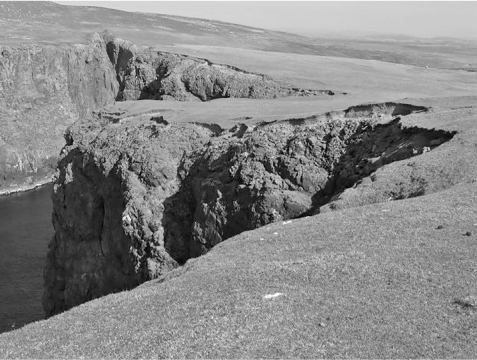
Photo: Doug Lee
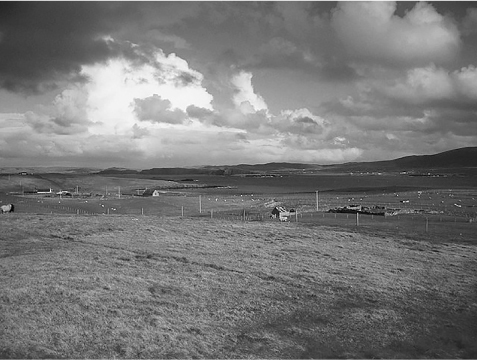
Photo: low cloud
To get here you can catch the inter-island ferry from West Burrafirth, which operates five days a week and takes around 40 minutes in good weather, to Housa Voe (‘House Bay’). There is a car ferry also - the Snolda - but as there’s only one road on the island, and a short one at that, best just leave the car behind - and lace up your walking boots. If you want to stay overnight then you’d better bring a tent as there is no accommodation.
The island has 35 km of rugged, heavily indented coastline but it is its west coast, exposed to the wilds of the Atlantic, that is its most crenellated. There are no marked walking trails on its 828 hectares, but they are hardly needed - the coastline is all you need and you can’t lose your bearings. A short walk from the ferry terminal and you’re passing headlands and blowholes and charming little bays that just keep on beckoning. The erosive power of water is seen in J-shaped indents such as Jerome Coutts’ Head, while other incursions into the landscape, like the Creed, lead to tranquil bodies of calm water. A path of sorts leads you around the island’s southern shore past the Hill of Feilie, where you’ll get a grand view of Sandness Hill across the Sound of Papa, and don’t miss the bizarre leaning offshore rock that is Clingri Geo, a drunken-looking partially collapsed rock with a tunnel through it to the sea. One of the island’s most prominent landmarks, a sea stack called the Horn of Papa, was swept away in a storm in 1953. Plenty of lovely stacks remain, though, including Snolda Stack and Aesha Stack with its gorgeous natural arch.
Geos - linear sea cliff clefts that showcase marine erosion along lines of weakness - are common here where fractured rocks are so susceptible to wave erosion - and always worth walking to just to watch the interplay between the rock and the Atlantic’s angry, churning waters. One of Papa Stour’s most intriguing geos is Christie’s Hole, a labyrinth of tunnels and collapsed caverns so extensive that in 1981 a depression on the surface above one of its caverns collapsed. Rockfalls are common in Papa Stour’s geos, evidence that they are still growing and fracturing.
The island also provides an ideal environment for ground-nesting birds such as Arctic terns and skuas, while more than a dozen species of sea birds including kittiwakes, guillemots, fulmars and razorbills nest in its abundant sea cliffs on some of the most impressive stretches of coastline the Shetlands have to offer, on an island that intrigues on so many levels.