Frommer's EasyGuide to Las Vegas 2017 (Easy Guides) (2016)
9
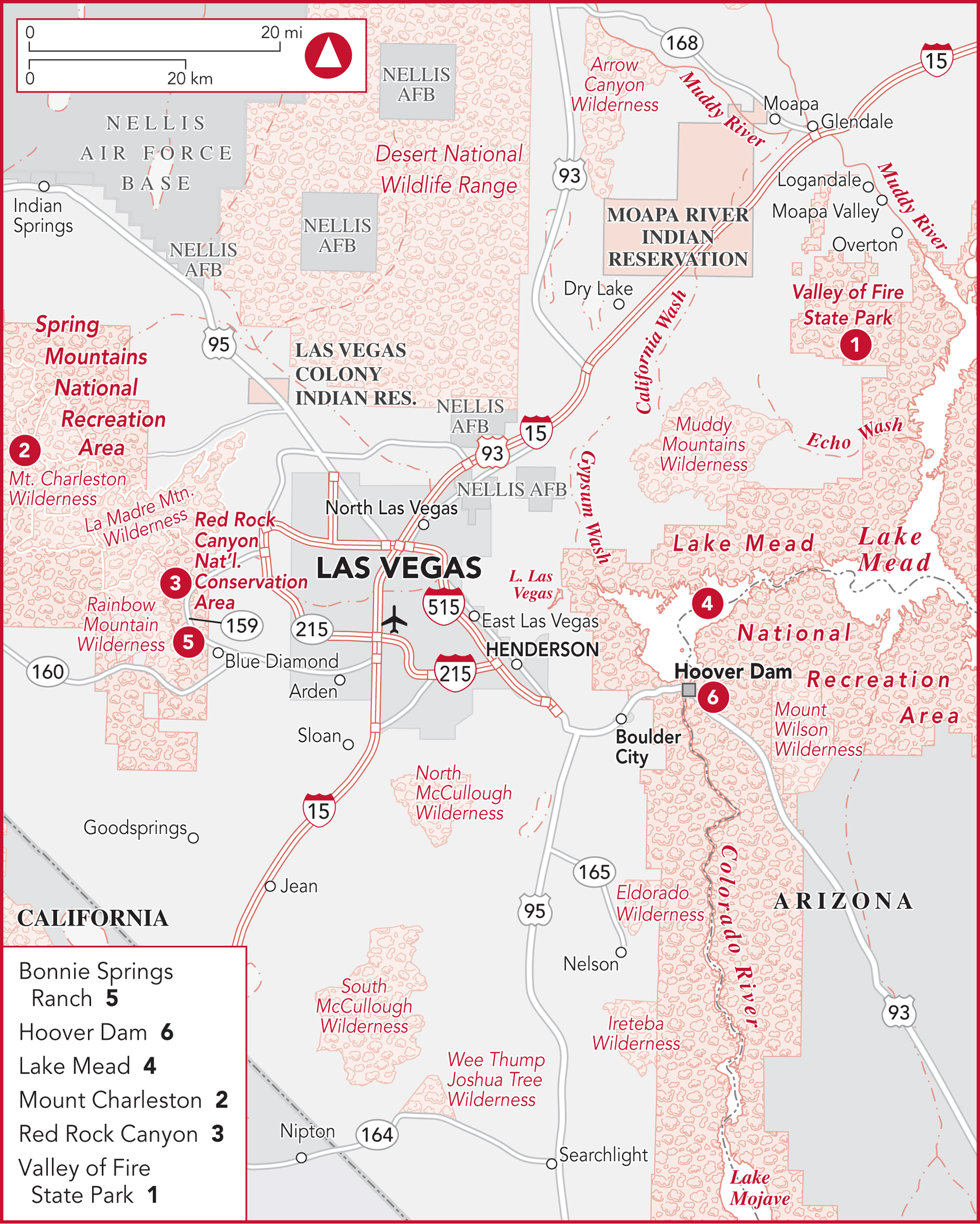
DAY TRIPS FROM LAS VEGAS
Though Vegas is designed to make you forget that there is an outside world, it might do you and your wallet some good to reacquaint yourself with the non-Vegas realm. The good news is that as the most geographically isolated major city in America, there’s nothing but nature in every direction outside its neon-lit borders.
It’s a startling contrast between the artificial wonders of Sin City and the natural wonders that, in some cases, lie just a few miles away. Few places are as developed and modern as Vegas; few places are as untouched as some of the canyons, desert, and mountains that surround it. The electrical and design marvel that is the Strip couldn’t exist without the extraordinary structural feat that is Hoover Dam. Need some fresh air? There are plenty of opportunities for outdoor recreation, all in landscapes that are completely un-Vegas, in the best ways.
HOOVER DAM, LAKE MEAD & LAKE LAS VEGAS
30 miles SE of Las Vegas
This is one of the most popular excursions from Las Vegas, visited by upward of 7 million people annually. Why should you join them? Because Hoover Dam is an engineering and architectural marvel, and it changed the Southwest forever. Without it, you wouldn’t even be going to Vegas. Kids may be bored, unless they like machinery or just plain big things, but expose them to it anyway, for their own good. Buy them ice cream and a Hoover Dam snow globe as a bribe. If you are visiting Lake Mead, it’s a must.
Getting There
Drive east on Flamingo Road or Tropicana Avenue to U.S. 515 S, which automatically turns into I-93 S and takes you right to the dam. This involves a dramatic drive as you go through Boulder City and come over a rise, and Lake Mead suddenly appears spread out before you. It’s a beautiful sight. After the 2010 opening of a bypass bridge (dramatic on its own for its soaring height over the canyon), vehicles no longer pass directly over the bridge to get from Nevada to Arizona, but despite hopes that the bypass would make the commute better, it hasn’t helped much. On a normal day, getting to the dam will take about an hour.
Side Trips from Las Vegas
Go past the turnoff to Lake Mead to Nevada State Route 172, the well-marked Hoover Dam Access Road. As you near the dam, you’ll see a five-story parking structure tucked into the canyon wall on your left. Park here ($10 charge) and take the elevators or stairs to the walkway leading to the visitor center.
If you would rather go on an organized tour, check out Gray Line (www.grayline.com; ![]() 800/634-6579), which offers a half-day tour of the dam from $47 or a daylong tour that includes a visit to the Welcome to Fabulous Las Vegas sign and a tour of the Ethel M Chocolate factory from $57.
800/634-6579), which offers a half-day tour of the dam from $47 or a daylong tour that includes a visit to the Welcome to Fabulous Las Vegas sign and a tour of the Ethel M Chocolate factory from $57.
Hoover Dam ![]()
There would be no Las Vegas as we know it without Hoover Dam. Certainly, the neon and glitz that we know and love would not exist. In fact, the growth of the entire Southwest can be tied directly to the electricity created by the dam.
Construction on the dam began in 1931. An army of more than 5,200 laborers was assembled, and work proceeded 24 hours a day. Though 96 workers were killed during construction, contrary to popular myth, none were accidentally buried as the concrete was poured (it was poured only at a level of 8 inches at a time). Look for a monument outside dedicated to the workers who were killed—“they died to make the desert bloom”—along with a tombstone for their doggy mascot who was also killed, albeit after the dam was completed. Compare their wages of 50¢ an hour to those of their Depression-era peers, who made 5¢ to 30¢.
Completed in 1936, 2 years ahead of schedule and $15 million under budget (it is, no doubt, a Wonder of the Modern Fiscal World), the dam stopped the annual floods and conserved water for irrigation, industry, and domestic uses. Equally important, it became one of the world’s major electrical-generating plants, providing low-cost, pollution-free hydroelectric power to a score of surrounding communities. Hoover Dam’s $165-million cost has been repaid with interest by the sale of inexpensive power to a number of California cities and the states of Arizona and Nevada. The dam is a government project that paid for itself—a feat almost as awe inspiring as its engineering.
The dam itself is a massive curved wall, 660 feet thick at the bottom, tapering to 45 feet where a road crosses it at the top. It towers 726 feet above bedrock (about the height of a 60-story skyscraper) and acts as a plug between the canyon walls to hold back up to trillions of gallons of water in Lake Mead, the reservoir created by its construction. Four concrete intake towers on the lake side drop the water down about 600 feet to drive turbines and create power, after which the water spills out into the river and continues south.
All the architecture is on a grand scale, and the design has beautiful Art Deco elements, unusual in an engineering project. Note, for instance, the monumental 30-foot bronze sculpture, Winged Figures of the Republic, flanking a 142-foot flagpole at the Nevada entrance. According to its creator, Oskar Hansen, the sculpture symbolizes “the immutable calm of intellectual resolution, and the enormous power of trained physical strength, equally enthroned in placid triumph of scientific achievement.”
TOURING THE DAM
The Hoover Dam Visitor Center is a vast three-level circular concrete structure with a rooftop overlook. This facility is where you can buy tour tickets; peruse informational exhibits, photographs, and memorabilia; and view videos about the dam and its construction. The Overlook Level additionally provides an unobstructed view of Lake Mead, the dam, the power plant, the Colorado River, and Black Canyon. Have your camera ready.
It costs $10 to visit just this portion, but for an extra $5 you can get the Powerplant Tour as well (see below). Open every day except for Thanksgiving and Christmas, the center closes at 5pm (4:15pm is the last admission time), though hours vary seasonally.
There are two tours available, the Powerplant Tour and the Hoover Dam Tour. The cost of the former is $15 for adults; $12 for seniors, children 4 to 16, and military personnel and their dependents; and free for children 3 and under and military in uniform. It is self-guided and takes about 2 hours if you really stop to look at and read everything (less if you’re a skimmer). The more extensive Hoover Dam Tour includes the self-guided portion but adds an hour-long guided tour into the deeper recesses of the facility. It is $30 per person; no children age 7 and under are allowed. Tickets for the Hoover Dam Tour must be purchased at the Visitor Center, while admission to the Visitor Center and tickets for the Powerplant Tour are available online. Parking is $10 no matter which tour you take, and the lot takes cash only. There is no need to call ahead to reserve a place, but for more information, call ![]() 866/730-9097 or 702/494-2517.
866/730-9097 or 702/494-2517.
On the Powerplant Tour, visitors go to the center, see a movie, and walk on top of the dam. While both tours include a 530-foot descent via elevator into the dam to view the massive generators, the Powerplant Tour is a self-guided tour aided by the occasional information kiosk or guide/docent stationed at intervals along the way; the pricier Hoover Dam Tour offers the same attractions and viewing opportunities, but it is guided, lasts an hour, and is limited to 20 people. If you plan on taking that tour, be aware that it covers over a mile and a half of walking on concrete and gravel, with no handicapped access. The Hoover Dam Tour is offered every half-hour, with the last tour at 3:30pm, while the final Powerplant Tour admission is at 4:15pm.
For more information on the dam, visit www.usbr.gov/lc/hooverdam.
Lake Mead National Recreation Area ![]()
Under the auspices of the National Park Service, 1.5-million-acre Lake Mead National Recreation Area was created in 1936 around Lake Mead (the reservoir lake that is the result of the construction of Hoover Dam) and later Lake Mohave to the south (formed by the construction of Davis Dam). Before the lakes emerged, this desert region was brutally hot, dry, and rugged—unfit for human habitation. Today, it’s one of the nation’s most popular playgrounds, attracting millions of visitors annually. The two lakes comprise 247 square miles. At an elevation of just over 1,000 feet, Lake Mead itself extends some 110 miles upstream toward the Grand Canyon. Its 700-mile shoreline, backed by spectacular cliff and canyon scenery, forms a perfect setting for a wide variety of watersports and desert hiking.
Having said all that, Lake Mead is in the beginning stages of a crisis so large that if unchecked, it would spell the end for Vegas entirely. The nation’s largest reservoir has experienced a severe drop-off in levels since 2000, a combination of drought, global warming, and increased use. Whole portions of the lake’s edges are now dry, in the process exposing the remains of some of the small towns that were flooded to build the thing in the first place. These have become tourist spots themselves. In 2010, the lake was at 39% of its capacity and hit a record low height of 1,083 feet above sea level. Things got a little better in recent years with increased water flow into the lake, but it is still a fraction of its former self and the long-term risk is still present. According to a research study published in 2008, there is a 50% chance the lake will go dry by 2021, and because it supplies water to Las Vegas (not to mention hydroelectric power), that has grave implications for that city. Let’s encourage those fancy new hotels to put in drought-tolerant plants instead of more grass. And don’t ask for your towels to be changed every day.
Keep in mind that if the lake water shortage continues, many of the following outdoor activities will probably be affected, if they aren’t already.
The Lake Mead Visitor Center, renovated and upgraded in 2013, is 4 miles northeast of Boulder City on U.S. 93, at NV 166 (![]() 702/293-8990). Here, you can get information on all area activities and services, pick up trail maps and brochures, view informative films, and find out about scenic drives, accommodations, ranger-guided hikes, naturalist programs and lectures, bird-watching, canoeing, camping, lakeside RV parks, and picnic facilities. The center has some informative exhibits about the area and is staffed by friendly folks full of local pride. It’s open daily from 9:00am to 4:30pm except Thanksgiving, Christmas, and New Year’s Day.
702/293-8990). Here, you can get information on all area activities and services, pick up trail maps and brochures, view informative films, and find out about scenic drives, accommodations, ranger-guided hikes, naturalist programs and lectures, bird-watching, canoeing, camping, lakeside RV parks, and picnic facilities. The center has some informative exhibits about the area and is staffed by friendly folks full of local pride. It’s open daily from 9:00am to 4:30pm except Thanksgiving, Christmas, and New Year’s Day.
For information on camping, boat rentals, fishing, tours, and more, visit the National Parks Service website at www.nps.gov/lake.
The entry fee for the area is $20 per vehicle, which covers all passengers, $15 if you’re motorcycling, or $10 per person if you’re walking or biking in. Entry fees cover 1 to 7 days and yearly passes are available for $40 per vehicle or individual.
Outdoor Activities
This is a lovely area for scenic drives amid the dramatic desert landscape. One popular route follows the Lakeshore and Northshore scenic drives along the edge of Lake Mead. From these roads, there are panoramic views of the blue lake, set against a backdrop of the browns, blacks, reds, and grays of the desert mountains. Northshore Scenic Drive also leads through areas of brilliant red boulders and rock formations, and you’ll find a picnic area along the way.
BOATING & FISHING The Las Vegas Boat Harbor (www.boatinglakemead.com; ![]() 702/293-1191) rents powerboats, pontoon boats, personal watercraft, and watersports equipment. It also carries groceries, clothing, marine supplies, sporting goods, water-skiing gear, fishing equipment, and bait and tackle. Similar services are offered at the Callville Bay Resort & Marina (www.callvillebay.com;
702/293-1191) rents powerboats, pontoon boats, personal watercraft, and watersports equipment. It also carries groceries, clothing, marine supplies, sporting goods, water-skiing gear, fishing equipment, and bait and tackle. Similar services are offered at the Callville Bay Resort & Marina (www.callvillebay.com; ![]() 800/255-5561 or 702/565-8958), which is usually less crowded. Nonresidents can get a fishing license here ($69 for a year or $18 for 1 day plus $7 for each additional day; discounts for children 15 and under are available; additional fees apply for special fishing classifications, including trout, which require a $10 stamp for taking or possessing that fish). Largemouth bass, striped bass, channel catfish, crappie, and bluegill are found in Lake Mead; rainbow trout, largemouth bass, and striped bass are in Lake Mohave. You can also arrange here to rent a fully equipped houseboat at Echo Bay, 40 miles north.
800/255-5561 or 702/565-8958), which is usually less crowded. Nonresidents can get a fishing license here ($69 for a year or $18 for 1 day plus $7 for each additional day; discounts for children 15 and under are available; additional fees apply for special fishing classifications, including trout, which require a $10 stamp for taking or possessing that fish). Largemouth bass, striped bass, channel catfish, crappie, and bluegill are found in Lake Mead; rainbow trout, largemouth bass, and striped bass are in Lake Mohave. You can also arrange here to rent a fully equipped houseboat at Echo Bay, 40 miles north.
CAMPING Lake Mead’s shoreline is dotted with campsites, all of them equipped with running water, picnic tables, and grills. Available on a first-come, first-served basis, they are administered by the National Park Service (www.nps.gov/lake; ![]() 702/293-8990). There’s a charge of $20 per night at each tent campsite, and up to $35 for RVs.
702/293-8990). There’s a charge of $20 per night at each tent campsite, and up to $35 for RVs.
CANOEING The Lake Mead Visitor Center (see above) can provide a list of outfitters that rent canoes for trips on the Colorado River. A canoeing permit ($22 per person) is required in advance and is available from livery services licensed by the Bureau of Reclamation. Questions about launch permits should be directed to Willow Beach/Black Canyon River Adventures (www.willowbeachharbor.com; ![]() 928/767-4747). You can apply for and receive the permit on the same day that you plan to canoe.
928/767-4747). You can apply for and receive the permit on the same day that you plan to canoe.
HIKING The best season for hiking is November through March (it’s too hot the rest of the year). Three trails, ranging in length from .75 mile to 6 miles, originate at the Lake Mead Visitor Center (see above), which stocks detailed trail maps. The 6-mile trail goes past remains of the railroad built for the dam project. Be sure to take all necessary desert-hiking precautions. (See “Desert Hiking Advice,” below.)
LAKE CRUISES A delightful way to enjoy Lake Mead is on a cruise aboard the Lake Mead Cruises boat Desert Princess ![]() (www.lakemeadcruises.com;
(www.lakemeadcruises.com; ![]() 866/292-9191), a Mississippi-style paddle-wheeler. It’s a relaxing, scenic trip (enjoyed from an open promenade deck or one of two fully enclosed, climate-controlled decks) through Black Canyon and past colorful rock formations known as the Arizona Paint Pots en route to Hoover Dam, which is lit at night. Options include narrated midday cruises ($26 adults, $13 children), Sunday Champagne brunch cruises ($45 adults, $19.50 children), and dinner cruises ($61.50 adults, $25 children). Dinner is served in a pleasant, windowed, air-conditioned dining room. There’s a full onboard bar. Brunch and dinner cruises run April through October, and the midday cruises run February through November. Call for departure times.
866/292-9191), a Mississippi-style paddle-wheeler. It’s a relaxing, scenic trip (enjoyed from an open promenade deck or one of two fully enclosed, climate-controlled decks) through Black Canyon and past colorful rock formations known as the Arizona Paint Pots en route to Hoover Dam, which is lit at night. Options include narrated midday cruises ($26 adults, $13 children), Sunday Champagne brunch cruises ($45 adults, $19.50 children), and dinner cruises ($61.50 adults, $25 children). Dinner is served in a pleasant, windowed, air-conditioned dining room. There’s a full onboard bar. Brunch and dinner cruises run April through October, and the midday cruises run February through November. Call for departure times.
DESERT HIKING ADVICE
Except in summer, when temperatures can reach 120°F (49°C) in the shade, the Las Vegas area is great for hiking. The best hiking season is November through March. Great locales include the incredibly scenic Red Rock Canyon (p. 250) and Valley of Fire State Park (p. 246).
Hiking in the desert is exceptionally rewarding, but it can be dangerous. Here are some safety tips:
1.Don’t hike alone.
2.Carry plenty of water and drink it often. Don’t assume that spring water is safe to drink. A gallon of water per person per day is recommended for hikers.
3.Be alert for signs of heat exhaustion (headache, nausea, dizziness, fatigue, and cool, damp, pale, or red skin).
4.Gauge your fitness accurately. Desert hiking may involve rough or steep terrain. Don’t take on more than you can handle.
5.Check weather forecasts before starting out. Thunderstorms can turn into raging flash floods, which are extremely hazardous to hikers.
6.Dress properly. Wear sturdy walking shoes for rock scrambling, long pants (to protect yourself from rocks and cacti), a hat, and sunglasses.
7.Wear sunscreen and carry a small first-aid kit.
8.Be careful when climbing on sandstone, which can be surprisingly soft and crumbly.
9.Don’t feed or play with animals, such as the wild burros in Red Rock Canyon. (It’s actually illegal to approach them.)
10.Be alert for snakes and insects. Though they’re rarely encountered, you’ll want to look into a crevice before putting your hand into it.
11.Visit park or other information offices before you start out and acquaint yourself with rules and regulations and any possible hazards. It’s also a good idea to tell the staff where you’re going, when you’ll return, how many are in your party, and so on. Some park offices offer hiker-registration programs.
12.Follow the hiker’s creed: Take only photographs and leave only footprints.
VALLEY OF FIRE STATE PARK ![]()
60 miles NE of Las Vegas
The 36,000-acre Valley of Fire State Park typifies the mountainous, red Mojave Desert that surrounds Las Vegas. It derives its name from the brilliant sandstone formations that were created 150 million years ago by a great shifting of sand, and that continue to be shaped by the geologic processes of wind and water erosion. These are rock formations like you’ll never see anywhere else. There is nothing green, just fiery red rocks swirling unrelieved as far as the eye can see. No wonder various sci-fi movies have used this place as a stand-in for another planet. The entire place is very mysterious, loaded with petroglyphs, and totally inhospitable. It’s not hard to believe that for the Indians it was a sacred place where men came as a test of their manhood. It is a natural wonder that must be seen to be appreciated.
Although it’s hard to imagine in the sweltering Nevada heat, for billions of years these rocks were under hundreds of feet of ocean. This ocean floor began to rise some 200 million years ago, and the waters became more and more shallow. Eventually the sea made a complete retreat, leaving a muddy terrain traversed by ever-diminishing streams. A great sandy desert covered much of the southwestern part of the American continent until about 140 million years ago. Over eons, winds, massive fault action, and water erosion sculpted fantastic formations of sand and limestone. Oxidation of iron in the sands and mud—and the effect of groundwater leaching the oxidized iron—turned the rocks the many hues of red, pink, russet, lavender, and white that can be seen today. Logs of ancient forests washed down from faraway highlands and became petrified fossils, which can be seen along two interpretive trails.
LEAVING (LAKE) LAS VEGAS
Originally created as a playground for the rich and famous (Céline Dion had a house here), Lake Las Vegas is a man-made reservoir created in a formerly dry, dusty valley about 20 miles east of the city on the way to Lake Mead. Surrounded by multimillion-dollar houses and rambling upscale condominium complexes, the bulk of the area is privately owned; but curving gracefully around the western lip of the lake is Monte Lago Village, an homage to an Italian seaside community that features accommodations, dining, shopping, entertainment, and recreation options for those with a taste (and a budget) for the finer things in life.
The area was hit hard by the global economic recession, and many of the reasons to visit vanished. The fantastic Ritz-Carlton hotel, the casino, and two of the three golf courses closed. Many of the stores and restaurants went out of business, and most of the development sank into bankruptcy.
Things are improving, with the Ritz reborn as a fancy Hilton, but it’s still a far cry from what its developers hoped it would be.
There are several shops and restaurants at Aston MonteLago Village, Lake Las Vegas Parkway at Strada di Villagio, Henderson (www.montelagovillage.com; ![]() 877/997-6667). Done as an Italianate village with cobblestone streets and candy-colored buildings, it’s a nice place to stroll on spring days.
877/997-6667). Done as an Italianate village with cobblestone streets and candy-colored buildings, it’s a nice place to stroll on spring days.
The former Ritz-Carlton is now operating as the Hilton Lake Las Vegas Resort & Spa, 1610 Lake Las Vegas Pkwy. (www.hilton.com; ![]() 702/567-4700). Though not much has changed in the room and amenities department, a focus on the business traveler has diminished some of the personal touches that made it special. Still the immaculate gardens are serene, the pool is a blissful retreat, and rooms are gorgeous, especially those located on the re-creation of the Ponte Vecchio bridge over the lake.
702/567-4700). Though not much has changed in the room and amenities department, a focus on the business traveler has diminished some of the personal touches that made it special. Still the immaculate gardens are serene, the pool is a blissful retreat, and rooms are gorgeous, especially those located on the re-creation of the Ponte Vecchio bridge over the lake.
On the other side of the lake, the Westin Lake Las Vegas, 101 MonteLago Blvd. (www.westinlakelasvegas.com; ![]() 702/567-6000), is new but in name only, having formerly been a Loews, and before that a Hyatt. Not much has changed with the new ownership except the addition of their trademark “Heavenly” beds and some toning down of the Moroccan-themed decor. There are more than 500 rooms, a spa, several pools, restaurants, recreation programs, kids programs, and more, so you won’t be lacking in things to do here or in ways to be pampered.
702/567-6000), is new but in name only, having formerly been a Loews, and before that a Hyatt. Not much has changed with the new ownership except the addition of their trademark “Heavenly” beds and some toning down of the Moroccan-themed decor. There are more than 500 rooms, a spa, several pools, restaurants, recreation programs, kids programs, and more, so you won’t be lacking in things to do here or in ways to be pampered.
Getting There
From Las Vegas, take I-15 N to exit 75 (Valley of Fire turnoff). However, the more scenic route is I-15 N to Lake Mead Boulevard east to Northshore Road (NV 167) and then proceed north to the Valley of Fire exit. The first route takes about an hour, the second, 11⁄2 hours.
There is a $10-per-vehicle admission charge to the park ($8 for Nevada residents), regardless of how many people you cram inside.
Plan on spending a minimum of an hour in the park, though you can spend a great deal more time. It can get very hot in there (there is nothing to relieve the sun beating down and reflecting off of all that red), and there is no water, so be certain to bring a liter, maybe two, per person in the summer. Without a guide you must stay on paved roads, but don’t worry if they end; you can always turn around and go back to the main road. You can see a great deal from the car, and there are also hiking trails.
Numerous sightseeing tours go to the Valley of Fire; inquire at your hotel.
What to See & Do
There are no food concessions or gas stations in the park; however, you can obtain meals or gas on NV 167 or in nearby Overton (15 miles northwest on NV 169).
At the southern edge of town is the Lost City Museum ![]() , 721 S. Moapa Valley Blvd. (
, 721 S. Moapa Valley Blvd. (![]() 702/397-2193), a sweet little museum, very nicely done, commemorating an ancient ancestral Puebloan village that was discovered in the region in 1924. Artifacts dating back 12,000 years are on display, as are clay jars, dried corn and beans, arrowheads, seashell necklaces, and willow baskets from the ancient Pueblo culture that inhabited this region between A.D. 300 and 1150. Other exhibits document the Mormon farmers who settled the valley in the 1860s. A large collection of local rocks—petrified wood, fern fossils, iron pyrite, green copper, and red iron oxide, along with manganese blown bottles turned purple by the ultraviolet rays of the sun—are also displayed here. The museum is surrounded by reconstructed wattle-and-daub pueblos. Admission is $5 for adults, free for children 17 and under. It’s open daily from 8:30am to 4:30pm, but closed Thanksgiving, December 25, and January 1.
702/397-2193), a sweet little museum, very nicely done, commemorating an ancient ancestral Puebloan village that was discovered in the region in 1924. Artifacts dating back 12,000 years are on display, as are clay jars, dried corn and beans, arrowheads, seashell necklaces, and willow baskets from the ancient Pueblo culture that inhabited this region between A.D. 300 and 1150. Other exhibits document the Mormon farmers who settled the valley in the 1860s. A large collection of local rocks—petrified wood, fern fossils, iron pyrite, green copper, and red iron oxide, along with manganese blown bottles turned purple by the ultraviolet rays of the sun—are also displayed here. The museum is surrounded by reconstructed wattle-and-daub pueblos. Admission is $5 for adults, free for children 17 and under. It’s open daily from 8:30am to 4:30pm, but closed Thanksgiving, December 25, and January 1.
Information headquarters for Valley of Fire is the Visitor Center on NV 169, 6 miles west of Northshore Road (![]() 702/397-2088). It’s open daily 8:30am to 4:30pm and is worth a quick stop for information and a glance at some of the informational exhibits before entering the park. Postcards, books, slides, and films are for sale here, and you can pick up hiking maps and brochures. Rangers can answer your park-related questions. For online information about the park, which is open sunrise to sunset, go to www.parks.nv.gov/parks/valley-of-fire-state-park/.
702/397-2088). It’s open daily 8:30am to 4:30pm and is worth a quick stop for information and a glance at some of the informational exhibits before entering the park. Postcards, books, slides, and films are for sale here, and you can pick up hiking maps and brochures. Rangers can answer your park-related questions. For online information about the park, which is open sunrise to sunset, go to www.parks.nv.gov/parks/valley-of-fire-state-park/.
There are hiking trails, shaded picnic sites, and two campgrounds in the park. Most sites are equipped with tables, grills, water, and restrooms. A $20-per-vehicle, per-night camping fee is charged for use of the campground (plus $10 for utility hookups); if you’re not camping, it costs $10 per vehicle to enter the park.
Some of the notable formations in the park have been named for the shapes they vaguely resemble—a duck, an elephant, seven sisters, domes, beehives, and so on. Mouse’s Tank is a natural basin that collects rainwater, so named for a fugitive Paiute called Mouse, who hid there in the late 1890s. Native American petroglyphs etched into the rock walls and boulders—some dating from 3,000 years ago—can be observed on self-guided trails. Petroglyphs at Atlatl Rock and Petroglyph Canyon are both easily accessible. In summer, when temperatures are usually over 100°F (38°C), you may have to settle for driving through the park in an air-conditioned car.
RED ROCK CANYON ![]()
19 miles W of Las Vegas
If you need a break from the casinos of Vegas, Red Rock Canyon is a balm for your overstimulated soul. Less than 20 miles away—but a world apart—this is a magnificent, unspoiled vista that should cleanse and refresh you (and if you must, a morning visit should leave you enough time for an afternoon’s gambling). You can drive the panoramic 13-mile Scenic Drive (daily 6am-dusk, $7 per vehicle) or explore more in depth on foot, making it perfect for athletes and armchair types alike. There are many interesting sights and trail heads along the drive itself. The National Conservation Area (www.nv.blm.gov/redrockcanyon) offers hiking trails and internationally acclaimed rock-climbing opportunities. Especially notable is 7,068-foot Mount Wilson, the highest sandstone peak among the bluffs; for information on climbing, contact the Red Rock Canyon Visitor Center at ![]() 702/515-5350.
702/515-5350.
There are picnic areas along the drive and in nearby Spring Mountain Ranch State Park (www.parks.nv.gov/smr.htm; ![]() 702/594-7529), 5 miles south, which also offers plays in an outdoor theater during the summer. The entrance fee is $10 per vehicle.
702/594-7529), 5 miles south, which also offers plays in an outdoor theater during the summer. The entrance fee is $10 per vehicle.
Getting There
Just drive west on Charleston Boulevard, which becomes NV 159. As soon as you leave the city, the red rocks will begin to loom around you. The visitor center will be on your right.
You can also go on an organized tour. Gray Line (www.grayline.com; ![]() 800/634-6579), among other companies, runs bus tours to Red Rock Canyon. Inquire at your hotel tour desk.
800/634-6579), among other companies, runs bus tours to Red Rock Canyon. Inquire at your hotel tour desk.
Finally, you can go by bike. Not very far out of town (at Rainbow Boulevard), Charleston Boulevard is flanked by a bike path that continues for about 11 miles to the visitor center/scenic drive. The path is hilly but not difficult, if you’re in reasonable shape. However, exploring Red Rock Canyon by bike should be attempted only by exceptionally fit and experienced bikers.
Just off NV 159, you’ll see the turnoff for the Red Rock Canyon Visitor Center (www.nv.blm.gov/redrockcanyon; ![]() 702/515-5350), which marks the entrance to the park. It features outdoor exhibits on the flora and fauna found in the canyon and you can also pick up info on trails and the driving route. The center is open daily from 8am to 4:30pm.
702/515-5350), which marks the entrance to the park. It features outdoor exhibits on the flora and fauna found in the canyon and you can also pick up info on trails and the driving route. The center is open daily from 8am to 4:30pm.
About Red Rock Canyon
The geological history of these ancient stones goes back some 600 million years. Over eons, the forces of nature have formed Red Rock’s sandstone monoliths into arches, natural bridges, and massive sculptures painted in a stunning palette of gray-white limestone and dolomite, black mineral deposits, and oxidized minerals in earth-toned sienna hues ranging from pink to crimson and burgundy. Orange and green lichens add further contrast, as do spring-fed areas of lush foliage. And formations, such as Calico Hill, are brilliantly white where groundwater has leached out oxidized iron. Cliffs cut by deep canyons tower 2,000 feet above the valley floor.
During most of its history, Red Rock Canyon was below a warm, shallow sea. Massive fault action and volcanic eruptions caused this seabed to begin rising some 225 million years ago. As the waters receded, sea creatures died, and the calcium in their bodies combined with sea minerals to form limestone cliffs studded with ancient fossils. Some 45 million years later, the region was buried beneath thousands of feet of windblown sand. As time progressed, iron oxide and calcium carbonate infiltrated the sand, consolidating it into cross-bedded rock.
About 100 million years ago, massive fault action began dramatically shifting the rock landscape here, forming spectacular limestone and sandstone cliffs and rugged canyons punctuated by waterfalls, shallow streams, and serene oasis pools.
Red Rock’s valley is home to more than 45 species of mammals, about 100 species of birds, 30 reptiles and amphibians, and an abundance of plant life. Ascending the slopes from the valley, you’ll see cactus and creosote bushes, aromatic purple sage, yellow-flowering blackbrush, yucca and Joshua trees, and, at higher elevations, clusters of forest-green pinyon, juniper, and ponderosa pines. In spring, the desert blooms with extraordinary wildflowers.
In the latter part of the 19th century, Red Rock was a mining site, and later a sandstone quarry that provided materials for many buildings in Los Angeles, San Francisco, and early Las Vegas. In 1990, Red Rock Canyon became a National Conservation Area that comprises approximately 197,000 acres.
What to See & Do
Begin with a stop at the Visitor Center; while there is a $7-per-vehicle fee for entering the park, you also can pick up guides, hiking trail maps, and lists of local flora and fauna. You can also view exhibits that tell the history of the canyon and depict its plant and animal life, including the thousands of wild horses and burros, protected by an act of Congress since 1971. Call ahead to find out about ranger-guided tours as well as informative guided hikes offered by such groups as the Sierra Club and the Audubon Society.
The easiest thing to do is to drive the 13-mile scenic loop ![]() (or give it a go on your bike for a moderately difficult ride). It really is a loop, and it only goes one way, so once you start, you are committed to driving the entire thing. You can stop the car to admire a number of fabulous views and sights along the way, have a picnic, or hike. As you drive, observe how dramatically the milky-white limestone alternates with iron-rich red rocks. Farther along, the mountains become solid limestone with canyons running between them, which lead to an evergreen forest—a surprising sight in the desert.
(or give it a go on your bike for a moderately difficult ride). It really is a loop, and it only goes one way, so once you start, you are committed to driving the entire thing. You can stop the car to admire a number of fabulous views and sights along the way, have a picnic, or hike. As you drive, observe how dramatically the milky-white limestone alternates with iron-rich red rocks. Farther along, the mountains become solid limestone with canyons running between them, which lead to an evergreen forest—a surprising sight in the desert.
If you’re up to it, however, we can’t stress enough that the way to really see the canyon is by hiking. Every trail is incredible—glance over your options and decide what you might be looking for. You can begin from the Visitor Center or drive into the loop, park your car, and start from points therein. Hiking trails range from a .7-mile-loop stroll to a waterfall (its flow varying seasonally) at Lost Creek to much longer and more strenuous treks. Actually, all the hikes involve a certain amount of effort, as you have to scramble over rocks on even the shortest hikes. Unfit or undexterous people should beware. Be sure to wear good shoes, as the rocks can be slippery. You must have a map; you won’t get lost forever (there usually are other hikers around to help you out, eventually), but you can still lose your way. Once deep into the rocks, everything looks the same, even with the map, so give yourself extra time for each hike (at least an additional hour), regardless of its billed length.
A popular 2-mile round-trip hike leads to Pine Creek Canyon and the creek-side ruins of a historic home site surrounded by ponderosa pine trees. Our hiking trail of choice is the Calico Basin, which is accessed along the loop. After an hour walk up the rocks (which is not that well marked), you end up at an oasis surrounded by sheer walls of limestone (which makes the oasis itself inaccessible, alas). In the summer, flowers and deciduous trees grow out of the walls.
As you hike, keep your eyes peeled for lizards, the occasional desert tortoise, herds of bighorn sheep, birds, and other critters. But the rocks themselves are the most fun, with small caves to explore and rock formations to climb on. On trails along Calico Hills and the escarpment, look for “Indian marbles,” a local name for small, rounded sandstone rocks that have eroded off larger sandstone formations. Petroglyphs are also tucked away in various locales.
Biking is a tremendous way to travel the loop. There are also terrific off-road mountain-biking trails, with levels from amateur to expert. No need to haul your bike with you on, rent one from one of the recommended shops linked on Friends of Red Rock, (www.friendsofredrockcanyon.org).
The gleaming, luxurious Red Rock Resort (p. 90) gives day-trippers a highly desirable refueling point on a trip to the canyon. Stop by the food court Capriotti’s, the economical submarine sandwich shop. The subs are ideal for takeout for picnics in the park (buy a cheap Styrofoam ice chest at a convenience store) or for in-room dining as you rest up in your hotel post-hike.
Nearby Bonnie Springs Ranch (www.bonniesprings.com; ![]() 702/875-4191) has a cute Wild West old town, horseback riding, a petting zoo, and more. Horseback riding $60 for 1 hour, pony rides $7.50 per child, zoo admission Monday and Tuesday $7, Wednesday through Sunday $10 adults, $7 children.
702/875-4191) has a cute Wild West old town, horseback riding, a petting zoo, and more. Horseback riding $60 for 1 hour, pony rides $7.50 per child, zoo admission Monday and Tuesday $7, Wednesday through Sunday $10 adults, $7 children.
MOUNT CHARLESTON ![]()
About 35 miles NW of Las Vegas
Although officially known as the Springs Mountains National Recreation Area, this region is more popularly referred to by the name of its most prominent landmark, the 11,918-foot-high Mount Charleston. Visible from Las Vegas proper, the mountain and its surrounding recreation areas have been a popular getaway for locals and vacationers alike for decades.
Comprising more than 316,000 acres of the Humboldt-Toiyabe National Forest (the largest in the lower 48), the area is practically an earth science class covering geography of such variety that it almost causes whiplash. As you start up the road toward the peak, you are surrounded by the kind of desert sage brush and Joshua trees that are most predominant at the lower levels. Suddenly the road takes a curve and a dip, and the desert gives way to a pinyon-juniper-based ecosystem, full of craggy canyons and trees. Finally, you dive into the full-on forests of ponderosa and bristlecone pines, which create a lush oasis powered by more than 100 natural springs formed by water and snow runoff that soaks through the porous limestone rock and eventually bubbles to the surface.
Outdoor activities are the predominant lure and include hiking, camping, rock climbing, and, during the winter months, skiing and snowboarding.
Getting There
Head north on I-15 away from the Strip and then transition to U.S. 95 N. About 18 miles of freeway-style driving will bring you to the first of two roads in the Mount Charleston area. Kyle Canyon Road/NV 157 will take you about 17 miles up toward the summit and is where you’ll find the Spring Mountain Visitor Center, open 9am to 4pm daily (![]() 702/872-5486), many of the campgrounds and hiking trails, the Mount Charleston Resort, and the Mount Charleston Lodge. A few miles farther is NV 156, which runs about 18 miles up to the Lee Canyon (see “Snow Sports,” below). It’s only about 35 miles or so from Downtown Las Vegas, but traffic on the freeways in town is often difficult (to say the least) so plan an hour of travel time to be safe. Note: Chains are often required during or after snowfalls, which can be epic in the area. A December 2010 storm dumped a record 90 inches here over the course of several days.
702/872-5486), many of the campgrounds and hiking trails, the Mount Charleston Resort, and the Mount Charleston Lodge. A few miles farther is NV 156, which runs about 18 miles up to the Lee Canyon (see “Snow Sports,” below). It’s only about 35 miles or so from Downtown Las Vegas, but traffic on the freeways in town is often difficult (to say the least) so plan an hour of travel time to be safe. Note: Chains are often required during or after snowfalls, which can be epic in the area. A December 2010 storm dumped a record 90 inches here over the course of several days.
Also note that there are no gas stations, convenience stores, or other services (and that often includes cellphone service) in the area, so be sure to fill up the tank and bring whatever supplies you may need with you.
Outdoor Activities
You might well be satisfied with driving up to the region and, if it’s wintertime, gazing at the snow from the warmth of your vehicle. We know that many of you come to Las Vegas in the winter to get away from the snow, but for those who don’t get to see it very often, snow-covered peaks could very well be an entertaining sight. But if you want to actually get out of the car, there are a number of recreational activities available.
THE GRAND CANYON
The geographically challenged among us believe that the Grand Canyon is just a hop, skip, and a jump from Las Vegas and therefore a great idea for a side trip while visiting Sin City. While this may be true from a strictly comparative basis—the canyon is closer than say, London—it’s not exactly what you’d call “close.”
While the West Rim is closer to Las Vegas at 180 miles and about 2 hours away, the more popular side for visitors is the South Rim at 270 miles and another 2 hours farther, as there’s more to see and do.
The quickest and easiest way to get to the West Rim is via helicopter. Papillon (www.papillon.com; ![]() 888/635-7272), a popular charter service, offers several packages to the west side, including a bird’s eye view of Hoover Dam, Lake Mead, and possibly the Grapevine Mesa. The shorter, 4-hour tour ($129-$219) is just a quick fly-by over the canyon, but the narrated guide, available in multiple languages, is thorough, informative, and excellent. A more expensive package (that extends the tour by an hour for about $100 more) allows for a landing at the bottom of the canyon, 4,000 feet below the rim, where you’re treated to a champagne picnic in one of the most gorgeous settings you’ll ever dine. If you want a full-day excursion, there’s an option to combine the flight to canyon, a boat trip on the Colorado River, and VIP passes on the SkyWalk bridge ($449-$539).
888/635-7272), a popular charter service, offers several packages to the west side, including a bird’s eye view of Hoover Dam, Lake Mead, and possibly the Grapevine Mesa. The shorter, 4-hour tour ($129-$219) is just a quick fly-by over the canyon, but the narrated guide, available in multiple languages, is thorough, informative, and excellent. A more expensive package (that extends the tour by an hour for about $100 more) allows for a landing at the bottom of the canyon, 4,000 feet below the rim, where you’re treated to a champagne picnic in one of the most gorgeous settings you’ll ever dine. If you want a full-day excursion, there’s an option to combine the flight to canyon, a boat trip on the Colorado River, and VIP passes on the SkyWalk bridge ($449-$539).
For the most serene experience, the North Rim is the unsung hero of the Grand Canyon, where visitors can be closer to nature without all the tour bus crowds. But that solitude comes at a price, as the North Rim is the most difficult to get to. Despite it being the same distance as the South rim, this side is more wild and secluded, so a day trip by car isn’t advised. Fortunately between April and November, Papillon heads there for a daylong tour ($319-$369) that packs in as much nature as you can muster. The 8-hour day starts with a prop plane ride with stunning views of Hoover Dam, Lake Mead and the Colorado River before dropping you off at an isolated landing strip at Bar 10 Ranch, a bona fide ranch where they sometimes have to shoo the cattle from the runway. Your guide will take you via ATV on a 2-hour round trip tour down to the North Rim, 3,000 feet above the Colorado River, where you can appreciate the majesty of the canyon and not fight tourists to breathe in the landscape. The tour includes a cowboy’s lunch back at the lodge, and try to stay awake on the flight back home.
Whenever you bring up the West Rim, folks always mention the SkyWalk, and it’s usually not in a favorable manner. More than 1 million pounds of steel went into the construction of this U-shaped footbridge that extends 70 feet from the rim over the canyon. The transparent glass base is supposed to allow visitors to look down and absorb the awesomeness of the Grand Canyon. However, exorbitant fees (about $44, which go to the Hualapai tribe whose reservation the bridge is on) and relatively unreasonable demands—no cameras, no backpacks—keep a lot of visitors away. Before you decide to pay the price of admission, consider that just a few yards from the bridge, Eagle’s Point offers similar, if not better, views absolutely free.
To visit the South Rim, there are more helicopter tours available, but we suggest if you’ve got a whole day to kill, get up early and catch the Papillon Bus Tour ($89-$150). The coach is air-conditioned and comfortable, and makes frequent rest stops. You’ll get off the bus for photo opps at Hoover Dam, drive through the 900-year-old Joshua tree forest, and also receive a voucher for lunch at the National Geographic food court. Like a trip in school, this will be a learning experience, thanks to a knowledgeable driver well-versed in the history and geology of the American Southwest.
Or be the captain of your ship! Renting a car and driving is an excellent and affordable option, especially if you’ve got a group. Four to five hours over the two-lane highway (three to the West Rim) is doable, but not unheard of. Plus you’ll have the luxury of staying as long as you like and exploring on your own terms. We find that many visitors decide to stay overnight, just for the pleasure of seeing the canyon at dusk and dawn. The shifts in light are a remarkable sight here.
If you’re taking your own car, head east on Flamingo Road or Tropicana Boulevard to I-515 S. This becomes NV 93, which crosses over Hoover Dam into Arizona and leads to I-40 at Kingman. Take the interstate east to NV 64 at Williams, Arizona, and follow the signs north. Drivers should be advised that much of the route to the Grand Canyon from Las Vegas is along narrow, twisty roads that can be a challenge and are often jammed with traffic.
CAMPING There are seven campgrounds in the Mount Charleston area, although only the McWilliams, Fletcher View, and Kyle Canyon sites are open year-round. Some have hookups if you are bringing your camper with you, while others are good for just tents and your sleeping bag; most have toilets, fire pits, and other outdoorsy conveniences. Fees range from around $10 to $50, depending on the number of people, type of vehicle, and facilities or hookups. A full listing of the campgrounds is available at the USDA Forest Service website at www.fs.fed.us (then search for the Spring Mountains National Recreation Area). To make reservations for any of the sites, use the National Recreation Reservation Service at ![]() 877/444-6777 or head online to www.recreation.gov.
877/444-6777 or head online to www.recreation.gov.
HIKING Whether you are an expert hiker or a casual walker, there is probably a trail here for you—more than two dozen total. The Echo/Little Falls trail is a relatively easy mile or so through forests that lead to a small waterfall. On the other end of the scale is the South Loop, an 8-mile trek that leads you almost all the way to the summit of Mount Charleston more than 11,000 feet up. You can pick up a trail guide at the Spring Mountain Visitor Center. There is no fee to use the trails, and follow all of the admonitions about bringing plenty of water and not drinking from the natural springs (they may contain parasites that can make you sick).
ROCK CLIMBING There are several rock-climbing opportunities available in the Mount Charleston area, but all of them are do-it-yourself—no cushy controlled environments here. The most popular sites are the Hood along the unfortunately named Trail Canyon Trail, or Robber’s Roost, accessed from the trail head along Highway 158. For more information, pick up a guide at the Spring Mountain Visitor Center.
SNOW SPORTS Lee Canyon (formerly Las Vegas Ski and Snowboard Resort), Highway 156, Mount Charleston (www.leecanyonlv.com; ![]() 702/385-2754), offers three chairlifts and more than 30 trails ranging from beginner to advanced, plus terrain parks for snowboarders and a tubing area. Lift tickets are $40 to $60 for adults, and $30 to $45 for children 12 and under and seniors 60 and over. The facility offers a full array of equipment and clothing rentals; there’s also a small snack bar and sundry shop if you forgot to bring a camera with which to record yourself in full downhill glory (or falling repeatedly, if you are like us). It is usually open late November through early April from 9am until 4pm, but that may vary based on conditions.
702/385-2754), offers three chairlifts and more than 30 trails ranging from beginner to advanced, plus terrain parks for snowboarders and a tubing area. Lift tickets are $40 to $60 for adults, and $30 to $45 for children 12 and under and seniors 60 and over. The facility offers a full array of equipment and clothing rentals; there’s also a small snack bar and sundry shop if you forgot to bring a camera with which to record yourself in full downhill glory (or falling repeatedly, if you are like us). It is usually open late November through early April from 9am until 4pm, but that may vary based on conditions.
Where to Stay & Dine
In addition to the aforementioned snack shop at the Lee Canyon, there is only one other dining option outside of the Mount Charleston Resort (see below). The Mount Charleston Lodge, 5375 Kyle Canyon Rd. (www.mtcharlestonlodge.com; ![]() 702/872-5408), has a rustic dining room with 20-foot ceilings in an A-frame, ski-lodge type building; a big bar; an open fireplace in the center of the room; big windows; and an outdoor patio from which you can enjoy the scenic views from its 7,717-foot elevation. They serve a wide range of American comfort food, and are open from 8am to 8pm Sunday through Thursday and from 8am to 9pm on Friday and Saturday. The lounge is open daily until midnight.
702/872-5408), has a rustic dining room with 20-foot ceilings in an A-frame, ski-lodge type building; a big bar; an open fireplace in the center of the room; big windows; and an outdoor patio from which you can enjoy the scenic views from its 7,717-foot elevation. They serve a wide range of American comfort food, and are open from 8am to 8pm Sunday through Thursday and from 8am to 9pm on Friday and Saturday. The lounge is open daily until midnight.
The Resort on Mount Charleston ![]() This woodsy retreat has undergone some serious improvements over the last few years that have kept the charm of the place, but modernized it and moved it upscale a notch or two. The ski chalet-style buildings (log and stone exteriors) are tucked into a canyon, providing a gorgeous backdrop for a peaceful respite. The lobby has a big fireplace perfect for warming up after a winter hike, along with a small menagerie of stuffed animals that seem de rigueur in a place like this.
This woodsy retreat has undergone some serious improvements over the last few years that have kept the charm of the place, but modernized it and moved it upscale a notch or two. The ski chalet-style buildings (log and stone exteriors) are tucked into a canyon, providing a gorgeous backdrop for a peaceful respite. The lobby has a big fireplace perfect for warming up after a winter hike, along with a small menagerie of stuffed animals that seem de rigueur in a place like this.
The rooms range from standard motel size to presidential suites, all with comfortably modern furnishings, flatscreen TVs, faux fireplaces, iPod radios, DVD players, and more.
On site there is a small spa and fitness center; a full-service restaurant (classic American fare); a sundry store/bistro with quick bites; and a bar complete with billiards and even a few video poker machines if you’re going into gambling withdrawal.
2 Kyle Canyon Rd. www.mtcharlestonresort.com. ![]() 888/559-1888 or 702/872-5500. 61 units. $40 and up double. Resort fee $12 tax included. Free self-parking. Extra person $15. Children 17 and under stay free in parent’s room. Pets under 25 pounds permitted, $25 per animal up to 2. Amenities: 2 restaurants; bar/lounge; spa; free property-wide Wi-Fi.
888/559-1888 or 702/872-5500. 61 units. $40 and up double. Resort fee $12 tax included. Free self-parking. Extra person $15. Children 17 and under stay free in parent’s room. Pets under 25 pounds permitted, $25 per animal up to 2. Amenities: 2 restaurants; bar/lounge; spa; free property-wide Wi-Fi.