Dive Atlas Of The World: An Illustrated Reference To The Best Sites - Jack Jackson (2016)
MALTESE ARCHIPELAGO
by Lawson Wood
THE MALTESE ARCHIPELAGO LIES IN THE central, southern Mediterranean Sea 96km (60 miles) south of Sicily and 467km (290 miles) from the African coast. The Republic of Malta consists of three main islands, Malta, Gozo and Comino, and they are steeped in history. Their language, a curious mixture of Arabic and Latin known as Malti, derives from the various conquests of the islands by the Phoenicians, Carthaginians, Greeks, Romans, Arabs, Normans, Spanish, French and the Knights of St John.
The islands were the most popular overseas diving destination before the Red Sea opened to mass tourism, and remain favourites of German, Dutch and Italian as well as British divers, with some 40,000 visiting each year.
There is little conservation legislation on the islands, other than those rules imposed by the diving industry partners. However, a new conservation policy is gaining strength, spearheaded by local groups and dive centres. One of the first areas to be protected will be Cirkewwa on Malta, and a number of the new wrecks will also be subjected to fishing restrictions. Malta’s climate has to be the best in Europe. In summer the sun blazes in cloudless blue skies, and because these islands are further south than parts of the North African coast, temperatures are high.
MALTA
Malta is the largest of the three islands at 246 sq km (95 sq miles), and is characterized by steep cliffs in the south, deeply indented northern shores and the sheltered areas around the Grand Harbour of Valletta. Cirkewwa, also known as Marfa Point, is next to the ferry terminal for Gozo and is a magnet for dive training and for more experienced divers who want to dive the wreck of the Rozi.
The islands were awarded the George Cross for their diligence in the face of the enemy during World War II. Valletta Harbour has six divable wreck sites, including HMS Maori and the Carolita barge. Other accessible wrecks are the Tent Peg Wreck 12, mv Odile, HMS Jersey 9, the Blenheim bomber 7 the tanker Um El Faroud 6 and cargo ship Imperial Eagle 13. The purposely sunk 52m (171ft) P29 wreck lies 170m (558ft) offshore, between Cirkewwa and Lantern Points, near to the popular Rozi wreck. P29 was an East German minesweeper before being commissioned by the Maltese Navy as a patrol boat in 1996.
1 THE TUGBOAT ROZI
The Rozi was sunk deliberately in 1992 for divers and sits upright on sand at 36m (120ft). It is home to thousands of chromis, bream and sand smelt. Nearby, the Posidonia seagrass beds contain cuttlefish and pipefish.
2 MARFA CENTRAL (THE TRAINING POOL)
With access from the car park down a concrete ramp to the water’s edge and 1m (3ft) of water, this is perfect for trainees, with a rocky seabed of varying depths and a small shelf and mini-wall that eventually drops to 18m (59ft). An excellent night dive, the site is highly regarded for its octopuses, moray eels, shrimps, crabs and golden cup corals.
3 ANCHOR BAY
This lies down the steeply cut road to the small pier opposite Popeye Village. The diving is best out of the bay and around the corner to the left. A massive boulder next to the wall marks the entrance of the cave and has a base of rounded stones. You will find lots of brittle stars and cave shrimps here.
4 MTAHLEB
This is an unspoiled dive site due to the conditions on the shore before you get to the water. Its all right clambering down 300m (984ft) of rugged headland, but it is another matter climbing back up after a deep dive! The vertical walls, ledges, caves and caverns are home to large numbers of wrasse, parrotfish, chromis (Chromis chromis) and grouper.
5 GHAR LAPSI
This is a safe, shallow cave that runs through the headland. It starts in about 3m (10ft) and comes out on a convoluted wall at 6m (20ft), with a large pile of algae-covered boulders at the entrance. It is near the recently sunk Um El Faroud 6, a tanker that sits in 36m (120ft). This huge ship is a ten-minute swim offshore, but can be reached from the shore entry point for the Blue Grotto, or as a boat dive.
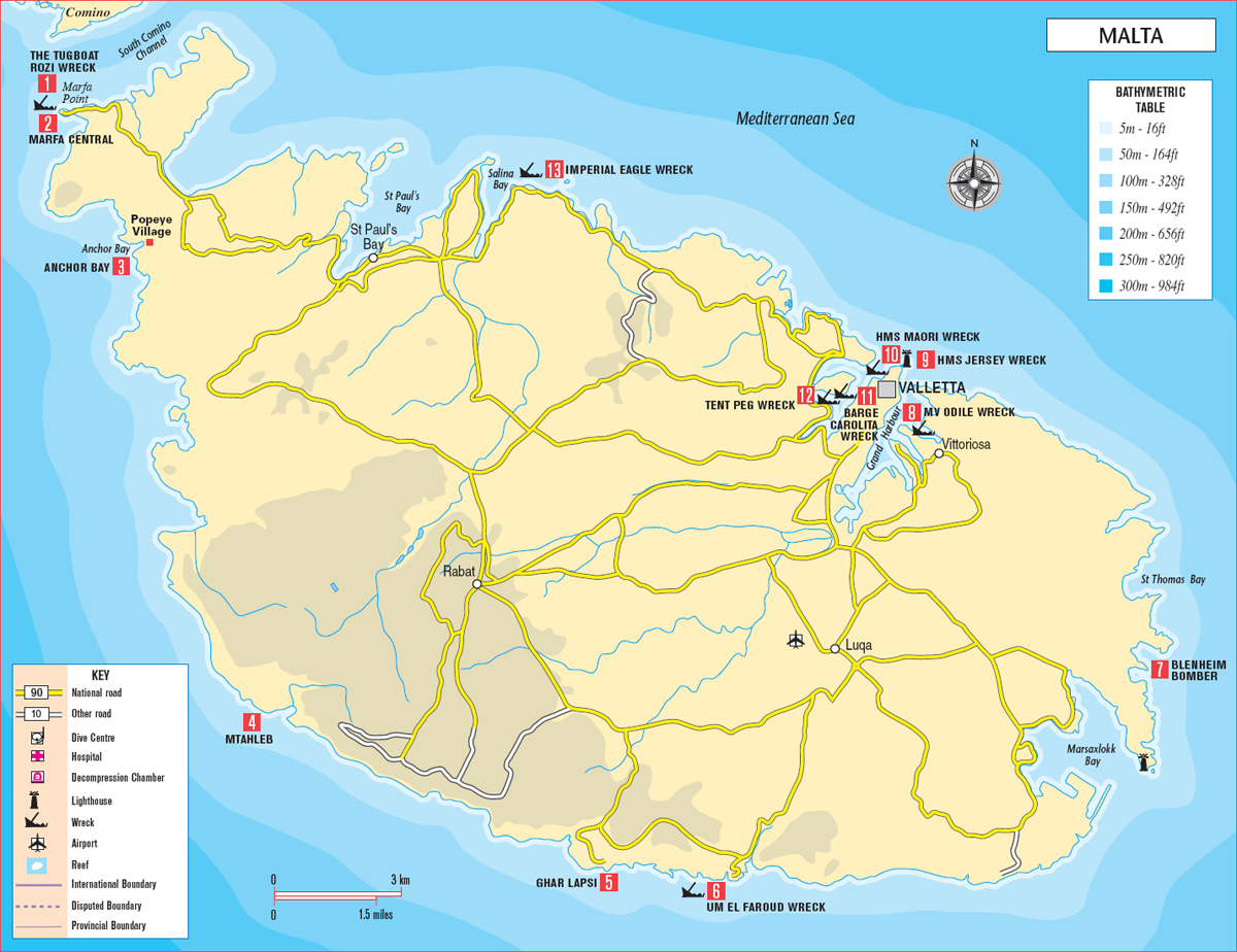
The wreck of the Rozi off Cirkewwa Point sits intact and upright on sand in 36m (120ft). She is always surrounded by large schools of Bogue, chromis, picarel and sand smelt.
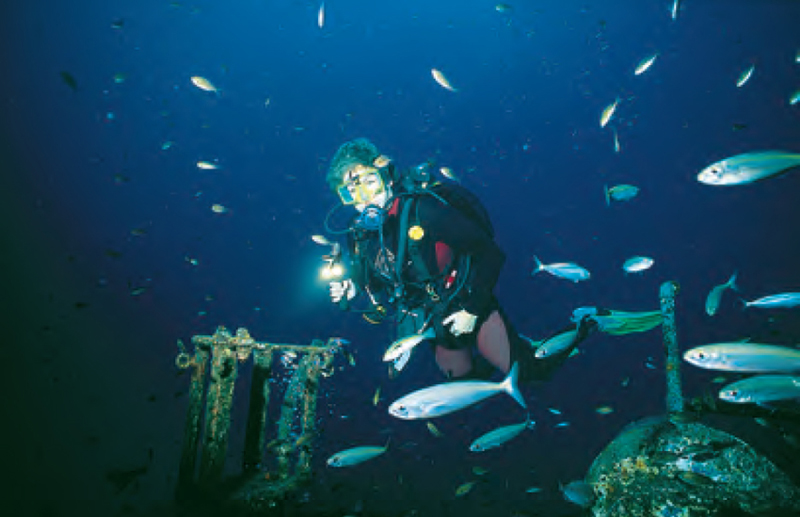
Cardinal fish (Apogon imberbis) are found in groups under overhangs and cave entrances during the day.
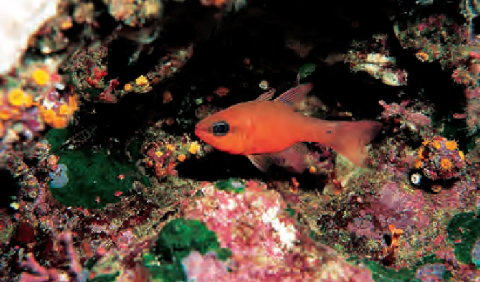
Small caves, tunnels and caverns are common all over the archipelago, covered in algae, corals and sponges.
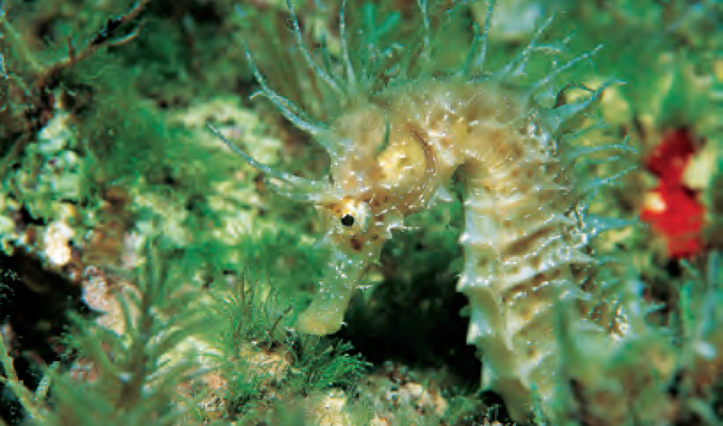
Though common around the islands, the camouflage techniques of the sea horse (Hippocampus ramulosus) makes it hard to find.
8 MV ODILE
First thought to be the wreck of HMS Abingdon, this is in fact an Italian steam freighter, bombed during the war and salvaged in the 1970s. Fairly well broken up, she faces north-west and lies on her port side, covering quite a large area. She is difficult to find without local knowledge because of poor underwater visibility. Penetration is possible for experienced divers with suitable equipment.
10 HMS MAORI
This ship was launched in 1937 and saw considerable action in the Mediterranean, being ultimately responsible for the sinking of the Bismarck. During a massive aerial bombardment in February 1942, she sank quickly from a direct hit. The bows and the entire stern are gone. Part of the bridge is accessible above the muddy seabed of the harbour, but divers should beware the numerous live shells sticking out of the wreckage and mud.
11 BARGE CAROLITA (CORAL)
Struck by torpedo in April 1942, the Carolita sank immediately and now rests against the shore opposite the old naval hospital. Her bow is in 6m (20ft) and her stern at 22m (72ft). Access into this flat barge is fairly restricted, but you can examine the engine room from the damaged stern.
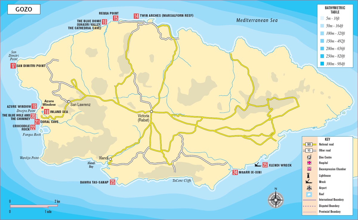
GOZO
Much of the best diving in the Maltese islands is done off Gozo, and day-trip cars and dive-centre vehicles cross regularly on the ferry from Malta. At just over a quarter the size of Malta, it has 43km (27 miles) of coastline and is so popular because much of the diving is done from shore. Like Malta, the northern coast is gently sloping, but here it drops vertically, in many places to more than 60m (200ft). To the south of the island, huge vertical cliffs, make boat diving more appropriate.
To the west, at Dwejra Point, is an area considered to be one of the natural wonders of the Mediterranean. Several fantastic sites can be found within a small area, all accessible from the large car park. Dominated by the spectacular natural arch called the Azure Window, its caves and caverns are among the most scenic dives I have encountered. To the southwest and south the landmass rears up vertically, with only a few entry points except at Xlendi Bay. From St Andrew’s Divers Cove. The former ferries Xlendi, Karwela and Cominoland 25 are all grouped together southeast of Gozo. The Karwela and the Cominoland were both scuttled in Ix Xatt L-Ahmar, Gozo, on 12 August 2006 as artificial reefs for divers. The Karwela is 50m (165ft) long and carried 863 passengers, while the Cominoland is 34m (113ft) and carried 450 passengers and 15 cars.
14 TWIN ARCHES (MARSALFORN REEF)
There is prolific fish life around this underwater rocky spur, which has two large archways cut into the cliff. The first, smaller one starts at 20m (65ft), and directly underneath is a larger one that stretches to the seabed at 45m (150ft). This is best done as a boat dive to avoid a lengthy swim out.
15 REQQA POINT
This headland is very exposed and the entry can be rather difficult over sharp, fossilized rock. A vertical wall drops away to the east (or right) and you can find a shaft that drops through the reef from 6m (20ft) to 16m (52ft). This site is also popular with fishermen.
16 THE BLUE DOME (GHASRI VALLEY, THE CATHEDRAL CAVE)
The Blue Dome at the mouth of Ghasri Valley is best done as a boat dive. The cave is along the right-hand wall, with entry in only 5m (16ft). Inside, the huge roof reflects the outside light, creating the blue-dome effect. Perfect for photography, the cave walls and rocky floor are filled with marine life, including pen shells and sea horses.
17 SAN DIMITRI POINT
This site on Gozo’s most westerly point has a shallow reef that juts out from the headland, where the dive boat can anchor in 6m (20ft). It is done as a deep dive, and includes the thrill of diving with a large school of barracuda. The reef has vertical walls and some interesting potholes carved out by tidal forces.
18 INLAND SEA
The Inland Sea at Dwejra Point is a sheltered lagoon, offering easy access from a small jetty. Pleasure boats use this route to the open sea, so watch out. Passing through a massive fissure in the rock, divers enter a canyon that runs through to open water. First descend to 6m (20ft) and gradually to 25m (80ft) below the cliffs at the seaward side, where the drop continues to more than 60m (200ft). The vertical and underhanging walls are covered with marine life, and the view out to sea is breathtaking.
19 AZURE WINDOW
The site gets its name from the underwater view as you look up towards the natural arch above the surface. It reflects the azure-blue colour as if you were looking through a massive window. The seabed under the arch is covered in large boulders 18m (60ft) below, all covered in an algal fuzz that is home to large numbers of wrasse, bream and Spiny Sea Stars. Entry is from The Blue Hole nearby.
20 THE BLUE HOLE AND THE CHIMNEY
Not a true blue hole (as found in the Bahamas), this one is carved from fossilized rock over generations of winter storms. The outer wall has created a sheltered entry site for divers, who drop down and exit under a huge archway. There is a cave at the bottom left-hand corner near the archway which is home to some interesting tubeworms and anthias. The wall leading to the western headland is vertical and sea horses are found here. Further towards the corner, a thin fissure leads up to a colourful, narrow chimney.
21 CORAL CAVE
Entry is by taking a giant stride off the fossilized rocky shoreline, directly over this semicircular cavern, which has a sandy bottom 30m (100ft) below. Breathtaking in scale, the walls are covered in delicate hydroids and bryozoans that resemble true corals. Framed by fish, the vertical wall to the right (or north) eventually leads you around to the top side of the Chimney, then on to the Blue Hole, where the best exit is.
22 CROCODILE ROCK
A shallow platform of ancient seabed separates Crocodile Rock from Dwejra Point, and this is where a dive boat can anchor safely in 7m (23ft). Reminiscent of Shark Reef in the Red Sea, it is a natural amphitheatre with near-vertical sides. It drops away below you and the dive is conducted around the outer wall, where large shoals of Salema or Saupe are always encountered. This site is also known for its grouper, but then you must dive fairly deep to see them.
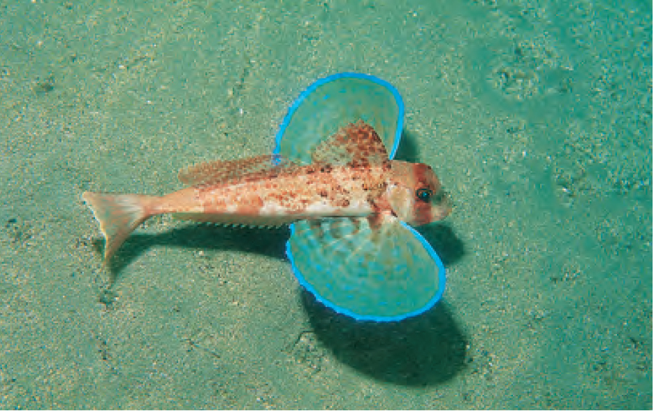
Streaked Gurnard (Trigloporus lastoviza) occur on most sandy areas, often coming close to shore in search of food.
23 DAWRA TAS-SANAP
Just around the corner from Xlendi Bay, and only done as a boat dive, this site features a huge natural arch with encrusted boulders at its base. On the southern wall there is a large cavern in 18m (60ft). Follow the vertical wall on your left to a sheltered bay where nudibranchs and spiny lobsters are to be found.
24 MGARR IX-XINI
This is another safe and easy shore dive, with access directly from the shore in front of the car park. The sandy seabed is popular with photographers seeking Flying Gurnards, flounders and cuttlefish. The wall on the right leads to the entry point at Ta’ Cenc, and there are a number of caves on the way.
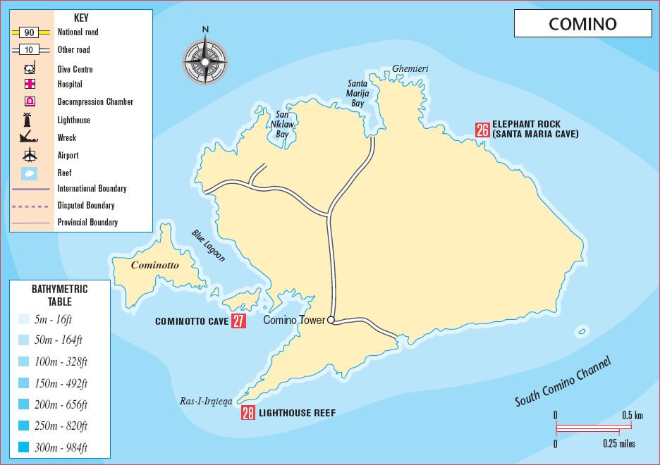
COMINO
Once a pirate’s haven, Comino is dominated by a square tower built in 1618 to protect the Comino channel from raiders. The smallest inhabited island in the archipelago at 3 sq km (1 sq mile), it lies midway between Malta and Gozo. The Blue Lagoon here gets hundreds of snorkelling and diving visitors whenever sea conditions allow the crossing.
26 ELEPHANT ROCK (SANTA MARIA CAVE)
This is a large cave and cavern system that runs more than 30m (100ft) through the headland to connect with another cave. At this junction a shaft opens to the sky, increasing the pleasure of the dive. The site is popular with fish-feeders and the fish are friendly.
27 COMINOTTO CAVE
Often blown out due to the surge, which has created an interesting cavern with a chimney at the far end, this cave has walls pockmarked by small sea urchins, snails and corals. There is a lot of sea grass at the entrance, and cuttlefish are common.
28 LIGHTHOUSE REEF
To the southwest of the island, a small navigational light marks one of its best dive sites. A chimney drops through the reef from 6m (20ft) to 18m (60ft) and big boulders have created numerous swim-throughs. The dive boat anchors on the old limestone shelf next to the chimney entrance. The sides are rather rough, because of the ancient skeletons of tubeworms and corals, so care should be taken. On exiting the cave at the bottom of the reef, groupers and numerous wrasse can be seen among the boulders. Large sea stars are everywhere and sea horses have also been found here.
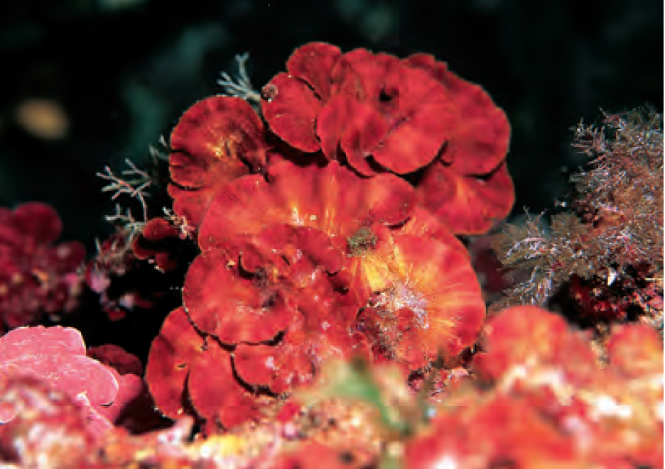
Known as the Sea Rose, the colourful algae Peyssonnelia squamaria prefers low light and is found at cave entrances.
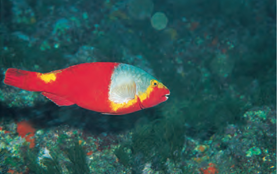
It is only in the female stage that the Mediterranean Parrotfish (Sparisoma cretense) displays such colourful markings.
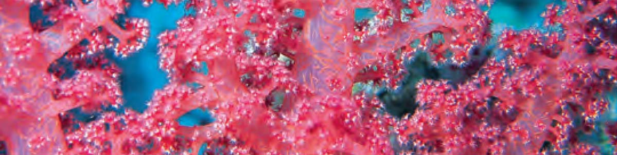
Dendronephthya Soft Tree Corals swell up to their full glory in strong currents, extending fully to maximize their chances of capturing plankton in the passing current.