Dive Atlas Of The World: An Illustrated Reference To The Best Sites - Jack Jackson (2016)
THE PACIFIC OCEAN
by Jack Jackson
BY FAR THE LARGEST OF THE WORLD’S OCEANS, the Pacific stretches from the Arctic to the Antarctic and lies between Asia and Australia in the west and the Americas in the east, roughly one-third of the earth’s surface and double the area of the Atlantic Ocean.
The Pacific meets the Arctic at the Bering Strait and the Atlantic in the Drake Passage between South America’s Tierra del Fuego and Antarctica’s Graham Land. The border with the Indian Ocean is considered to run northwest across the Timor Sea from Australia’s Cape Londonderry, along the southern shores of the Lesser Sunda Islands and the island of Java, and then across the Sunda Strait to the shores of Sumatra. Between Sumatra and the Malay Peninsula the boundary is usually drawn across the Singapore Strait. To the south of Australia the boundary extends across the Bass Strait and from Tasmania to the Antarctic Ocean, which commences at latitude 55° South.
The Pacific covers 165,250,000 sq km (63,800,000 sq miles) - more than the total land surface of the earth. Covering such a vast area with a wide variation in temperatures and conditions, the Pacific is extremely varied in its coastal and island habitat and has great species diversity. Although there is diving in the colder waters of China and Japan, by far the most diving in the world is done on the coral reefs and islands in the tropical Pacific from Taiwan to Hawaii in the north to Australia’s Great Barrier Reef and Oceania in the south. Further south, along the Australian coast, conditions change to temperate waters and species that continue to New Zealand.
In the north, cold water, strong tidal currents and upwellings in summer bring nutrient-laden waters to fish and crustaceans, many of which are larger than their tropical counterparts. The Californian coast is a temperate-water diving region, while offshore of southern California there is cage diving for Blue and Mako Sharks. Grey Whales breed on the ocean side of the Baja Peninsula in winter. On the Farallon Islands researchers study Great White Sharks. The Gulf of California (Sea of Cortés) was once a paradise for migrating marine mammals. However, it has been damaged by overfishing, despite marine reserves. Before divers discovered Cocos and Malpelo islands, the seamounts of the Sea of Cortés were the places for shoaling hammerheads, but few are left now.
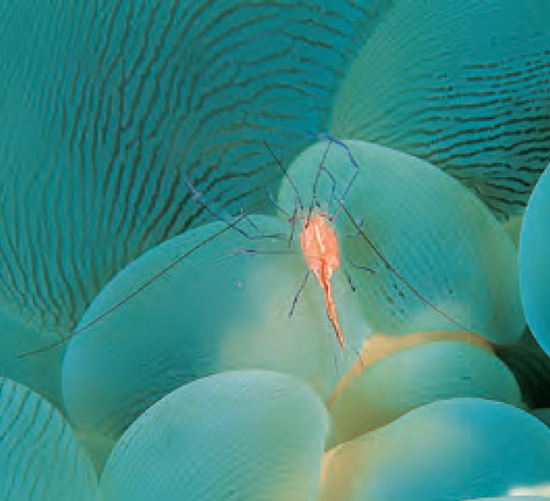
A commensal shrimp living on a host Bubble (Grape) Coral (Plerogyra), which can sting soft human skin.
In addition to the Pacific coasts of Mexico, Costa Rica and Panama, the most popular diving in this region is at Cocos, Malpelo and the Galápagos Islands. Panama’s Golfo de Chiriqui claims the most extensive coralline reefs of the Central American Pacific and Ecuador’s Isla de la Plata for the South American Pacific. There is diving in Peru and Chile, even on volcanic Easter Island (Isla de Pascua), one of the most isolated islands in the world.
The western Pacific includes the Bering Sea, Sea of Okhotsk, Sea of Japan, Yellow Sea, East China Sea and South China Sea. The major rivers of eastern Asia, whose basins contain over a quarter of the world’s population, drain into the Pacific by way of these marginal seas.
Most islands lie between the tropics of Cancer and Capricorn and in the western Pacific. Taiwan, the Philippines, Borneo, Indonesia, New Guinea and New Zealand are continental. The volcanic Hawaiian archipelago consists of around 2000 islands, but the term Hawaiian Islands usually refers to those at its eastern end. Micronesia, lies mainly north of the equator and west of the 180° meridian east of Greenwich. Melanesia is south of Micronesia, and Polynesia is to the east.
Further east, Cocos and Malpelo Islands are close to the equator and the Galápagos Islands are on it, but cold currents affect the marine life. All are volcanic, with a small amount of coral that suffered in the 1997/8 El Niño.
The pressure systems of the Pacific closely follow the planetary system, where the patterns of air pressure and wind result from the earth’s rotation (Coriolis Force) and the inclination of its axis towards the sun. In general the atmospheric circulation in one hemisphere mirrors that in the other. The huge amount of open water influences pressure and wind patterns over it. The climate in the southern and eastern Pacific, where the trade winds and westerlies are steady, is the most regular on the planet. However, in the northern Pacific it is more variable - the cold winters of the east coast of Russia contrast sharply with milder winters in British Columbia.
The Pacific’s trade winds are most prominent over the northeast and southeast Pacific between the latitudes of 30°N and 40°S. The angle of the earth’s rotation on its axis and its revolution around the sun limits the seasonal shifting of the Pacific trade wind belts to about 5° of latitude. The easterly winds along the equator form the intertropical airflow and tend to be strongest in the eastern Pacific. In the equatorial region, the trade winds of the northern and southern hemispheres converge, giving rise to the doldrums.
Although the climatic conditions of the trade wind belts are generally uniform, storms known as typhoons in the western Pacific do originate there. The ideal conditions for their development occur between the parallels of 5° and 25° north in late summer when the temperature of surface water is at least 27°C (80°F).
Within the belts of westerly winds, cold easterly winds from the polar regions meet the warm westerly winds of the middle latitudes producing travelling depressions. Their region of convergence, the polar front, is most evident in winter when the contrast in temperature and humidity is greatest. Westerlies in the southern hemisphere are strong and the gales accompanying their depressions gave rise to the name Roaring Forties after the latitude where they commonly occur.
In the western Pacific, monsoons, which are caused by land-sea temperature differences, replace the planetary system.
All three types of tide occur. At some places in the South Pacific the oscillation period follows the sun. Instead of getting later each day by about 50 minutes, tides in places such as Tahiti are about the same for several days in succession. Mixed tides occur along the Pacific coast of North America. Diurnal tides occur in the Gulfs of Tonkin and Thailand, the Java Sea, and Bismarck and Solomon seas. In general, tidal ranges in the Pacific are small, but the upper reaches of the Gulf of California and Korea Bay have ranges of more than 10m (33ft).
The average depth is 4280m (14,040ft) and the Mariana Trench is 11,034m (36,201ft) - the deepest of any ocean.
ABU SAYYAF
The southwesternmost islands of the Philippines are hide-outs for a dissident Muslim faction loosely termed Abu Sayyaf. Now advised and assisted by Osama Bin Laden’s Al-Qa’eda (Qa’ida) terrorist organization, Abu Sayyaf has recently become more active and taken tourists hostage in Malaysia and southern Palawan. Until the Philippines armed forces have gained control of this group, divers should avoid Basilan Island and the Filipino islands to its southwest and take government advice over the far west of Mindanao.
The security at all resorts and airstrips has been increased and Club Noah Isabelle has even set up its own radar defence system and regularly patrols the fish sanctuary.
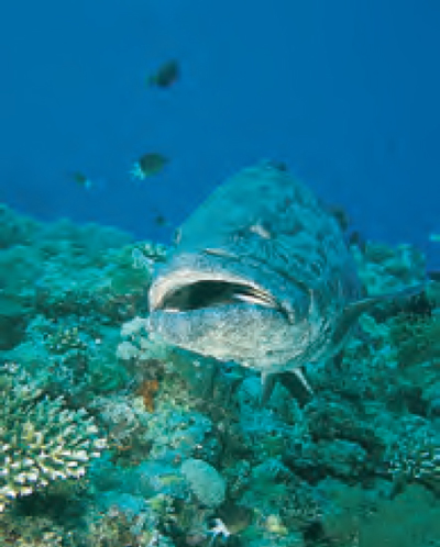
A Potato Grouper (Epinephelus tukula). Known in Australia as a Potato Cod, it is the joint second-largest grouper.
Seismically active over much of its area, the zone that surrounds the Pacific from New Zealand to southern Chile is known as the Ring of Fire. The geological history of the western Pacific basin is not fully understood. Some fragments of oceanic crust have escaped remelting and now lie against the coasts of Japan, California and South America, but much of the original structure has been destroyed by subsequent volcanic activity.
The eastern Pacific basin is simpler. West of the American continent, at the East Pacific Rise, the crust being pulled towards the western Pacific is separating at 16.5cm (6.5in) a year, the fastest in the world. A branch of this rise is opening the Gulf of California and two less active ridges branch eastward from it. They are the Galápagos Spreading Center near the equator and the Chile Rise in the southeast. Also in the eastern Pacific are the east-west fracture zones and submerged volcanoes, some of which have merged, like the Cocos Ridge. The Pacific has many flat-topped seamounts (guyots) rarely found in other oceans.
The most important influence on the vertical circulation of the Pacific is the dense, cold water from the Antarctic, which sinks and then spreads northward to form the bottom layer of the greater part of the ocean. Deep-water circulation is also influenced by the sinking surface water at zones of convergence, which sink to about 90m (300ft) before spreading laterally. To compensate, other water rises (upwelling) at zones of divergence, particularly along the coasts of the Americas.
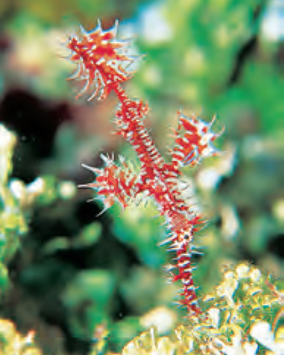
Masters of camouflage, Harlequin Ghost Pipefish (Solenostomus paradoxus) hide among gorgonias, weeds or crinoids.
Pacific trade winds drive surface waters west to form the North and South Equatorial currents. Between them is the Equatorial Countercurrent from the Philippines to Ecuador. Most of the North Equatorial Current turns north near the Philippines to form the warm Kuroshio (Japan) Current. East of Japan the Kuroshio swings east to form the Kuroshio Extension, which further east becomes the North Pacific Current. The cold, southeast-flowing California Current forms the eastern section of the returning branch of the North Equatorial Current.
Most of the South Equatorial Current divides into three branches while flowing west. The two westernmost branches turn south off Australia’s east coast to form the East Australian Current, which becomes the Tasman Current, turns back to the northeast and disperses west of New Zealand. The easternmost branch flows to the south, roughly along the 180° meridian, turning east as the warm South Pacific Current at 50° south. Between 80° and 90° west it turns north and then west as the Mentor Current before returning to the South Equatorial Current.
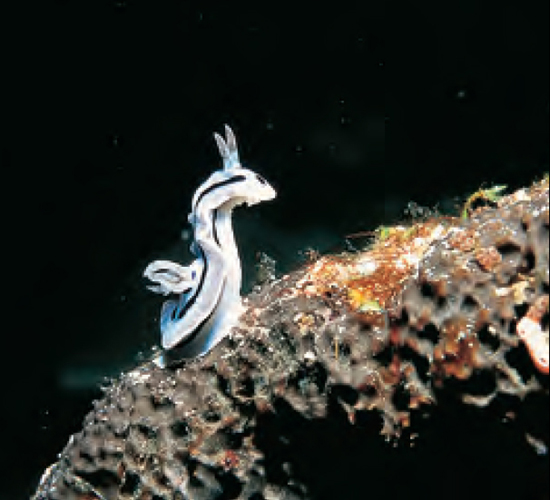
A Chromodoris willani nudibranch off Sumilon Island, Philippines. This species feeds on sponges on exposed reefs and slopes.
One branch of the cold Antarctic Circumpolar Current becomes the Humboldt (Peru) Current, whose nutrient-rich upwellings produce prolific fishing grounds.
The north Pacific’s currents and freshwater run-off are ideal for bottom-living species. The cold-water coasts of America have vast kelp beds harbouring a marine diversity almost as good as on coral reefs. Whales make long migra tions from cold-water feeding to warm-water breeding and calving grounds.
Nutrient-rich upwellings support some of the world’s largest fisheries off Japan and Peru and the western Pacific has the richest and most extensive coral reefs of any ocean and a great variety of pelagic species.
The Pacific suffers from the same problems of pollution, sedimentation and destructive fishing as any of the big three oceans, but overfishing is the largest threat of all.
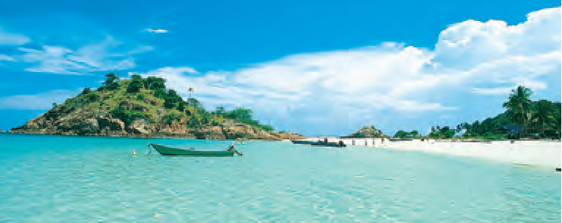
Empty beaches, clear turquoise seas and wonderful scenery exemplify Pulau Redang. The surrounding seas have the finest coral in Peninsular Malaysia and have been extensively studied by the WWF.
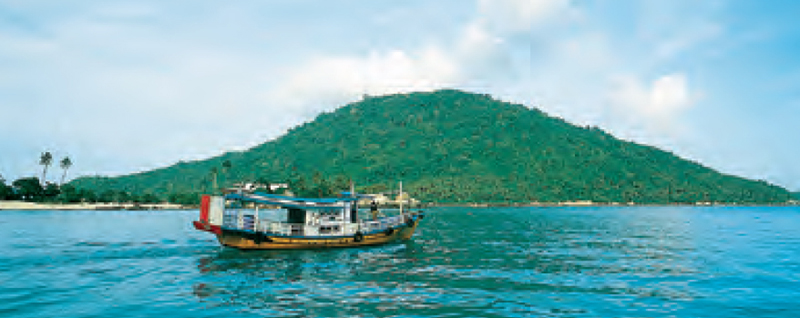
A fishing boat converted into a ferry leaves Pulau Perhentian Besar, the largest of the Perhentian Islands. Empty beaches and interesting jungle walks also make it the most popular.