Dive Atlas Of The World: An Illustrated Reference To The Best Sites - Jack Jackson (2016)
THE ATLANTIC OCEAN
by Jack Jackson
THE ATLANTIC IS THE SECOND LARGEST of the world’s oceans. The boundaries defining its northern limits are not universally accepted, but the two most common latitudinal boundaries are 65° North and the Arctic Circle - 66° 32’ North. The western boundary is the Americas and the eastern boundary is Europe and Africa. To the south the most widely accepted limit between the Atlantic and the Pacific oceans is the Drake Passage. Between the Atlantic and Indian oceans it is the 20° meridian East through Cape Agulhas at the southern end of Africa.
With an area of about 82,000,000 sq km (31,660,000 sq miles) without its attendant seas and 106,460,000 sq km (41,100,000 sq miles) with them, the Atlantic covers one-fifth of the earth’s surface and has the largest river drainage of the world’s oceans.
CONDITIONS AND COASTAL HABITATS
In the north there are temperate waters and some unusual conditions caused by the warm Gulf Stream. There is temperate water diving off eastern North America, while Bermuda, Florida, the Bahamas and the countries at the northern end of South America are Caribbean-like. Brazil’s coastline has conditions from Caribbean-like to temperate. Argentina has a long temperate coastline and large mammals including some unique Orcas that hunt at the edge of the beach.
Europe has lots of temperate water diving. Islands off the west coast of Africa have Mediterranean conditions when the weather is fine. Central west Africa has the wettest climate in Africa and large river outlets give murky waters. Near the coast divers have died of dysentery carried in river run-off, but diving is safer at islands well offshore such as Principe. Namibia’s coast is cold and murky, so most diving is done in inland sinkholes. There is diving off the Atlantic coast of South Africa. The remote islands of Ascension, Saint Helena, Tristan da Cunha, and the Falklands have good temperate water diving.
Most islands are in the Caribbean. The British Isles, Falkland Islands and Newfoundland are continental. Iceland, the Azores, Ascension, Saint Helena, Tristan da Cunha, the South Sandwich Islands, the West Indies and Bermuda are exposed tops of submarine ridges. The Canaries, Cape Verde and Madeira rise from the continental margins of Africa while the Bahamas are coral islands lying on the Blake Plateau.
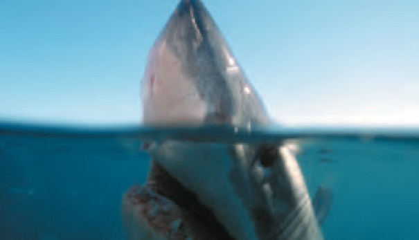
Off South Africa, Great White Sharks are observed from the safety of a steel cage. They are drawn closer with chunks of fish or meat.
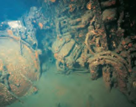
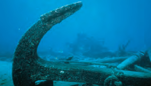
Shipwrecks are a major draw off the East Coast of North America. This is the torpedo room of the German submarine U-352.
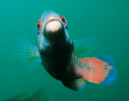
Cuckoo Wrasse (Labrus bimaculatus) are among the more colourful fish of the Eastern Atlantic. They live up to 17 years.
The large air masses and the resulting winds from North America determine most of the weather over the North Atlantic. In winter westerly winds at altitude push cold air from Canada and Alaska to the Atlantic seaboard. Where cold polar air meets mild air from the Gulf of Mexico or the Gulf Stream, low-pressure areas form and develop into strong vortices as they move towards Newfoundland and Iceland. These cyclonic storms carry tropical heat and moisture north and help to maintain the prevailing westerlies of the mid-latitudes, which are half as strong and about 10° further north in summer than in winter.
Iceland is normally dominated by low pressure, but in some winters high pressure systems prevail and storms leaving the North American coast are blocked and diverted to the Azores. Warm maritime air that normally gives Europe relatively mild winters is replaced by cold air from the European Arctic and Siberia.
HURRICANES
Between 15° and 30° North, high pressure prevails so the weather is usually fine. South of this, the northeast trade winds blow steadily. However, during late summer and early autumn, large amounts of heat are released when vapour rises from the warm ocean and then condenses as heavy showers. This can develop into tropical-storm vortices called hurricanes, which often move clockwise around the North Atlantic high-pressure belt and into the prevailing westerlies, ending up around Iceland. Occasionally they reach the British Isles and even the Azores.
Fog banks off the Grand Bank in summer are due to moisture in warm air from the continent and the Gulf Stream condensing as it flows over the cold Labrador Current.
WINDS AND TIDES
In the South Atlantic a belt of westerlies extends from roughly 40° South almost to Antarctica. The South Atlantic high-pressure region is centred around 30°S. Wind rotation around the high-pressure region is opposite to that in the northern hemisphere because of the effect of the earth’s rotation (Coriolis Effect). This circulation gives the southeast trade winds on the northern side of the high-pressure region, which meet the northeast trade winds in the intertropical convergence zone (the doldrums), around the equator.
The weather is usually fine in the latitudes of high pressure. The great storms of the southern hemisphere westerlies are due to the temperature contrast between the Antarctic continent and the adjacent open ocean.
Tides in the Atlantic are mostly semidiurnal. Labrador, some areas of the Mediterranean, Gulf of Mexico, Caribbean, the southeastern coast of Brazil and Tierra del Fuego have mixed tides. Purely diurnal tides occur in parts of the Gulf of Mexico. Tidal ranges vary from less than 1m (40in) in the Gulf of Mexico, Caribbean, and Mediterranean to 16m (52ft) in Canada’s Bay of Fundy.
OCEAN TOPOGRAPHY
The shape of the Atlantic coastline of the Americas fits closely that of Europe and Africa. Between the two, the S-shaped Mid-Atlantic Ridge also fits. Crustal material on either side of the ridge is younger than that on the seafloor to either side. This indicates an uprising of material from the earth’s mantle onto the crest of the ridge as the seafloor spreads.
The Mid-Atlantic Ridge is a mountain range and fault zone extending the length of the Atlantic. The Atlantic basin is widening, causing the flanks of the ridge to build up from accumulating lava. In places the ridge reaches the surface as volcanic islands. Ancient volcanoes, singly or in rows, rise as seamounts, islands and, occasionally, guyots. Moving away from the Mid-Atlantic Ridge towards the continents, there are abyssal plains followed by undulating continental rises. The Romanche furrow, near the equator, is a deep break in the ridge, which allows deep water to flow freely between east and west.
The average depth of the Atlantic is 3300m (10,925ft) and maximum depth 8380m (27,493ft) in the Puerto Rico Trench in the North Atlantic.
The North and South Atlantic central waters make up the surface waters of the Atlantic. The sub-Antarctic intermediate water drops to depths of 1000m (3300ft), the North Atlantic deep water reaches depths of around 4000m (13,200ft) and the Antarctic bottom water fills ocean basins at depths beyond that. The North Atlantic’s deep and bottom water consists of surface water sinking between Iceland and Greenland and in the Labrador Sea, which then spreads south. At 1000-2000m (3300-6500ft) water flowing out from the Mediterranean gradually loses salinity while spreading as far south as latitude 40° South.
In the Antarctic, bottom water is so cold that it is denser than the North Atlantic Deep Water and flows as far north as latitude 40° North. Surface water sinking at the Antarctic Convergence spreads north, crosses the equator and can be traced as far as 20° North. Large quantities of the Antarctic Bottom Water and Intermediate Water mix with the North Atlantic Deep Water, return to the south, and produce nutrient-rich upwellings at latitudes 50-60° South, accounting for the high productivity of Antarctic waters.
The Atlantic’s deep and bottom waters have sunk from the surface, where they became saturated with oxygen by contact with the air. Their circulation is quite rapid so they sustain their high oxygen content.
Due to the earth’s rotation (Coriolis Effect) the currents of the North Atlantic move clockwise and those of the South Atlantic counterclockwise.
NORTH ATLANTIC CURRENTS
The trade winds maintain a current from east to west with much of the water continuing into the Caribbean and through the Yucatán Strait into the Gulf of Mexico. It flows out through the Florida Straits as the warm Florida Current and, reinforced by water from the Antilles Current, forms the Gulf Stream. The Gulf Stream follows the American coast as far north as Cape Hatteras, continues away from the coast, and turns east to the south of Newfoundland’s Grand Bank. Branches of warm water then turn south to form part of the anticyclonic gyre circulating around the Sargasso Sea. Colder water continues toward Europe as the North Atlantic Current.
The Canary Current branches south from the North Atlantic Current and flows southwest along the west coast of northwest Africa where cold water upwellings caused by offshore winds produce rich fishing grounds. This water continues west across the southern part of the North Atlantic as part of the warm North Equatorial Current, which on reaching the West Indies turns northwest as the Antilles Current.
The Spanish luxury liner Cristóbal Colón ran aground north of Bermuda in 1936. She was salvaged and used for bombing practice.
ICEBERGS AND THE OCEANS
The North Atlantic Ocean has some of the world’s busiest shipping lanes, so the northern lanes are patrolled for icebergs. They are common in Davis Strait, Denmark Strait, and the northwestern Atlantic Ocean from February to August. They have been seen as far south as Bermuda and the Madeira Islands.
In the southern hemisphere some icebergs drift north of latitude 42° South in the Atlantic Ocean, compared with a limit of latitude 56° South in the Pacific Ocean.
In the Indian Ocean, in the southern hemisphere, icebergs and pack ice are found south of latitude 65° South throughout the year and they can be found as far north as latitude 45° South.
The North Pacific Ocean does not experience much pack ice or icebergs. The Bering Sea is clear during the northern summer, but in winter and spring pack ice reaches as far south as latitude 40° North. In the South Pacific most icebergs are concentrated south of latitude 56° South.
SOUTH ATLANTIC
In the South Atlantic the southeast trade winds maintain the South Equatorial Current. While flowing west this current divides into two branches. One continues into the northern hemisphere and enters the Caribbean and the other turns south as the Brazil Current, a weaker counterpart of the Gulf Stream. Squeezed between the equatorial currents, the Equatorial Countercurrent flows east and combines with a warm, south-flowing extension of the Canary Current to become the Guinea Current. South of the South Atlantic high-pressure region, the Brazil Current flows east and becomes the South Atlantic Current which, on reaching the African coast, turns towards the equator as the Benguela Current. The Benguela Current also has nutrient-rich cold water upwellings near the coast. Further south the east-flowing Antarctic Circumpolar Current enters the Atlantic Ocean through the Drake Passage. One branch flows north along the east coast of Argentina as the Falkland Current, another helps to form the Benguela Current, while most water continues into the Indian Ocean.
In addition to pollution and overfishing the Atlantic has more than its fair share of industrial complexes discharging toxic chemicals, which tend to accumulate in higher organisms, making them a threat to marine life and humans.
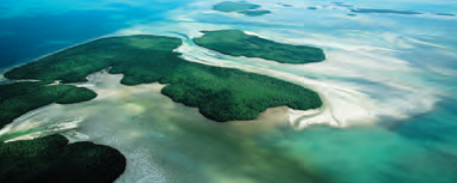
The Florida Keys are a group of coral and limestone islands connected by 42 bridges for over 300km (186 miles).
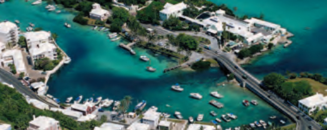
Famous for its shipwrecks, Bermuda consists of seven main islands and over 170 named islets and rocks.