Caribbean: The Lesser Antilles - Insight Guides (2016)
THE BRITISH VIRGIN ISLANDS
Once a pirates’ refuge, today this peaceful archipelago with white powdery beaches washed by crystal-clear waters is a mecca for sailors and divers.
Main Attractions
Soper’s Hole
Smugglers Cove
Mount Sage National Park
Cane Garden Bay
The Baths
Gorda Peak
Bitter End Yacht Club
Prickly Pear Island
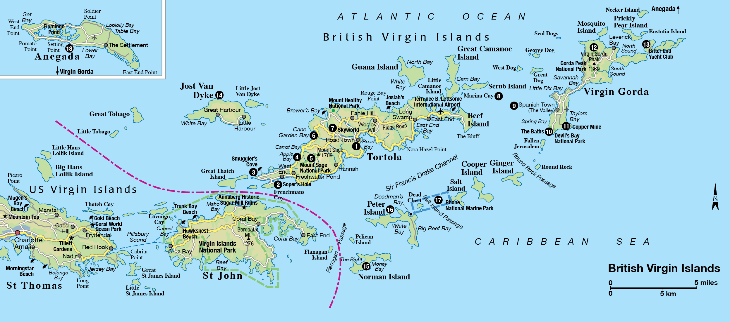
Only a few miles away from the glitz of the US Virgin Islands, the BVI, as the British Virgin Islands are affectionately referred to, do not cater for mass tourism. On the main islands of Tortola, Virgin Gorda, Jost Van Dyke, and Anegada, out on a limb to the north, there are no high-rise developments, flashy hotels, or casinos and most of the other 50-plus islands are uninhabited or have only one exclusive hotel or villa. For a long time, they managed to evade the whirlwind of change that enveloped most of the Lesser Antilles and are now capitalizing on their simple treasures: a pleasant, gentle citizenry and long, unspoiled beaches of powdery white sand bordering clear seas that give new meaning to the word “blue”.
Soper’s Hole, Tortola.
iStock
Here, all the action takes place above and beneath the surface of the water: sailors love the warm breezes that blow them from island to island where they can sample the secret coves only accessible by sea, and divers have a rich underworld of reefs to explore. This natural wealth forms the basis of the islands’ economy and up-market resorts have developed around marinas offering yacht and hotel accommodations combined - it’s the yachties the government wants to attract, along with those seeking somewhere quiet and beautiful to escape to. Up on the mountain slopes, hairy lianas (vines) hang from ancient mahogany trees in snatches of remaining forest.
Little Dix Bay, Virgin Gorda, British Virgin Islands.
iStock
All the islands are of volcanic origin apart from Anegada, a flat coral and limestone atoll 30 miles (48km) northeast of the largest island, Tortola (21 sq miles/55 sq km). Both Tortola and Virgin Gorda, 14 miles (20km) away, rise steeply from the sea, each with a volcanic peak - Tortola’s Mount Sage is 1,709ft (540 meters) and Gorda Peak is 1,369ft (415 meters). Getting anywhere in a hurry on Tortola is impossible. Some of the roads are easily on a par with alpine passes in Europe, with altitude differences of nearly 1,000ft (300 meters) within a couple of miles. The asphalt road encompassing most of Tortola was only completed towards the end of the 1980s; before then, anyone from Sea Cow Bay in the south who wanted to go to Cane Garden Bay in the north went either by donkey or by boat.
Fact
While tourism is the mainstay of the economy, with a growing number of cruise ships calling as well as yachties and land-based holiday-makers, the BVI is also an attractive location for filming. Promoted by the BVI Film Commission, numerous commercials, movies, television shows, and photographic shoots have brought in additional funds to the islands.
Pirate haunts
Christopher Columbus may not have been all that impressed by these seemingly haphazardly located volcanic rocks when he discovered them in November 1493. But who was looking for good beaches at that time? Gold was what he was after, and there wasn’t any. The predominantly steep terrain of Tortola provided the English with a handful of plantations later on, and there were enough fish in the sea to keep the slaves well fed. To protect the plantations and settlements from the incursions of pirates, forts were built along Tortola’s south coast. One famous pirate dropped anchor here on numerous occasions: Sir Francis Drake, for whom the strait between Tortola and the southern islands is named. His fleet was often in the area from 1568 to 1595 to keep the Spanish and Dutch in check, which also entitled the English to plunder their gold. Sometimes the forces of nature helped by dashing the ships on to the reefs north of Anegada - more than 300 vessels lie on the seabed here. Other pirates roamed the southern islands, feeding the imagination of story-tellers for years to come. The BVI have been in British hands since 1666 and today are mainly self-governing as a British Overseas Territory.
The Crafts Market in Road Town.
Getty Images
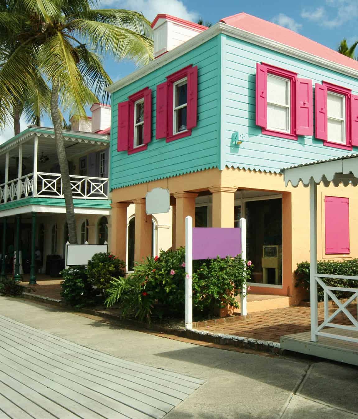
Road Town -Tortola’s capital
The yachting harbor, built around the artificial moles of Wickhams Cay 1 and 2, and the attractive marina beneath the renovated walls of the Fort Burt Hotel to the southwest, have given Road Town 1 [map] a bustling maritime character - “road” is the nautical name for a protected and safe place to drop anchor. Waterfront Drive on the landfill area is a wide road sweeping around the harbor linking the marinas, the government buildings on Wickhams Cay, and the cruise ship landing area.
Palm trees and shrubs are taking root on this once barren area of reclaimed land, and modern structures such as the Government Building came in for quite a bit of stick when first constructed. Caribbean T-shirts emblazoned with tropical patterns dangle from stalls in the Crafts Market close by, alongside colorful fish mobiles, napkin rings, and other delightfully impractical items.
On picturesque Main Street, once the waterfront road, the typical West Indian-style wooden buildings now house banks, insurance companies, boutiques, and souvenir shops. The Virgin Islands Folk Museum (tel: 284-494 3701 ext. 5005; Main Street; Mon-Fri 8.30am-4.30pm; free) documents the colonial era, alongside marine exhibits and Amerindian artifacts in a typical old West Indian wooden building. Near the ferry docks a few minutes’ walk southwards - where boats leave regularly for other islands including St Thomas and St John - Pusser’s Co. Store & Pub, an attractive gingerbread-style house that’s hard to miss, has all the atmosphere of a British harbor pub. This is the place to try the Admiralty Rum, or Pusser’s Painkiller, a notorious rum cocktail, and listen to maritime yarns. Through a door, Pusser’s Store (branches in Soper’s Hole, Marina Cay, and Leverick Bay) provides items with a nautical flavor.
At the bottom of Main Street, fronted by some spectacular flamboyant trees, the smart new government offices overlook the harbor. The Old Government House (tel: 284-494 4091; Mon-Fri 9am-3pm, weekends by appointment) on Waterfront Drive, a national landmark, has been converted from the official governor’s residence into a museum of local history.
The first government house was destroyed by a hurricane in 1924. When government outgrew its replacement (now the museum), a new governor’s office building was constructed on the eastern side of the garden in the 1980s. A new government house was built in the western part of the garden and completed in 2003, with public areas downstairs, and living quarters for the governor and his family upstairs.
To the north of the town, next to the police station, the J.R. O’Neal Botanic Gardens (daily; donations welcome), with an avenue of palm trees, beautifully portrays the various vegetation zones of the islands and includes an orchid house, fern house, and medicinal herb garden.
Fact
The BVI has 21 national parks under the aegis of the BVI National Parks Trust (www.bvinpt.org), protecting areas on land and underwater, including historic sites, bird sanctuaries, tropical forests, whole islands, and a shipwreck.
Tortola’s west end
Winter in the BVI means only a few hours of rain every now and then. It never gets cold or unpleasant; big warm raindrops fall onto the hot ground, and the sun’s rays appear from time to time through dramatic cloud formations. Then in summer the islands look exotic and green. Bougainvillea covers the houses with its magnificent blossoms, and the gardens are full of bright red hibiscus. The marina at Soper’s Hole 2 [map] on Frenchman’s Cay, 8 miles (13km) west of Road Town, Pusser’s Landing, the yacht charter buildings, the galleries, and the shops all combine with the surrounding countryside to create a magnificently colorful scene, especially just before sunset. Ferries to the US Virgin Islands and Jost Van Dyke (for more information, click here), 5 miles (8km) away, leave from Soper’s Hole.
All the beaches in the BVI are public, but you’re certain to find a quiet spot near the elegant hotels in Long Bay at the end of the steep road over Zion Hill. The bumpy track westwards past Belmont leads to Smugglers Cove 3 [map], a delightful sandy inlet with sunshine practically guaranteed until evening, and wonderful snorkeling. Around to the west, dramatic rocks rise from the sea at Steele Point and smart villas decorate the steep slope behind.

Tortola, as seen from the sea.
iStock
Trophies and shells
When Hurricane Luis passed this way in 1995, it seems to have had something of an effect on Bomba’s Surfside Shack, in Apple Bay 4 [map]. In a venue popular with locals, yachties, and surfers jumping the waves in the bay, a few more oddities were added to the collection of trophies plastered over the ramshackle walls: an ancient bra, a pennant from New Zealand, T-shirts and other flotsam, many bearing personal dedications to the shack’s owner. This place has become a real institution and one of the best-known nightspots in the BVI - the “full moon parties” and weekly reggae nights are quite an experience: hips sway amidst the barbecue smoke, and the fun spills out on to the road.
At the other end, in Carrot Bay, a more traditional collection can be seen at the North Shore Shell Museum Bar & Restaurant where, after a drink or a meal of cracked conch, grilled lobster, and good Caribbean cooking, you can see exhibits of local crafts alongside the countless shells.
Blooms of the heliconia genus.
iStock
Panoramic hairpins around Mount Sage
The coast road winds up from Carrot Bay along spectacular Windy Ridge toward Cane Garden Bay and branches off into Mount Sage National Park 5 [map], a protected area of tropical forest spared from clearance in the plantation era. Giant mahogany trees with complex roots cling on to the rock face of the 1,709ft (543-meter) Mount Sage, and lianas, moss, and numerous orchids leech moisture from tree trunks and hollows; tree frogs start their chorus just before sunset. As water takes longer to seep through volcanic rock than through limestone, the vegetation grows profusely here on an annual rainfall of less than 12ins (30cm).
Rum plays a major role in the BVI, but much of it actually comes from other islands. There were once seven family-run firms producing the “liquid gold” in Cane Garden Bay 6 [map] but now only the fine Arundel Cane Rum is produced at the 200-year-old tumbledown Callwood Distillery (tel: 284-495 93 83; Mon-Sat 7.30am-5pm; free). The secret of the rum’s high quality, according to owner Michael Callwood, is that it is made from the sugar-cane juice rather than the molasses left behind in the sugar refining process.
Tip
The best surfing can be experienced from November along Tortola’s north coast at Apple Bay, the eastern end of Cane Garden Bay, and Josiah’s Bay.
The gently curving bay in front is one of the Virgin Islands’ top beaches: deckchairs and sunshades are for rent, yachts move slowly past buoys on the turquoise sea, all types of watersports are on offer, and calypso bands strike up outside the bars just before sunset. Brewer’s Bay farther north is far more provincial: the sand is much darker, and don’t be surprised to see the odd cow walking across it. The roads around here are very steep and signposts point to the ultimate viewing spot at Skyworld 7 [map] on Ridge Road where there is a 360-degree panoramic view of Road Town, surrounding islands, and the rolling hills to the east: a perfect place for a picnic before hitting the challenging mountain road once more to Long Swamp and East End, 7 miles (11km) away. From there turn steeply northward and over the summit to the Lambert Beach Resort where, with a drink on the terrace, you can gaze in wonder at the creamy white beach edged by palms and ancient seagrapes around Elizabeth Bay.
Fact
Every March the BVI Spring Regatta & Sailing Festival (www.bvispringregatta.org) attracts around 100 yachts and sailors from all around the world. Participants enter in 18 classes and race in three race areas, and the weeklong event, starting at Nanny Cay, is accompanied by fantastic Caribbean parties. In 2016 the regatta celebrated its 45th anniversary.
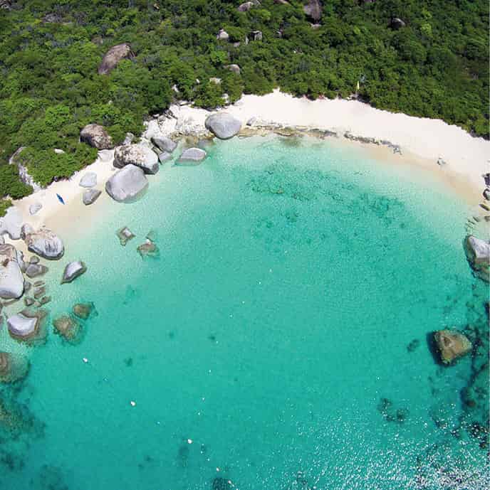
Aerial view of Devil’s Bay, Virgin Gorda, British Virgin Islands.
iStock
Beef Island, where the Terrance B. Lettsome International Airport is sited, is connected to East End by the Queen Elizabeth Bridge. Off the coast, the tiny 6-acre (2-hectare) island of Marina Cay 8 [map], only slightly higher than the surrounding coral, looks as if it could easily disappear under a large wave. Free ferries ply to and from the island, 5 minutes away, around 10 times a day from Trellis Bay, just east of the airport and a popular windsurfing spot. Once owned by the author Robb White, who used it as the setting for his book Our Virgin Isle and the film version Two On The Isle with Sidney Poitier in the 1950s, Marina Cay is now a private resort belonging to Pusser’s and offers a wide variety of water sports such as snorkeling, underwater safaris, kayaking, and deep-sea fishing.
The fat Virgin and her giant “marbles”
If Columbus had been thinking of St Ursula and her 11,000 virgins when he named this archipelago, why should a granite island have been named Virgin Gorda (Fat Virgin)? Speculation abounds, one notion being that, from afar, the 10-mile (16km) long island looks like a reclining woman with a protruding stomach. Spanish Town 9 [map], also known as The Valley, is the main town on Virgin Gorda and until 1741 was the capital of the entire group of islands. The houses are dotted across various parks and gardens, and souvenir hunters will find a handful of colorful boutiques near the modern and well-equipped Yacht Harbour, south of the ferry dock.
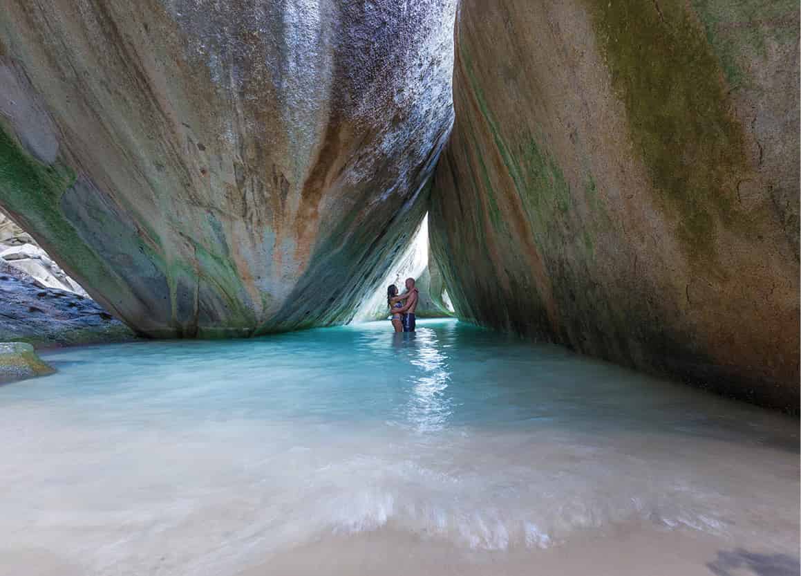
The Baths, Virgin Gorda.
iStock
From here taxis can take you across the southern part of the island past huge rounded granite blocks looking like giant marbles scattered all over the place, to The Baths ) [map], where the house-high boulders have formed natural grottoes and pools perfect for swimming and snorkeling. There’s an easy trail between them, with ladders and bridges over the tricky parts. Geologists refer to this phenomenon, which is part of the Devil’s Bay National Park, as “woolsack weathering” - long ago, a thick layer of soil covered the stone, and acids from the humus gradually worked their way into hairline fissures in the rock, wearing it away. As the topsoil gradually disappeared, wind, heat, and salt particles continued to erode the rough granite so that some look as if their shells are about to break.
Noticing that the granite southeastern coast of Virgin Gorda was similar to that of Cornwall, where copper mining was a lucrative industry in the early 19th century, the British speculated that there must be some copper here too. They were right, and Cornish miners worked the Copper Mine ! [map], not far out of Spanish Town, for around 30 years. The chimney of the old mine, ruins of old stone buildings, a copper-ore pit, and remains of a smelting furnace can all still be seen.
Yachting in the north
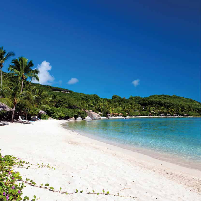
Just 5 minutes north of Spanish Town lies Little Dix Bay, where in 1964, after his success with Caneel Bay Resort in St John (for more information, click here), Laurance Rockefeller opened the BVI’s first hotel, geared expressly toward family vacations, and put Virgin Gorda on the map.
At the narrowest point of the island, less than 980ft (300 meters) of land separate the spray-covered coast to the east from gorgeous Savannah Bay. On weekdays this coastline is like one long private beach - all yours. The road continues north, branching off to Gorda Peak @ [map] (1,369 ft/417 meters), a National Park where the views from the observation point, reached after a short walk through some protected mahogany forest, are quite dizzying. Then it’s downhill all the way to the happy and colorful Pusser’s hotel at Leverick Bay.
Tip
Sailing, kiteboarding, and windsurfing courses for all ages are available from the Bitter End Sailing School at Bitter End Yacht Club (tel: 284-494 2746) and you can also learn about live-aboard cruising (www.beyc.com).
The North Sound Express launch stops off at the hotel on its 45-minute journey from Tortola across the deep water of the North Sound to the Bitter End Yacht Club £ [map] at John O’Point. Here the yachties rule and the beach and water sports facilities are awe-inspiring. Instead of staying in any of the discreet-looking villas dotting the hillside or next to the beach, you can spend your holiday on one of their 30ft (9-meter) yachts.
On the northeastern edge of North Sound lies Prickly Pear Island, which has a beautiful long white beach at Vixen Point, with the Sand Box beach bar. The island is a National Park, home to resident and migratory birds, and there is a trail from the beach bar to North Beach. No ferries stop here, so you must have your own boat.
Jost Van Dyke - a tranquil retreat
The moment the speedboat to Jost Van Dyke $ [map] from Soper’s Hole has docked, all the passengers disappear into Great Harbour except for the tourists, who stand gazing around them in astonishment. Time seems to stand still here: a handful of houses in a bay, and green hills under a scorching sun - indeed, electricity was only brought to the island in 1991. A few people stand in front of the Customs House, and goats graze peacefully in the cemetery. A pink sign bears the words “water-taxi” together with a phone number. What on earth do people spend their time doing here? Some, such as Foxy in his beach bar, have become accomplished storytellers.
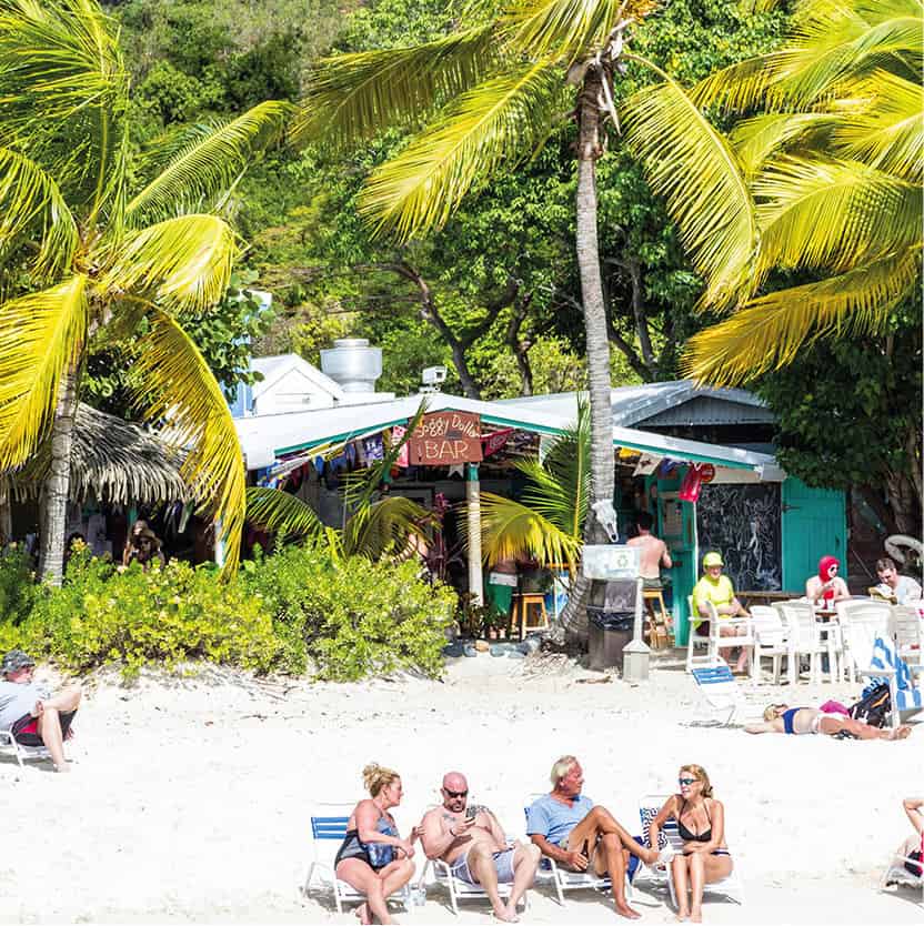
The world-famous Soggy Dollar Bar on Jost Van Dyke, British Virgin Islands.
iStock
The water-taxi quickly takes you westward round to White Bay where you have to paddle barefoot through the waves to the beach. Pant and dress hems get wet, but dry out again almost as quickly while you’re lying in the hammocks among the palm trees at the aptly named Soggy Dollar Bar. Every day feels like Sunday here. The atmosphere is perfect, and so romantic that it is almost a cliché: palm and seagrape trees, ultra-fine sand, gentle hills on the southern horizon, and all of it at the place where a painkiller cocktail (Pusser’s Painkiller) was supposed to have been invented. What ailments needed to be cured in this paradise? Surely it can only have been the pain of having to leave.
Treasure islands
Forming the southern edge of the Sir Francis Drake Channel, south of Tortola, is a collection of tiny islands that provided perfect hiding places for pirates and inspired romantically inclined 19th-century authors such as Robert Louis Stevenson (1850-94). This Scottish novelist and poet is supposed to have chosen the uninhabited Norman Island % [map] as the location for his Treasure Island (1883), and treasure hunters have done a great deal of digging ever since, to no avail. The real treasures, however, are under the water around the reefs of the protected bay known as The Bight which are bountiful in colorful fish; the caves along the rocky west coast, reached by boat, offer snorkelers a magnificent show.
When it’s time to come up for air, cold drinks and Caribbean food are served up by the galley team on the William Thornton II (tel: 284-496 8603; VHF channels 16 or 74; www.williamthornton.com), a replica of an old Baltic trading vessel, in The Bight. More underwater caves and reefs give divers and photographers a fascinating few hours around Pelican Island and the pinnacles of rock called The Indians.
Despite the name, Deadman’s Bay on the north coast of Peter Island ^ [map] is often ranked as one of the top romantic beaches in the world - a white-sand beach fringed with palm trees and lapped by a gentle turquoise sea has to be irresistible. Cacti and enormous agaves cover the island, owned by the environmentally conscious Peter Island Resort. Gold-medal-winning chef Alson Pont’s Caribbean specialties can be sampled at the beach restaurant.
With a view of Dead Chest, where the pirate Blackbeard is said to have left 15 sailors to die - “Fifteen men on a dead man’s chest/ Yo ho ho and a bottle of rum” - the diving boats set off toward the buoys surrounding the RMSRhone in the Rhone National Marine Park & [map]. In 1867, this 320ft (100-meter) long Royal Mail vessel sank just to the west of Salt Island during a hurricane. One passenger and 20 crew members were rescued and to thank the Salt Island rescuers, Queen Victoria gave them ownership rights to it in return for one English pound of salt a year.
The Dog Islands
The Dog Islands are a collection of tiny islets 2.5 miles (4km) northwest of Virgin Gorda. They got their name because sailors who anchored there heard barking and thought there were dogs on land. They soon discovered, however, that the noise came from barking Caribbean Monk seals, which they promptly caught and ate. Now, the islands are a stopping place while sailing from North Sound to Jost Van Dyke, and are popular with divers for the canyons and bridges underwater, as well as other interesting rock formations. Great Dog is the largest island, followed by West Dog Island and George Dog Island. There is a sub-grouping of Seal Dog Islands, off Great Dog Island, the smallest of which delights in the name of Cockroach Island.
Several of the boats that take divers out to explore the colonies of coral and sponge fore and aft of this ship - which lies 70ft (20 meters) below the surface and has an enormous propeller - dock at Salt Island. The last resident and salt-gatherer died in 2004 and is buried on the island.
Anegada - an island of beaches and wrecks
The flat island of Anegada * [map] is easy to overlook, at 11 by 3 miles (17 by 5km), its highest point being a mere 28ft (9 meters). But, with a continuous white beach from the Anegada Reef Hotel in the south, round West End along the north shore, where turtles nest, to East End, it would be a mistake if you did. For snorkelers, the reef offshore contains caves, drops, and tunnels awash with colorful fish and turtles. Farther out, beyond the reef, scuba divers can explore several wrecks, home to angelfish, stingrays, and grouper. Fishermen still provide the hotel with the best lobster in the BVI - it’s also a top spot for bone fishing.
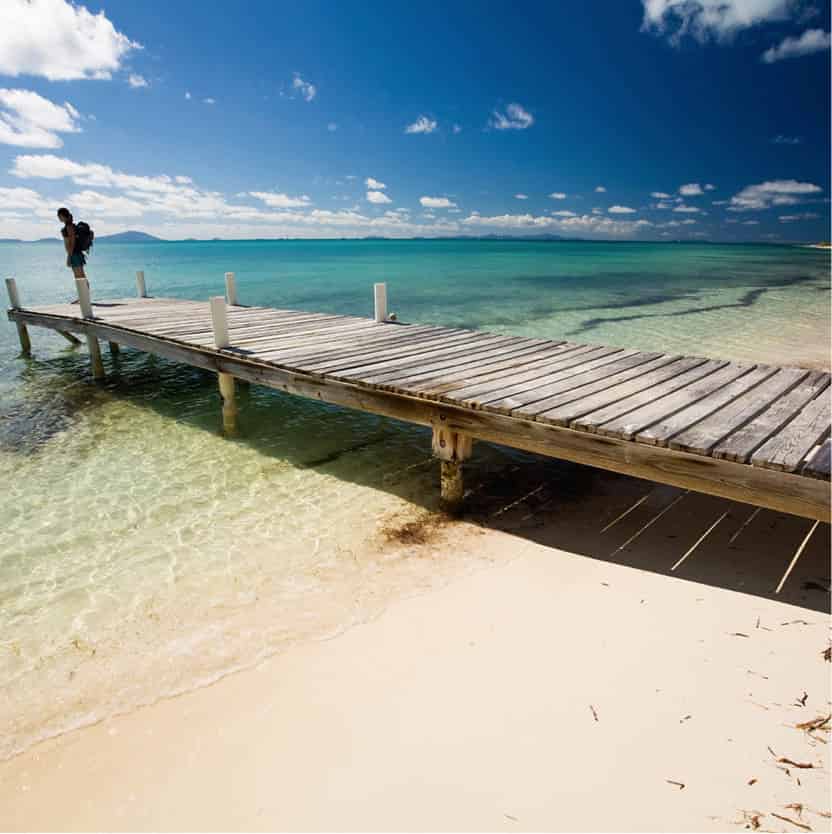
A wooden dock at Anegada.
iStock
Fact
British entrepreneur and head of the Virgin empire Sir Richard Branson couldn’t resist the idea of owning a Virgin Island and he famously owns Necker Island and Moskito Island, north of Virgin Gorda. Luxury houses have been built on both islands which are available to rent at luxury prices (www.virginlimitededition.com).
Two short strips of tarmac meet up in The Settlement, where most of the 300-strong population live. The controversial decision to introduce flamingos to the lagoon in 1992 proved a success when wild ones joined them and they reared some young. Anyone just here for a day would do well to hire a jeep to visit Loblolly Bay, on the north coast, which is flanked by two bars.