Krakatoa: The Day the World Exploded: August 27, 1883 - Simon Winchester (2003)
Chapter 3. CLOSE ENCOUNTERS ON THE WALLACE LINE
Southeast Asia is probably the finest natural geological laboratory in the world… It is a spectacular region in which the manifestations and processes of plate collision can be observed at present and in which their history is recorded. It is a region which must be understood if we are to understand mountain belts, arc development, marginal basin evolution and, more generally, the behaviour of the lithosphere in collision settings… Furthermore the region is developing rapidly…
- from the introduction to Tectonic Evolution of Southeast Asia, R. Hall and D. J. Blundell (eds.), London, 1996
1.Delineation
On a bleak December evening shortly before Christmas in 1857, in the severely elegant lecture theatre of what was then biology's sanctum sanctorum, the Linnean Society in Burlington House on London's Piccadilly, a young man named Philip Lutley Sclater rose to present a paper that, though all but overlooked by most biologists today, was to lead steadily to a revolution in scientific thinking about the history of the world.
Philip Sclater may have been only twenty-eight years old when he stood before the assembled worthies, but already he had won an awesome reputation. He had been to Winchester and Christ Church, Oxford, and was inordinately clever. He was unusually well travelled (Argentina, Malaysia, India, Australia and most of the states of America), and was both a superb artist and - the basis of his near-legendary reputation among his few followers today - a brilliant ornithologist.
He specialized in the exotic, the colourful, the tropical, the odd. He came to know all there was to know about the South American finch-like birds called tanagers and the country neighbours of theirs that were called ovenbirds, because they built their nests out of clay in the shape of ovens. He would write definitive books about Passeriformes, that huge class of rather less unusual perching birds; he had a lark named after him; he founded the British Ornithologists' Club and was for many years secretary of the Zoological Society of London. And he gave the name Lemuria* to a landmass he believed (wrongly) had in Eocene times connected the Malayan peninsula with Madagascar, and on the remaining peaks of which now sits the enormous mid-Indian Ocean, British-owned and American-leased military base of Diego Garcia.
Crucially for this Krakatoa story, Philip Sclater was also a specialist in a new science that was growing apace during late Victorian times, and that has been called variously either biogeography or zoogeography. As more and more specimens of animals, insects, plants and birds were collected, classified and catalogued, so it became steadily more apparent that geography had a major influence on zoology and botany - that certain living creatures were peculiar to certain parts of the world and not merely to certain climatic zones. One might find precisely the same climate in Uganda and Queensland, for example, but because Africa and Australia were so far away from each other, their native inhabitants had developed without ever making contact with one another. In the same way their flora and fauna were now entirely separate, different and peculiar to each of the two places. The polar populations are another obvious example of zoogeographical reality: polar bears and people inhabit the north, penguins and albatrosses the south, even though the climatic environment in each place is essentially identical.
The birth of the study of such regional differences in populations of plants and animals - of the biota, to use the proper if rather unattractive word - was a natural by-product of the frenetic pace of exploration of the time; and Dr Sclater, an explorer of the old school, had by the middle of the nineteenth century a keenly developed interest and expertise in the topic.
The paper he presented to the Linneans that winter's night was on precisely this subject: ‘On the General Geographical Distribution of the Members of the Class Aves’, with a particular interest ‘in the islands around New Guinea’. And Sclater offered what to his listeners was a remarkable and startling discovery. He had observed what seemed to be a rigid zoogeographical distinction deep within the islands of the East Indies.
The kind of dramatic geographical variation that might be seen on the two sides of a vast body of water - the measure of difference between African birds and Brazilian birds, for example, separated by the whole of the South Atlantic - might not be expected within the continuum of an archipelago as closely knit as the East Indies. But here, astonishingly, there was. In months of research that took him right along the 2,000-mile volcanic chain stretching from Sumatra to the Trobriand Islands, Sclater found the occurrence of a huge, unanticipated and very sudden change: the jungles in the west of the archipelago, for example, sported birds that were akin to those found in India, while those to the east of a vaguely imagined line were alive with an avian fauna that was to be found only in Australia.
Sclater had not completed enough research to be able to draw a firm demarcation line between the two populations. All he could say for certain was what he had seen. Certain birds - say, parrots - found in wild abundance in the eastern, Australian end of the archipelago were, quite literally, rarae aves on the western, Indian side. There are barely any parrots on Java; but there is every imaginable kind in Sulawesi, Irian and Timor. Not a single cockatoo is to be found in the west; but two entire families each of cockatoos and lories - this last a kind of parrot with a brush-like tongue - are found in the east.
Barely any thrushes are to be found on the islands to the east of Bali. In the western half of the archipelago there are woodpeckers, barbets, trogons, paradise flycatchers and paradise shrikes, minivets, blue drongoes, pheasants and jungle fowl - but none of these, just like the humble thrush, is to be found in the east. The forests of this eastern end of the chain, on the other hand, are populated uniquely with legions of showy and exotic birds that one might just as easily find in Queensland and New South Wales: honey-suckers and birds of paradise, cassowaries and emus.
Any traveller with half an eye and half an ear open will realize simply from the colours and the birdsong that something profound is going on. In making an eastward journey from Sumatra to Irian, though he may not once pass out of sight of land, the traveller will have most decidedly left one world and entered another one utterly different.
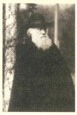
Alfred Russel Wallace.
It would be forty more years before Sclater, working then with his son, would draw a map with the formal delineation, as the pair saw it, that separated the two avian worlds. But his work, which culminated in the reading of his 1857 paper outlining but not quite delineating their meeting-place, excited the interest of a much older, bolder and less well-educated Briton who was then living in the Indies. It was Alfred Russel Wallace who came swiftly to understand that it was not simply birds who inhabited two quite different worlds: plants and animals did also. And, just like the birds, they all met - collided, even - somewhere among the maze of jungles of the myriad islands of the Dutch East Indies.
Alfred Russel Wallace - who at the time was collecting, studying and living on the spice-rich island of Ternate in a grass hut - would take the observations of this young naturalist and, adding a vast amount of information from his own observations and collections, transform them into a theory and a grand cartographic creation that would survive to this very day. It has a name that remains its architect's most familiar memorial: the Wallace Line.
Philip Lutley Sclater, learned, patrician and well connected, might have thought he had some vague right to have this 2,000 miles of tracery named after him, in recognition of his pioneering work on the region's bird-geography. But the honour was eventually to be given to his very much more capable successor, the lowly born, hugely tall genius from the town of Usk in south Wales, remembered today mainly for having imagined and then drawn this vast and invisible line in the sea. Mainly, but not solely: Alfred Russel* Wallace has a trench off Java named after him too, as well as a 13,300-foot peak in the Sierra Nevada, a garden in Wales, an aviary in Bristol, a bird of paradise, biology prizes in both Kansas and Australia, countless lecture theatres and university halls, and craters on both Mars and the Moon.
Whoever named a lunar crater in his honour was a man with a mordant wit, or an ear for the laboured pun. For many years Wallace had been known, perhaps more widely than anything else, as Darwin's Moon† - the lesser body that was bound by the Fates to dance in constant attendance around the orbit of the greater. For although the Wallace Line has yet some importance, and though it has a singular connection to this story of Krakatoa, any account of Wallace himself must make mention of the more important reasons for such fame as he still has - and that is that Alfred Russel Wallace, alongside Charles Darwin but always as his satellite, is the other true but largely unremembered pioneer of the science of evolution.
His birth in Usk in 1823, as the seventh child of a librarian, was into a threadbare but intellectually respectable family. He started his own life as a Leicestershire schoolteacher, but one whose life was marked from the start by passionate fascinations - in this first case, with the life and times of the Coleoptera, those insects with hard coverings for their flight wings that are generally and more prosaically known as beetles. He was also interested in spiritualism, and indeed rediscovered this fascination much later in his life; mercifully for the advance of science, his dabblings into what he called ‘phreno-mesmerism’ were suddenly nudged back towards worthier pursuits when he stumbled upon a similarly insect-captivated city lad, a hosier's son and sometime warehouse-sweeper named Henry Walter Bates.
This pair, soon inseparable, hunted, collected and catalogued beetles in every corner of Leicestershire and points beyond - with Bates publishing his first paper ‘On Coleopterous Insects Frequenting Damp Places’, the title telling us perhaps more about Leicestershire than about beetles.
In 1848, three years after meeting and having exhausted the coleopterous delights of the meadows and damp places of the Midlands, this pair of redoubtable young men combined what little savings they had to begin a remarkable scheme: to go off specimen collecting in the wilds of the beetle-rich, insect-rich Amazon rain forest.
For Bates it was the beginning of a lifelong love affair with what he called ‘the one uniform, lofty, impervious and humid forest’, a love affair that started in the remote Brazilian jungle village of Ega, 1,400 miles upriver. During the six years he lived there he collected and named no fewer than 550 new and distinct species of butterfly (at the time only sixty-six were known throughout the entire British Isles). He travelled thousands of miles in the deepest and most remote corners of the forest, and over the years became a world authority on insect mimicry; and, together with his friend Wallace, ultimately came to be an instigator of the theory of natural selection and an unalloyed supporter of Charles Darwin once On the Origin of Species had been published in 1859.
For Wallace, however, the journey to Amazonia was just the start of a fascination that soon ranged around the entire world, but that is most closely associated today with the region he found the richest and most intellectually satisfying: the then Dutch East Indies. Yet his interest did not properly begin until he had been severely tried and tested on his way home from Brazil: the square-rigger Helen, in which he was bringing home his valuable collections of Amazon specimens, caught fire and sank in mid Atlantic, and Wallace spent ten days in a longboat before being picked up near Bermuda. He wrote two books on his experiences. Darwin, who trawled through both looking for evidence to bolster his own fast-coalescing ideas on biological variation, natural selection and species origin, found them frustrating. ‘Not enough facts,’ he harrumphed, cruelly unaware that Wallace had lost not only his notes but his specimens, all gone down with the foundered ship.
In 1854 Wallace set off, alone, for the East Indies - the chain of islands that he, as a geographer, preferred to call the Malay Archipelago, since the thousands of islands were indeed a classic example of an archipelago, and the islands' lingua franca was, in most cases, and to a greater or lesser degree, based on Malay. His keen conviction remained, for all the eight years that he spent there, that evidence to be found in this archipelago would substantiate his two growing beliefs: that geography was highly influential in the development of biology, and that species originated by the natural selection of favoured types from within the variations of any population. He spent the better part of his life seeking to prove both points - and by and large (and in the penumbra of Charles Darwin) he succeeded magnificently.
His collecting zeal was prodigious. He sent back to London, or eventually came back with, a meticulously organized collection of no fewer than 125,660 specimens of the plants, animals, insects and birds of the islands. There were 310 mammals, a hundred reptiles, 83,000 beetles (not surprisingly), 13,000 other insects, 8,000 birds, 13,000 butterflies and 7,500 shells. His study of this vast number of living things brought him to both of the epiphanies that he had sought, and at almost the same moment. He suddenly realized evolution's existence and mechanism, and he immediately recognized the profound difference between the two basic animal and plant populations of his chosen archipelago, and he realized and recognized these two profundities at essentially the same time: during what for Wallace were the seminal and intellectually furious years of 1858 and 1859.
Wallace's sudden understanding of evolution is one of the most romantic tales of modern science, ranking with the sudden achievements of Archimedes and Galileo, Becquerel and Newton, Fleming and Marie Curie. The vision came to him not in a bathtub, or in Pisa, or on a Paddington windowsill, or under an English apple tree - but in a grass hut on stilts, in a village on the island of Ternate, during a bout of jungle fever. There are not a few who believe that it is the Spice Islands, and not the Galapagos, that one day should come to be recognized as the true birthplace of the science of evolution.
At the time, thousands of miles away in Kent, Charles Darwin was working, with painstaking tardiness, on what he called his ‘big book’. He knew he was on to something. He had the core of an idea as to how and why new species evolved. He had the facts at hand. He had collected his own beetles; he had bred pigeons; he had observed and measured and catalogued the tens of thousands of living creatures from his years aboard HMS Beagle. And he was well aware of Alfred Russel Wallace - not least because in 1855 Wallace, then in Sarawak, wrote a paper entitled ‘On the Law which has Regulated the Introduction of New Species’, which argued that new species arise from within variations in a population that is somehow (as he was so often seeing in the East Indies) geographically isolated from other populations of the same creatures. The paper presented only an incomplete theory,
Charles Darwin.
and it presented no mechanism for this introduction of new species - but it set Darwin once again to pondering, ruminating and (for which he is well known) procrastinating.
And then, just after New Year's Day in 1858, Wallace arrived in those eastern islands that the Dutch called the Moluccas (or Maluku, as they are once again today). During the intervening three years of wanderings between Sumatra and Irian he had had his full share of excitements: headhunters had severely scared him on the island of Lombok, his arms and legs had been badly infected by leeches and biting insects, he had found a ten-foot snake in the ceiling of his hut on Ambon, he had suffered from unremitting dysenteric fever, and he had contracted case after case of malaria. Indeed, it was a particularly nasty attack of this, caught when he was on a brief insect-collecting trip to Halmahera, that prompted him to go back to his little house on Ternate at the end of February. He sat and perspired and wrote and pondered and ruminated - and then, in one of those fascinating manic moments of fever-induced excitability, he suddenly got it.
While wondering yet again what it might be that caused the break between one species and the success of a specialized variety that would lead to the creation of a wholly new species there suddenly flashed upon me the idea of the survival of the fittest - that the individuals removed by these checks must be, on the whole, inferior to those that survived. Then, considering the variations continually occurring in every fresh generation of animals or plants, and the changes of climate, of food, of enemies always in progress, the whole method of specific modification became clear to me, and in the two hours of my fit I had thought the main points of the theory. [My italics.]
Wallace wrote this account in his book The Wonderful Century a long while later, which might prompt some suspicions. But any doubts about the legitimacy of his claim to be the first to recognize both the idea and the mechanism of evolution must be allayed by his having immediately written a paper and dashed off a letter to Down House - asking Darwin to forward it for possible publication to the geologist Charles Lyell, whom Wallace thought he had better impress. It was Darwin who was impressed. The Wallace paper was, he later said, ‘a bolt from the blue’. It deeply disturbed him. It was the very idea for which he was looking. It provided the jolt he needed to get on and finish his big book. And when he did, and the book appeared under the now-famous title On the Origin of Species, Wallace's crucial references to ‘the struggle for existence' and the ‘survival of the fittest' appear as the keys to the entire mystery.
Charles Lyell and Joseph Hooker persuaded Darwin to share at least some of the glory with Wallace, far away, low born and an upstart though he may have been. The formal announcement that the puzzle at the root of the science of evolution had now. been cracked was made at the meeting of the Linnean Society on 1 July 1858: it was a joint announcement, made by the introduction of papers by Darwin and Wallace - with Darwin admitting, somewhat lamely, that though he had had the very same idea as Wallace some days before, he had never committed it to paper. Procrastination had done for him.
But not, it seems, for his reputation. Darwinism is the accepted word, invented by Wallace and the title of one of his later books. Wallace never displayed in public a scintilla of bitterness, and contentedly and generously gave Darwin all the credit. His classic, The Malay Archipelago (in which Wallace tried to popularize the idea of a zoogeographical division, which so neatly coincides with the phenomenon that gives birth to Krakatoa), is dedicated to Darwin, ‘to express my deep admiration for his genius and his work’. He remained loyal, almost servile - the ever revolving little moon around Darwin's glittering and far grander planet.
He did not receive a knighthood, as did so many of his more nobly born contemporaries, like Galton, Huxley, Lyell and Hooker. He did, however, become a member of the Order of Merit, which many in Britain think more worthy. His public standing then went into a long and slow decline, and outside Indonesia, where he is still well known, he has until lately been little recognized in the world.
Perhaps his spell in history's wilderness is now coming to an end. In April 2000 his grave in Dorset was refurbished;* and in November 2001 a plaque was unveiled in what is now the Royal Society's Reynolds Room, noting that a century and a half beforehand the papers of Charles Darwin and Alfred Russel Wallace had been read there, which formally set in motion a whole new science of evolutionary studies.
In recent years there have been kindly new biographies of Wallace, new studies of his contributions to science, fresh examinations of the papers of Darwin, Lyell, Hooker and all the others involved in the evolution of evolutionary thinking. There seems in consequence a growing sympathy these days for the idea that Darwin may have behaved less than fairly to the man who had the same idea as he had, and at the very same time - but who had the misfortune of writing everything down almost immediately and shouting the news from the rooftops, of being less gently born and less well connected than the master of Down House, and of spending his declining years more interested in eccentric sciences, out on the fringes of respectability. To some these days, the idea that Wallace's only memorial is merely a line that passes unseen across the sea seems a melancholy insufficiency for all of his many achievements and ideas.
The Wallace Line, however invisible and however controversial (in later years, because of technical arguments among the world's community of zoogeographers), does at least have the merit of being directly relevant to both the makings and the violent unmakings of Krakatoa. It may have played only a marginal role in the development of the theory of evolution of life. But it does play, if unwittingly, a very significant part in the much newer theory of plate tectonics, the evolution of the earth.
Wallace's ideas about it were first made public at the Linnean Society on 3 November 1859 - seventeen months after the famous Linnean Society presentation on evolution and, as then, while he was 5,000 miles away from Burlington House. (He was in Ambon at the time, just back from a half-year in Sulawesi spent indulging in what he incautiously regarded as the ‘capital sport’ of shooting birds of paradise. He was coming under considerable pressure from his family, who had not seen him for five years, to return home. But he said he felt completely happy and at home in the islands, and was not to come back to England until 1862.) His observations of the distribution of the archipelago's immense stock of animals reflected precisely Philip Sclater's findings on the distribution of birds: the representatives of the Australian kingdom of animals lived in the more easterly islands, and the members of the Indian families to their west.
He was able to show, for example, that in the west there were apes and monkeys: there were none in either Australia or the
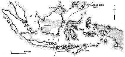
The Wallace Line - Australian fauna (cockatoos, kangaroos) to its east, Indo-European thrushes, monkeys and deer to its west.
Australian-influenced eastern part of the archipelago. Flying lemurs, tigers, wolves, civets, mongooses, polecats, otters, bears, deer, cattle, sheep, tapirs, rhinoceros, elephants, squirrels, porcupines and scaly anteaters were also in the west - and these weren't native to Australia (or, it almost goes without saying, to New Zealand, which was so isolated for so long that it had no native mammals or snakes at all) or to the eastern islands.
Out in those eastern groups, though - where the cloves and nutmegs grow in wild profusion - there were all manner of animals wonderfully unfamiliar to the newcomer from Usk. These included kangaroos, opossums, wombats and the duck-billed platypus. Not an ox or a squirrel, an elephant or a tapir on any of these islands - but instead animals that raise their young in pouches, or hop, or live half in and half out of water, have webbed feet, lay eggs and suckle their young, and flightless birds, and cockatoos.
Alfred Russel Wallace enjoys such fame as he has because he observed all of this bewildering profusion with great care, noted with exactitude where each animal or bird lived - or, just as important, did not live - and then drew a long and sinuous line that separated these two very distinct biological regions. The line, which was announced to the Linneans in 1859 and refined in a more substantial speech in 1863, wandered in an approximately north-east to south-west direction. It began to the south of Mindanao, the most southerly of the main Philippine Islands, and snaked to the north of the oddly shaped island now known as Sulawesi, but which was then called the Celebes.* It then swept south through the Strait of Macassar, leaving Borneo on its western, Indian side, and then headed across the Java Sea to the tightest-imaginable division: the 15-mile-wide and very deep strait between the islands of Bali and Lombok.
The contrast is nowhere so abruptly exhibited as on passing from the island of Bali to that of Lombock, where the two regions are in closest proximity. In Bali we have barbets, fruit-thrushes, and woodpeckers; on passing over to Lombock these are seen no more, but we have an abundance of cockatoos, honeysuckers, and brush-turkeys, which are equally unknown in Bali and every island further west. The strait here is 15 miles wide, so that we may pass in two hours from one great division of the earth to another, differing as essentially in their animal life as Europe does from America. If we travel from Java or Borneo, to Celebes or the Moluccas, the difference is still more striking. In the first, the forests abound in monkeys of many kinds, wildcats, deer, civets and otters, and numerous varieties of squirrels are constantly met with. In the latter none of these occur; but the prehensile-tailed opossum is almost the only terrestrial animal seen, except wild pigs, which are found on all the islands, and deer (which have probably been recently introduced) in Celebes and the Moluccas.
What Wallace realized well at the time was that the reason these two biological regions had so nearly merged and yet had remained so distinct was entirely due to geology. ‘Facts such as these can only be explained by a bold acceptance of vast changes in the surface of the earth,’ he writes, and goes on to speak of a ‘great Pacific continent’ that had ‘probably existed at a much earlier period’. He talks vaguely of submergences and break-ups of masses of land into islands, and other devices that may have caused animals to have existed in isolation and then to have become near, but separated, neighbours.
Four years later, when he presented a much longer paper on the same topic, Wallace was clearly excited, trembling on the brink of a bold new idea.
The nature of the contrast between these two great divisions of the Malay Archipelago could best be understood, he might have said to himself, by considering what would take place if any two of the primary divisions of the earth were brought into equally close contact. Africa and South America, for example, differ very greatly in all their animal forms. On the African side, we have baboons, lions, elephants, buffaloes and giraffes; on the other, American side, spider-monkeys, pumas, tapirs, anteaters and sloths; while among birds, the hornbills, turacos, orioles and honey-suckers of Africa contrast strongly with the toucans, macaws, chatterers and humming-birds of America.
But, he continued to suppose, let us endeavour to imagine that a slow upheaval of the bed of the southern Atlantic takes place, and that earthquake-shocks and volcanic activity on the landmasses on each side of the ocean cause increased volumes of sediment to be poured down the rivers, such that the two continents gradually spread out by the addition of newly formed lands. As a result of these two slow processes, he went on, the Atlantic, which now separates Africa and South America with its thousands of unbridgeable miles of water, would be reduced to an arm of the sea no more than a few hundred miles wide. At the same time we may suppose islands to be upheaved in mid channel; and, as the subterranean forces varied in intensity and shifted their points of greatest action, these islands would sometimes become connected with the land on one side or the other of the strait, and at other times be separated from it. The barrier of the ocean all of a sudden would cease to be a barrier at all…
He was floundering here, becoming nervous and stutteringly prolix, knowing only that somehow he was on the verge of something, some explanation, some answer to the question posed by all he had seen. Yes, indeed - some geological process, some series of events that had something inexplicable to do with movement and submergence and upheaval and spreading and uplift and earthquakes and volcanoes (for he was a keen and sometimes very frightened observer of these in his beloved archipelago), had caused this curious avian and zoological division. But as to what: we can almost see Wallace dabbing the perspiration from his brow, as he omits to follow through, as his thinking draws to a halt, as he fails to come up with the solution, well aware none the less that the answer he seeks is out there, but has proven too elusive for him, this time around.
What Wallace was never to realize was that the mechanism driving all the geology was, in due course, going to be recognized as the then entirely unimaginable process of plate tectonics. And of what he had not the least inkling was that the tectonic collision that had brought his animals and birds together, brought the cockatoo so close to being snared by the squirrel, and the retro-mingent tapir so near to encountering the web-footed monotreme more familiarly known as the platypus, was the selfsame collision that had brought about Indonesia's reputation as the volcanic cockpit of the world, with its notoriously dangerous volcano, Krakatoa, a classic of the kind.
Alfred Russel Wallace knew none of this. But his papers, discoveries and still surviving Line prompted others to begin thinking and pondering too, and to start asking why this encounter between the animals and birds of Asia and the animals and birds of Australia might have happened and, much more importantly, since it evidently had happened, just how?
The scientific world of the time was in the midst of a terrible ferment, with discoveries and realizations coming at an unseemly rate. To many in the ranks of the conservative and the devout, the new theories of geology and biology were delivering a series of hammer-blows to mankind's own self-regard. Geologists in particular seemed to have gone berserk, to have thrown off all sense of proper obeisance to their Maker.
Men like James Hutton, Charles Lyell and William Smith were fast beginning to suppose that man's existence was, in the grand scheme of the very things that they were delineating, of utter insignificance, his sojourn on the planet temporary and vanishingly brief. Darwin's discoveries (along with those of Wallace, naturally - these very brackets serving to remind us how simple it still is to overlook the dyer's son from Usk) had overturned so much of man's own certainty about his own beginnings. And now, thanks to Wallace's other discoveries in Celebes and Borneo, in Lombok and Bali, the certainties about the very immobile and unyielding solidity of the world itself were being challenged.
Such a series of hammer-blows! Mankind, it seemed, was now suddenly really rather - dare one say it? - insignificant. He may not after all have been, as he had eternally supposed, specially created. The Book of Genesis, believed by so many to be Holy Writ, was perhaps no more than the stuff of myth and ancient legend. And now even the continents themselves, long supposed to be the most reliable and unshifting bedrock of our very existence, had become mobile.
The earth's surface, said this new breed of seers and iconoclasts, was shifting and unstable. The world was not rock-solid at all. Such musings among the scientists were seen variously as dangerous, unsettling, ungodly and evil - and small wonder, after so many centuries of man having been comforted by the certainties of simpler beliefs. It was a bold man indeed who would now pose further questions about such matters head-on.
One man who did take the great risk of placing his ponderings on paper, and who came up with what to many was a highly unwelcome answer (and who suffered mightily as a result) was Alfred Lothar Wegener.
2. Disputation
Alfred Wegener was German, an Arctic explorer, a meteorologist,* pipe-smoking, taciturn, tenacious - once described simply as ‘the quiet man with a charming smile’. But the theory he advanced in a book published in 1915 made certain that he became famous - though for the heresy for which he was famed he was vilified and, most cruelly, denied his deserved academic reward. And when he died, at the very early age of fifty, he was a figure of notoriety and ridicule. Only in the last few decades has the wheel come full circle, and has Alfred Wegener come to be regarded as one of the most prescient figures of twentieth-century science.
The problem that led to Wegener's personal trials was the very virtue that gave him the insight. He was a generalist, interested in everything, content to step outside the perimeters of his chosen science - meteorology - and to dabble in the wide variety of other unrelated sciences that fascinated him. Scientific specialists, who still today guard jealously their own fields of research, attacked him roundly for daring to invade their territories - and never more so than in 1915, when he first published,
Alfred Lothar Wegener.
in German, his now-famous book The Origin of the Continents and Oceans. In it he used a phrase that was to make him especially notorious: die Verschiebung der Kontinente, which translates literally as continental displacement, but which by 1926, when it made its first recorded entry into the English language, has transmogrified into what is today's more familiar phrase: continental drift.
Wegener's roving attention had first been attracted by a simple Mercator map of the world. He noticed, in a cursory glance that bred a sudden revelation, something that seems perfectly obvious today. He wrote a hurried note to his fiancée: the coastlines of Africa and South America are such - with the huge eastward convexity of Brazil so alluringly similar to the immense eastward concavity between Nigeria and Angola - that they seem to fit. Might it not be, Wegener wondered, that once in some incalculable past the two continents had actually been joined together? And further - might it not be possible, since they had been joined and no longer were, that they had in subsequent years slipped, shifted - nay, drifted - apart?
Others had noticed the congruency of Africa and South America too - indeed, they would have been blind not to.* The difference was that only Wegener, a trained planetary astronomer then working as a weather forecaster, had the temerity to take the notion and look further. He still had his work to do: he went on a series of expeditions to Greenland (an island so wonderfully complicated and instructive that it appears all too often in the stories of geology and geologists); he flew in balloons† to check upper-atmosphere jet-streams; he set dozens of high-flying kites to study the polar weather phenomena.
But though the climate and the atmosphere fascinated him, the idea that the continents below might have somehow moved was fast becoming an obsession. He looked for support for the idea. He examined carefully the observations of other scientists and the conclusions of their fields - he looked at geology, at palaeontology, at palaeoclimatology and (most importantly for this story) at Sclater's and Wallace's new-fangled zoogeography and biogeography. He wanted to see if there was any hard evidence to back his idea that continents had somehow moved from their initial positions to where they are now.
And he found plenty, some of it hard and convincing, some of it circumstantial and tempting, much of it vague and alluring. The easier evidence comprised those existing mountain ranges, coal deposits and fossil appearances that were to be found on the far sides of the oceans, right across from the obvious ‘fits’: when maps of the continents were pushed together to fit properly. Then the ranges and the outcrops of exploitable minerals and the lines of ammonites and trilobites and skeins of graptolitic shales themselves also slotted together perfectly, like pieces of a gigantic jigsaw puzzle.
To deal with drifting continents where there was no obvious visible fit, instances of which were much more numerous, Wegener found it simpler to work backwards. He drew maps of the world's surface as he surmised it might once have been - and then looked to see if there were geological, climatic or biological evidence of possible ‘fits’ that would back him up.
He created charts based on notions put about by earlier theorists. There had once been a great southern continent, Gondwanaland (first named by Eduard Seuss in 1885), and an equally great northern continent, Laurasia, and the pair had been separated by a great sea, the Tethyan Ocean. According to these early theorists the Tethys had originated by way of continental sinking - an ever popular explanation for all manner of earthly mysteries, and which of course remained the basis for such enduring myths as the vanishing of Atlantis.
Wegener plotted on to images of these supercontinents and superseas the fossil evidence of a number of well-known and easily identifiable past events, like the great Permo-Carboniferous Ice Age. Amazingly, the fossil trails, which were so broken and
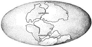
Pangaea is here beginning its division into Laurasia and Gondwanaland, with the Tethyan Ocean slowly opening up between the two giant supercontinents, from which all the present-day smaller continental bodies were born.
discontinuous and almost randomly scattered across the continents today, joined up when the continents were theoretically pushed together, and huddled around what looked like what once was the world's 300-million-year-old South Pole.
It all began to look very compelling, with more than enough evidence of later fossilized events to allow Wegener to follow the tracks that the chunks of continental crust must have taken across the surface of the globe to their present positions. Gondwanaland, for example, could be seen breaking up into the massive bodies that would in due course become Africa, Antarctica, South America, Australia, with the peninsulas of India and Arabia floating off into their own separate existences from within it: Wegener was able to plot how the fragments moved, when they moved, where they ended up at different times in the geological past.
Laurasia had exploded too, fragmenting into wandering lumps that had the vague appearance of North America, Greenland, Europe and that part of Asia that today lies north of the Himalayan Mountains. Wegener was able also to suggest the paths of their various intercontinental excursions, and nudge them into their present shapes and dispositions.
The more that this modest, tweedy weatherman thought and theorized, the more it seemed probable to him that the two early continents of Laurasia and Gondwanaland had themselves in fact been one. This single Ur-continent came to be called Pangaea (though Wegener, who was credited with its invention, never actually used the word: the very Nordic term Pangaa appears in a later edition of his book, though it is not at all clear that he coined this either. The first use of the word comes in a 1924 translation of Wegener's book, by a man named Skerl). Pangaea had then broken apart in some giant mitosis, the Tethyan Ocean had swept in between the superfragments that resulted - and then many tens of millions of years later these two smaller bodies had broken up as well, eventually giving us the world we know and recognize today.
‘One day a man visited me whose fine features and penetrating blue-grey eyes I was unable to forget,’ the great German geologist Hans Cloos later recalled of his first meeting with Wegener. ‘He spun out an extremely strange train of thought about the structure of the Earth and asked me whether I would be willing to help him with geological facts and concepts.’ Such was the beginning of Wegener's attempts to get his idea accepted. It was a battle he fought long, and ultimately in vain. The world was simply not ready to accept that its surface moved with such immense drama.
Hans Cloos, who was himself to become a grandee of fundamental geology, with papers on the physics of faulting and the deep-seated deformations of granites, was kindly and sympathetic - though never entirely convinced. Wegener's theory, he wrote, ‘placed an easily comprehensible, tremendously exciting structure of ideas upon a solid foundation. It released the continents from the Earth's core and transformed them into icebergs of gneiss on a sea of basalt. It let them float and drift, break apart and converge. Where they broke away, cracks, rifts, trenches remain; where they collided, ranges of folded mountains appear. It was tempting to believe it - but it was not a temptation to which Cloos, thus far inhabiting a comprehensively proofless world, was quite prepared to yield.
The rest of the academic community was implacably hostile, almost to a man. ‘Utter, damned rot!’ said the president of the American Philosophical Society. ‘If we are to believe this hypothesis we must forget everything we learned in the last seventy years and start all over again,’ remarked Thomas Chamberlin, a towering figure in American geology, on hearing Wegener speak in New York in 1923. ‘Anyone who valued his reputation for scientific sanity,’ said a British geologist, at the same time, when Wegener's ideas were being given wide airing, ‘would never dare support such a theory.’
Harold Jeffreys, a giant among early geophysicists, denounced Wegener with indignation and scorn: however powerful the forces that might be brought to bear beneath the earth's crust, none could be sufficiently strong to move it. And what of all the suggestive evidence of the Permo-Carboniferous Ice Age cluster, neatly arranged around Gondwanaland's South Pole - perhaps the strongest piece of evidence that Alfred Wegener had? Mere ‘geopoetry’, they said, the stuff of little more than idle fantasy.
And so Wegener was pushed out into the cold, like a querulous customer in a bar-room of rowdies. Not a single German university would give him the professorship that his otherwise impeccable pedigree deserved; it was left to the University of Graz, in Austria, to offer him only the chair in meteorology. He was obliged to stand away from the geology that was the business of others.
Alfred Wegener died young, quite convinced that he was right, but with the world beyond equally convinced that he was wrong. His ideas, it was almost universally agreed, were the results of bad science at best, wishful thinking at worst.
He died in his beloved Greenland, contentedly engaged with the problems of what the weather was doing above the earth, rather than worrying over the complex strangulations of what might have happened below. He had helped set up an observation camp 250 miles inland, high up on the ice-cap, to study yet again the Byzantine wonder of the polar climate. He was said by his companions at the time to be deeply happy, blissfully unworried by the firestorm he had ignited among the academic community back to the south.
It was shortly after his fiftieth birthday, on 1 November 1930, that he and his faithful Greenlander companion, Rasmus Villumsen, set off to return to the west coast. It was very cold - recorded temperatures of - 58 °F - and dark; the only blessing was that the howling gales were, at least when they left the ice-camp, at their backs.
But neither man was ever seen alive again. The following May an expedition was sent out, and found Wegener's body, fully dressed, lying on a reindeer skin in a sleeping bag. His blue eyes were still open, and he seemed, the expedition report noted, to be smiling. It appeared that he had died of a heart attack; his companion had seemingly pressed on for the sea, but perished in the attempt. His body was never found.
The men who found him erected a 20-foot iron cross above the nameless spot on the glacier where he died. Sometime in the fifties, when another dog-team passed by, the cross had vanished. The glacier ice had moved on and torn itself to pieces, taking Wegener's body with it.
It would be stretching a point to suggest that the ice moved in quite the way the earth did. Indeed, the mechanism for the earth's postulated crustal movement was one of the factors that Wegener did not understand, and could not fully imagine; his inability to do so was one reason why his sceptical foes were so active and effective. But in Greenland the ice moved, and yes, whether it was provable now or sometime in the future, the earth's crust surely moved too. One can almost hear Wegener, calm and pipe-smoking to the end, insisting to those around him who would not believe, and using the very words that Galileo Galilei had used to the Churchmen who had made him recant nearly three centuries before: ‘Eppur si muove.’ (‘You may force me to say what you wish; you may revile me for saying what I do. But it moves’.)
And as with Galileo, so with Alfred Wegener. Aside from the barest murmurs of dissent from groups of present-day fundamentalists, creation scientists and Flat Earthers, the entire scientific world now happily acknowledges that Wegener, whom all once thought a crank, was in essence, and in fact, quite right.
Moreover, in the particular context of this story, it turns out that the very processes that Wegener first and so bravely suggested do indeed happen to underlie, both literally and figuratively, the making and unmaking of all volcanoes - the formidably spectacular eruption of Krakatoa among them.
3. Divination
Yet it was not anywhere near a volcano - and certainly not in the steamy heat of Java or Sumatra - where Wegener's theories first came to be confirmed properly. In the 1960s hard scientific evidence decisively proving the occurrence of continental drift flooded in from a great many sources - some of the most compelling being found fully 10,000 miles and two hemispheres away from Krakatoa, and eighty years after the catastrophe that happened there. Wegener would have savoured this particular irony of geography, since it was early exploration work in the high Arctic snowfields of east Greenland where some of his ideas were first fully tested and shown to be sound.
As it happened (and by a series of strange coincidences that I was not to appreciate fully until the day many years later when I stood watching the sound and light show from Anak Krakatoa), I played a part - a very lowly part but an unforgettable one - in one of the Greenland expeditions where some of those first confirmations of continental drift were gathered in. I was lucky: I happened to be in just the right place at what science has now shown to be just the right time.
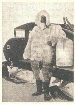
It was the summer of 1965, and I was a 21-year-old geology student at Oxford. And though I did not attach any special significance to it then, much of the unravelling of the most profound enigma of the world's volcanoes - why do some parts of the world erupt, while the rest do not? - started at the very same moment that I happened to win a place on a small expedition to a wild and unknown part of the east Greenland coast. While I was packing my steel crampons, shark-skinned skis and moleskin salopettes for the journey north, I had not the vaguest thought in my head that this trip might have anything to do with a tropical mountain of which I knew very little, and that lay half a world away.
From the moment I first spotted the Greenland announcement, thumbtacked on to a department noticeboard among offers of second-hand mineralogy textbooks and a former student's barely used Estwing hammer and Brunton compass, I was entranced by the thought of a summer in the cold of the far, far North. I positively yearned to go.
I had long felt a strange compulsion towards high latitudes. As a child I had been raised, quite conventionally for a Briton of my generation, on the heroic imperial stories of Scott and Shackleton, and, less conventionally, on the tall tales of even more heroic foreign figures like Fridtjof Nansen and Peter Freuchen. Much later, and thanks to the peculiar Arctic interests of my Everest-climbing Oxford professor, a tiny but physically and intellectually powerful man named Lawrence Wager, two of the most renowned of Greenland wanderers, Knud Rasmussen and Gino Watkins, became the greatest of my heroes too. Suddenly the chance of being able to take off to spend some time in their Arctic, in the wastes where they had made their names, seemed to me the most noble and romantic of ideas.
Since I had no obvious qualifications for making the team, I decided to teach myself a vaguely appropriate skill that might make me of some potential use. Morse code seemed as good a choice as any, and so I spent a fortnight learning it, and became in short order reasonably competent and fast. I then put the word around Oxford that I might in consequence have something valuable to offer. The ploy evidently worked. Shortly before the expedition was due to set off, and just as I had hoped and schemed, the leader called me for an interview, and, on hearing of my self-professed ability to tell a dot from a dash (he had me tap out the highly rhythmic code for the word ‘essences’ on his desktop), he signed me up. I was to go along as sled-hauler, because I was reasonably fit and strong; and I was required to add to my duties that of radio operator. Only out on the ice-cap did I discover that the team's radio was in fact set up for voice transmissions alone: there was no Morse key, nothing that would allow me to show off.
What happened that glorious high Arctic summer still remains paramount as the purest of adventures, the dream of every schoolboy everywhere. Despite my having subsequently lived a life of fairly unremitting world-wandering, that two-month expedition to the Blosseville Coast, south of the great high Arctic fjord-system (the world's biggest) known as Scoresby Sund, has never once been matched. The memories of those fifty days stay with me yet.
It started with embarkation in Copenhagen, the piles of expedition boxes among the coils of rope and crates of fish, the cold smell of the northern sea and the sweet-sharp aroma of Stockholm tar. It got properly under way a few days later, at the moment when, from the ice-breaker's chilly bridge-wing, we first picked out the luminous glow of the isblink on the north horizon of the Denmark Strait, and our little red ship began bucking and cracking her hull through the thick and wind-scoured pack-ice.
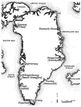
Greenland. The vast fjord-system of Scoresby Sund begins halfway up the east coast.
From then on, as we went higher and higher above the Arctic Circle, every subsequent moment, every experience, became vivid, intense, unforgettable. We landed on a remote beach on the iron-bound coast of the immense, mysterious island. We climbed, in brilliant sunshine, the ice-wall and then the crevassed length of a fast-moving, mile-wide glacier. We spent weeks camping high on the ice-cap. We rappelled down sheer walls of black basalt. We skied for scores of miles over snow where none had ever been before.
We learned to speak the Danish-Inuit linguistic blend called Greenlandic, in which the country is called Kalaallit Nunaat, ‘our land’, in which a snowflake is qanik, snow flurries nittaalaq nalliuttiqattaartuq, and a good forty-seven other words besides speak of snow or ice and their many varieties. We grew beards, we grew strong, we became bronzed by the perpetual midnight sun. And when the season was ending, and the dark and the cold crept in, so we would thaw our boots out each morning over the Primus stove and watch as our hot washing-water, when we tossed it into the air, fell back as a mist of perfect snowflakes.
There were problems, naturally. We ran out of supplies (except for low-temperature margarine, of which we had a good quarter of a ton), and so I - no great shot at the best of times, but the caretaker of the expedition's only rifle - had to shoot a polar bear for food. It was an aged bear, not at all tasty, and its limbs were riddled with Planaria, flatworm parasites that we had to tease from between its thigh muscles. The following day, entirely by chance, I followed the shooting of the bear by bringing down a goose, in flight, with another single shot. From today's perspective, all horribly incorrect things to do - except that we were keenly hungry, and there was nothing else to eat.
We then found ourselves socked in by bad weather, were delayed by two weeks, and our Danish ice-breaker had perforce to leave for Copenhagen without us. We had to risk walking for an endless day, sixty-pound boxes of precious rock samples on our backs, over a crazed sea-carpet of thin and fast-shifting ice-floes in order to reach an Eskimo settlement, and relative safety. We still needed food: we hunted musk-ox with the local men, and then dined with them on young seals, the seals' bellies opened up and filled with roasted sea-birds (to which we added from our near-depleted stores, as the most unfamiliar of condiments, bay leaves).
And we barely got home. The season was changing; the sun was setting earlier and earlier each afternoon; storms were blowing in from the north. The brave Icelandic pilot who came to collect us in a blizzard, in the near-dark, was killed the very next day, flying his Cessna into a cliff in that mythically ghastly part of north Iceland called the Claw. When we heard the news, we had been celebrating, eating cream cakes in the Savoy in London: we slunk away to our various homes in an awful, sombre silence.
But however memorable Greenland was as an experience, it was as science that our little expedition had its greatest value.
Ours was not the only expedition of its kind. At around the same time Oxford was sending people to Spitzbergen, Arctic Canada, Finnmark and elsewhere in the Arctic, with much the same scientific aims; and other universities and institutions did likewise. There was a great curiosity, particularly among geologists, about what could be discovered in what they called The Great White.
What we found out - or, more precisely, what was found out by others in distant laboratories once they had examined the rock samples we brought back - helped to prove a theory that, then still young enough to need the sturdiness of proof, turns out today in its maturity and certainty to have the most profound relevance to Krakatoa and to the key story of this book.
The frigid black-and-white coast of east Greenland may be a very long way from the lushly tropical green islands west of Java. But the two places in fact have a good deal in common, geologically. They are not formed from sandstone, or from shale, or from soft layers of fossil-filled chalk. They owe their origins instead to fire and brimstone. Both Greenland and Java are volcanic places, seared and branded into place by the earth's most elemental processes. And more than that: each was made, and stands where it does on the planet's surface, thanks to the workings of a once mysterious, much derided mechanism that was initially uncovered (or, at least, more than partly confirmed) by those who examined the collections, results and observations that our trifling little expedition and others like it brought back home.
Our collecting boxes (and many that we were obliged by the foul weather to leave behind and collect the following summer season) were filled with scores upon scores of carefully drilled and numbered samples of the country-rock of east Greenland. And that means volcanic rock. At the latitude where we had been on the island's east coast, Greenland is more or less entirely underlain by basalt - a dark-grey, fine-grained variety of volcanic rock that was laid down in layer upon layer during Tertiary times, thirty million years ago.
Basalt is outwardly an unremarkable rock, generally scenically unpromising (except in its columnar variety, when it forms beguiling spectacles like the Giant's Causeway in County Antrim, or Fingal's Cave on Staffa). On close examination it is not at all pretty: it does not hold a candle to decorative igneous rocks like granite or gabbro or varieties of the more exotic porphyries; nor does it often compete as building stone with Jurassic limestones or Italian marble. But for the six of us trudging across the snows that summer, charged with this very particular task, the basalts did have one uniquely interesting feature, one that may not have been readily apparent to the casual glance, but that was crucial for what was then a fledgling programme of geophysical detective work.
Cooling basalts, it turns out, contain small crystals of iron-oxide compounds - principally of the cubic spinel mineral magnetite, Fe3O4 - that are highly magnetic. During the molten, plastic phase of their cooling process these crystals tend to act as miniature compasses, swinging hither and yon in the still viscous mix, in an elegant harmony that is extremely susceptible to the lines of magnetic force that radiate between the earth's North and South Poles.
Once the cooling has concluded, and the magma has passed what is known as the Curie point and become solid (technically frozen, though the word used here has nothing to do with the freezing of water and snow, which takes place at a much lower temperature), the alignment of the swarms of magnetite compasses becomes fixed, and is set for all time. And each, crucially, is then aligned to where the North and South Poles were at the time the rocks froze - in this east Greenland case, thirty million years ago. The compasses are thus powerfulforensic tools: they tell us where the poles were in relation to the rocks, or the rocks in relation to the poles, a long, long while ago.
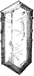
A crystal of magnetite, usually aligned with the poles along its long axis.
Our task - which had been set by a small number of curious laboratories around the world, and whose professors some months before had persuaded a variety of grant-bestowing bodies to give us sufficient money to charter the icebreaker and buy our Nansen sleds and our pemmican and hard tack and then to set off - was to collect hundreds of samples of these basalts. If and when we got them home, they would be sent off to the researchers, who would measure the strength and the direction of the relict magnetism of the iron-oxide particles contained within them. In truth the strength of the age-old magnetism only claimed their most cursory interest. It was the direction of magnetism that beguiled them most - and in connection with that we were asked to note very carefully indeed, while taking the samples, the way they were aligned, relative to the North and South Poles of today.
So we spent hours - day and night, bathed in the Arctic summer's continual sunshine - painstakingly drilling basalt samples out of the sheer walls of the local nunataks. We used a portable power-drill (with a diamond-studded bit that needed to be cooled by dousing it with bucketfuls of snow) and a very accurate sun-compass* to make sure we always knew where each sample lay relative to the present-day poles. The selected cores, eight inches long, two inches in diameter, were then indelibly marked with their geological horizon (how high up each had been found among the other layers of rock) and their sun-compass orientation, wrapped in plastic and set aside in specially made boxes of strong and waterproof fibreboard.
The science that required the presence of all those basalt cores was elegantly simple and, by the standards of the present day, somewhat mundane. The interested scientists all wanted to work on the samples to satisfy a suspicion that had been growing during the early sixties. This burgeoning belief was rooted in an unsay-able, almost (in some quarters) a heretical view of the making of the modern world, and held that the magnetic alignments of crystals in rocks laid down in the past might, just might, be substantially different from the alignments of the rocks themselves today. This was something that, if it could be demonstrated, would spawn a profound revolution in contemporary geophysical knowledge and thinking. If it were to be proved, then the unsay-able would suddenly become something to preach, and the heresy would, overnight, become dogma.
And that is just what happened. The rocks we brought back did eventually (though many months later) prove essentially and exactly what everyone wanted them to prove. A comparison of the directions of the spinel compasses (the science of studying such phenomena had a century before been given the hybrid Greek-Latin name of palaeomagnetism) confirmed what a very large number of scientists suspected. There was a very considerable difference between the direction in which the Tertiary magnets were pointing and the position of the poles today. All of the millions of magnets were lined up not towards the present poles at all, but towards a point some fifteen degrees to the east of them. It was a simple realization, but it had a stunning effect.
This meant one of two things: that either the poles had moved in relation to the rocks or the rocks had shifted in relation to the poles. The first was initially the more tempting possibility, since it seemed quite simple for the North Pole, which was after all an invisible and rather mysterious entity, to have somehow shifted itself around by fifteen degrees. But the scientists who were doing the work on our rocks had an advantage, in that they knew this could not be the case. They were already performing palaeomagnetic studies on the other Arctic rocks of the same age, on samples from Spitsbergen and the Faeroes and Norway. What they found was that the computed polar positions suggested by the spinels in these rocks varied wildly - so much so that it looked not like the poles were wandering, but rather like there were scores of North Poles, all existing at the same time.
So if there was no polar wandering, then the alternative could be the only explanation. It was an explanation that proved a Eureka moment, a truly life-changing epiphany for many of those researchers back in the sixties. It was the realization from the record of the rocks that the basalts of east Greenland had moved. Somehow the basalts of east Greenland had drifted westward, through fifteen longitude degrees or so, in the thirty million years since they had been extruded from the earth.
In other words, the long-imagined (but until this moment, generally discounted) phenomenon of continental drift had - and now, moreover, provably and incontrovertibly - occurred. During Tertiary times the sea-floor beneath the Atlantic Ocean had clearly and demonstrably spread open. Now, from the Greenland basalts, there was powerful evidence to suggest that the theories of continental movement - with the world beginning as one supercontinent, Pangaea, which had then broken up and spread itself over the global surface - which Alfred Wegener had advanced so obsessively and which had been so widely dismissed by the scientific establishment during most of the half century beforehand, had at last been more or less decisively confirmed.
Later in the 1960s, and with a growing amassment of evidence like that from east Greenland now safely in the bag, a great scientific sea-change was in the offing. It first came about unexpectedly. It first came about by accident, and in a much more appropriate piece of geography, off the coast of Java, almost within sight of the island of Krakatoa. And it first came about, as sea-changes are wont to do, at sea.
There were two initial discoveries. One advanced the evidence of sea-floor spreading and the consequent drift of continents from the merely circumstantial into the happily incontrovertible. The other provided sceptics with something that Wegener had never managed to produce: the model for a mechanism that explained how spreading and drift might work.
This first came to light after a series of unrelated experiments conducted off the south coast of Java - quite properly for the present story, and particularly so in that the scientist who performed the work was a Dutchman, from Delft Technical University, by the name of Felix Vening Meinesz.
His initial intellectual interest was quite unrelated to continental drift: Vening Meinesz was solely concerned with the very accurate measurement, at various places on the globe, of the earth's gravity. He was especially concerned with the measurement of gravity in the mysterious world below the very deep oceans. Since gravity is an acceleration, it is extremely difficult to measure from something that is itself moving - like, say, a ship. So Vening Meinesz had to try out a series of home-made and very specialized measuring devices.
Although the wholesale acceptance of continental drift was not to come about for fully forty years after Wegener's death, Vening Meinesz performed his early work while the unsung pioneer was still alive, between 1923 and 1927. He had taken a crude gravimeter, consisting of a pair of pendulums swinging in opposite directions, and mounted it on gimbals inside the most stable sea-borne vessel he could imagine, a submarine. He then had the Dutch Navy, using submarines with the somewhat unimaginative names of Her Majesty K II and Her Majesty K XIII,* perform a series of shallow dives off Java - and found to his astonishment that about 190 miles off the southern coasts of both Java and Sumatra, there was a dramatic lowering in the strength of the local gravitational field.
This enormous gravity anomaly coincided precisely with the existence of a tremendously deep and long gash in the sea-floor known as the Java Trench. To appreciate the depth of the Trench, one can imagine someone moving eastwards (driving some seabed crawling machine, if that is not straining credulity too much) two miles beneath the surface of the sea, somewhere off Christmas Island. Without warning the seabed starts to slope downwards at a gradient of 10 per cent or more. It keeps on going down, down, down-until, at the dark and ice-cold bottom of the Trench towards which the slope is heading, the sea is nearly five miles, or 24,440 feet, deep. Then, even more abruptly, the bed begins to climb back up, dipping briefly down, once, and then rising one final time clear up to the continental shelf, the shallows, the fringing reefs and finally the beaches of south Java itself. Within 200 miles of the shore are some of the deepest parts of the world ocean - and directly above them, Vening Meinesz discovered, some of the lowest and weakest ravit accelerations to be found anwhere.
The Dutchman was promptly invited to the United States by a young Princeton scientist named Harry Hess; and, together with two other young men who were to go on to become rising stars in the new field, Maurice Ewing and Teddy (later to be Sir Edward) Bullard, they took off in a boat called the Barracuda to see if the Javan anomalies could be found above the submarine trenches known to exist in the Caribbean. They did, spectacularly so. The four excitedly discussed why this might be - with Harry Hess and Vening Meinesz openly speculating that they were caused by some mysterious force dragging the rocks of the seabed downwards and (as it were) dragging the gravity down with them. Hess wrote a seminal paper in 1939:
Recently an important new concept concerning the origins of the negative strip of gravity anomalies… has been set forward… It is based on model experiments in which… by means of horizontal rotating cylinders, convection currents were set up in a fluid layer beneath the ‘crust’ and a convection cell was formed. A down-buckle in the crust… was developed where two opposing currents meet and plunge downwards. So long as the currents are in operation, the down-buckle is maintained… the currents would have velocities in nature of one to ten centimetres a year…
Perhaps, at last, we had a theoretical mechanism. Perhaps there were currents below the solid surface of the planet, currents that dragged the continents along on top of them and that then plunged downwards, dragging the continents down with them. Continents might thus be moving towards or away from one another at between half an inch and four inches every year - a rate that, miraculously, was entirely consonant (once someone hurriedly did the arithmetic) with what Wegener had proposed for the break-up of Gondwanaland more than twenty years before. But this was 1939, and the world was being enveloped in a
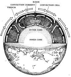
The process of convection inside the earth's mantle, the driving mechanism behind continental drift and plate movement.
man-made turbulence of a very different kind: Harry Hess and his bold theory would have to wait until the war was over.
But when it was over, a wholly new and unexpected piece of evidence for crustal movement came to light - also at sea, but this time not off Java, but off the north-western United States. And while the first ground-breaking pre-war study had to do with anomalies in the earth's gravitational field, this next series of experiments had to do with a study of the earth's magnetism. More especially, they were concerned with what was known as the remanent magnetism that might be held in the rocks of the sea-floor, the old magnetic signatures that we later studied in east Greenland.
The pioneering work on remanent magnetism had been accomplished largely by an ebullient red-headed Mancunian named Keith Runcorn. He was a lateral-thinking geophysicist who wondered out loud if perhaps the magnetic field of the earth somehow varied over time - if it had perhaps varied in its strength or its direction. And if it had varied, then perhaps a record of those variations would be discoverable by examining the remanent magnetism of rocks laid down during the time that was being investigated.*
In the early 1950s Runcorn and his colleagues, and associates, using a range of devices (including a sphere made of thirty-seven pounds of pure gold, borrowed from a very sceptical British Royal Mint), studied this fossil magnetism in a variety of rocks of a variety of ages across Britain. The conclusion to which they came was published in a paper in 1954. The evidence showed that there were indeed significant variations in the magnetism held in rocks of different geological eras, and this could really be accounted for by only one of two happenings: either the magnetic poles were wandering about relative to the earth's landmasses, or the earth's landmasses were wandering about relative to the poles. The latter was continental drift - and to Keith Runcorn it looked a most temptingly plausible explanation.
Further compelling evidence to support this notion was soon to come in. If the rocks on other continents showed the same remanent magnetic evidence for a wandering of the poles, then it was likely that yes, the poles themselves had moved. On the other hand, if the results from continents far away from one another were different, then it would suggest that it was not the poles that had moved but the continents. And in 1956 that evidence came in - showing, to the delight of people like Keith Runcorn and Harry Hess, widely different degrees of magnetic variation. The differences could be accounted for only by the continents having drifted apart from one another. The noose was closing. Wegener's theories were being resurrected, and fast.
The clincher came quite accidentally, in work that began in August 1955, in the cold seas between America's most westerly point, Cape Mendocino in California, and the southern tip of Canada's Queen Charlotte Islands. An English geophysicist named Ron Mason, on sabbatical at Caltech, was vaguely aware of highly classified US Government research into underwater magnetism - classified, it was said, because the US Navy was looking at deep-sea hiding places for its long-range submarines.
Over coffee one morning he asked whether it might be possible for him to join Project Magnet, as it was called and, without interfering with the government work, to tow a magnetometer behind the project's ship and make his own maps of any magnetic anomalies he might find down on the sea-floor. The project director agreed: and that summer Mason arranged for a long, floating, fish-like object - known formally, in the kind of language heard in science fiction, as an ASQ-3A fluxgate magnetometer* - to be towed behind the US Coast Guard's ship Pioneer as it searched for seemingly more important things on behalf of the Pentagon.
Ron Mason's instruments up in the Pioneer's operations room, hooked by wire to the magnetometer that was trailing behind and below the ship, recorded variations in the strength and direction of the magnetism of the seabed rocks below. The recording paper unrolling from its drum (which in due course was to be superimposed on a topographical map of the sea-floor and the Pacific coastline) indicated the data by way of an intricate trace of lines - with some of the lines showing rocks that had certain properties, and others indicating rocks that had properties that were precisely the opposite.
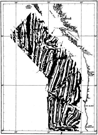
The magnetic ‘zebra stripes’ discovered on the seabed of the north-western Pacific in 1955, which were finally to confirm the idea of sea-floor spreading.
As the hundreds of miles of ink traces began to plot out on the screens, Mason could hardly believe what he was seeing. At first the marks on the ever rolling drum seemed meaningless, no more than a random mess of indecipherable hieroglyphs. Within a few
hours, however, the traces quite inexplicably began to display an absolutely regular, absolutely consistent pattern. As the ship cut steadily through the water, and as the floating ASQ-3A behind recorded the magnetic fields in the rocks hundreds of fathoms below, so the traces began to arrange themselves in an unmistakable pattern of parallel and linear stripes, just like those found on the skin of a zebra or tiger.
The stripes became more and more obvious as, month by month, the little ship worked itself steadily along its recording route. The vessel would scuttle back and forth on its preordained track, the midshipman keeping it at a steady five knots for hour after hour, as it traced and retraced its passage along the specific sector of sea-floor that Ron Mason had decided to measure. And as it did so, so the zebra-stripe pattern from the rocks below steadily built itself up - with the recording paper eventually being covered with long black-and-white patches that alternated from black to white to black and back to white again in an ever more uncannily regular manner.
All of the stripes, moreover, were not simply regular. After just a few passes of the Pioneer, their arrangement could be seen: they pointed not merely in parallel but essentially only to the north and to the south. Or, to be more accurate, they pointed along the long axis of the ocean in which they were found.
The ship might go east-west, it might go diagonally; it might reverse its voyage - but no matter. Pass after pass after pass, the magnetism in the rocks below was recorded as a series of stripes arranged in long north-south trending patterns that made the plot of the seabed look like an acrylic bed-sheet from Frederick's of Hollywood, or a herd of standing zebras or tigers, rather more exotic than it deserved to be.
And then in a flash everyone realized what it was. The stripes on the paper were noting anomalies that were a record of the reversals that had occurred from time to time in the polarity of the earth's magnetic field.
This was a curious reality that had been dimly recognized by a Frenchman named Jean Brunhes in the early part of the century, then confirmed (by a Japanese geophysicist named Motonari Matuyama) in the 1920s. He showed that there had been a field reversal during the late Pleistocene, 10,000 years ago. Thirty years later his work had been fully confirmed: basalt layers in Iceland showed a series of back-and-forth field reversals in their remanent magnetism. From then on there was no doubt about it.
The work in Iceland and elsewhere showed field reversals to be a standard (if stubbornly inexplicable) feature of the earth's magnetic field, just as can happen in any man-made self-exciting dynamo. Over the last 76 million years, the palaeomagneticists soon reckoned, there had been no fewer than 76 such reversals - and they had continued to a measurable degree right back to the early Jurassic, 150 million years ago (except for a long period between 85 and 110 million years ago when, equally inexplicably, there were no reversals at all, during what has since come to be known as the Cretaceous Quiet Zone).
And now here, at last, was evidence in black and white of reversals in the rocks' magnetic field, and moreover reversals that, when plotted on to a map, seemed to occur along regular lines, following a pattern that was imprinted indelibly on the seabed of the north-eastern Pacific. And, as more and more data was recorded and analysed, something even more astonishing was noticed: that the peculiar intricacies of the stripe pattern on one side of the ocean were almost identical to those that could be seen in the stripe patterns on the other, and that there was a point, or axis, in mid ocean, on which this symmetry seemed to hinge. In an instant the explanation for that became clear too.
The north-south trend of the magnetic stripes suggested that the rocks below were moving outwards, were on each side flowing away from this central point, just like rainwater hitting the ridge-pole of a roof, with some water then going down one side of the roof, some the other.
And the conclusion to be drawn from this turned out to be the single missing part of the mechanism for continental drift, the one that Alfred Wegener had never been able to imagine. The mid-oceanic north-south axis was a place where - presumably, logically, but suddenly somehow astonishingly - entire tracts of brand new seabed were being created. The mid-ocean axis was a ridge of making, where the world was welling up from inside itself and spilling out on to the floor, to be carried out and away, thus making ever more room for the making of more.
And as this brand spanking new submarine real estate was being slowly and steadily made over millions of years, and as it spread off away from the deep-sea ridge-pole both to the east and to the west, so the remanent magnetism of its rocks, with the record of the earth's polarity reversing itself every few tens of thousands of years, remained locked there on the sea-floor for all to see. By seeing this, by understanding what it was, scientists were able, at long last, to claim they had evidence of sea-floor spreading that was incontrovertible. Once radiochemical dating techniques had been perfected, then the timing of the spreading, of the making of new seabed, as well as the dating of the continental drift could all be fully established too.
Now that there was a mechanism and a date, the rest suddenly became almost too obvious. The conclusions began rushing in, filling the intellectual void that had so plagued the science for all the decades since Wegener had died forty years before.
In 1962, armed with the new evidence from the Pioneer and all the other armadas that dragged schools offish-shaped magnetometers behind them,* Harry Hess decided he would revisit the nagging question that the war had so rudely interrupted. There was now solid new evidence to underpin his notion that convection currents were at work under the earth's crust, and that the continents were indeed being moved about upon it, like gigantic rafts, colliding and bouncing and plunging down back into the earth's molten heart, in a ceaseless supra-terrestrial dance. ‘One may quibble over the details,’ he wrote in a paper that year, which is now a classic,* ‘but the general picture on palaeomagnetism is sufficiently compelling that it is more reasonable to accept than disregard it.’ Continental drift was most assuredly taking place. There could be no doubt - and, indeed, since the publication of Harry Hess's paper, there never has been.
By curious chance, I came to know, if only slightly, both Harry Hess and Keith Runcorn. The encounter with Hess was to provide the more embarrassing memory, at which I blush to this day.
It was the early spring of 1966, and I was approaching twenty-two. I had lately - for reasons of Buggins's turn, rather than any innate talent - been elected president of the Oxford University Geological Society. In that capacity, and because I had often visited America - and Princeton University as well, as it happened - I had managed to persuade Professor Hess to speak to the final, celebratory Society meeting of that Hilary Term. Hess was by then a famous figure, and his acceptance of an invitation written by a mere undergraduate was a signal honour for all. Senior academics from most of Oxford's science departments were eagerly gathering to hear the great man speak.
It is a tradition of the Society that the event's protagonists - including the guest - wear black tie. Accompanied by my lieutenants, I met Hess (he was clothed as requested, though he called it his ‘tux’ and it looked suitably moth-eaten and academic) at Oxford railway station. We had decided to give him (and ourselves - we were spending official OUGS funds) a good feed at a well-known riverside inn out in the country, perhaps ten miles from town. So the five of us - Society secretary, treasurer, vice-president, Hess and me - drove off in my 1935 Morris 8, a venerable car much prized by my friends but, as it turned out, of lamentably timed unreliability.
We dined early and very well, beside an immense inglenook-fire, in a building composed of ancient thatch and mid-Jurassic corbels, on soup and lamb and a '59 Aloxe-Corton. Our date with the assembled worthies of the university was at eight thirty, in the Museum. We left at ten minutes to eight - ample time to get to the venue. Harry Hess had enjoyed the Corton, and we had opened, as I recall, three bottles. He was a happy man.
The car, however, was less so. It broke down in some flat and nameless swamp, five miles equidistant from both inn and Oxford. It was foggy, cold and dark. We had no telephone, and no way of finding one. Our only option was to walk, taking a path that our treasurer claimed to recognize and that he laughably described as a short-cut. Well-shone black patent shoes are less than suitable for the Oxfordshire mud. We found a pub, made a telephone call - but the person who answered hadn't heard about any meeting or any museum. Hess had a couple of whiskies.
We arrived back in Oxford at ten o'clock - muddy, wet, cold and, in the case of Harry Hess, agreeably and pleasurably drunk. Our audience had remained, not knowing what else to do. The speech was a disaster. Someone tripped over, and much of what was said was incoherent. Maps fell down. The projector fused. The front row glared at us, deeming us responsible for the supposed slur on this monarch of high academia.
I was not asked to convene any further meetings of the Geological Society; but Harry Hess wrote later to say he could not recall a more amusing or satisfying evening in recent years, and hoped that we would remain in contact - which we did, until he died three years later.
I had known Keith Runcorn well during my time as a reporter in Newcastle-upon-Tyne, where he was professor of geophysics. He had taken me under his wing, seeing me as a local reporter interested in science who might help him publicize his research on deep-ocean tides. He had an arrangement with Cable & Wireless to make use of one of their disused trans-Pacific telegraph cables, and had set up monitoring equipment on Fanning Island, in what is now the Republic of Kiribati, to measure the tiny electrical impulses generated in the cable by the deep-water tidal movements in mid ocean. For readers in the grim and grisly winters of Tyneside, newspaper stories about the blue waters and eternal sunny skies of a South Pacific atoll made a welcome change; I wrote about him often, liked him enormously, and only wished that my paper had the budget to let me go out, as he had often suggested, to spend a season on Fanning, measuring the currents, soaking up the Polynesian Way.
Once I left the north-east of England, Keith Runcorn and I lost touch - one might rightly say that we drifted apart. From time to time I would see his name on various celebratory papers, or on programmes for conferences called to note this anniversary or that, and all to do with the theories of continental drift of which, along with Hess and a small army of others, he was now world-renowned as an architect.
And then, in December 1995, I read that he had been found, brutally murdered, in a hotel room in San Diego. He had been on his way to the annual meeting, in San Francisco, of the American Geophysical Union. He was to give a paper about his new interest, the magnetic fields that were then being measured on the surface of the moon.
4. Definition
It turned out to be but a short step from a wholesale acceptance of the mechanics of continental drift to the creation of the new theory that would be christened plate tectonics - that set of abiding planetary principles that today is generally acknowledged to be the first properly global theory to have been adduced and accepted in the history of earth science.
The crucial first mention of the theory came on 24 July 1965, in the British journal Nature, under the authorship of the genial Canadian who is now most generally accepted as the ‘father’ of plate tectonics. Many hundreds of scientists had already spent thousands of man-years working away with their gravimeters and magnetometers, their polarizing microscopes and their hammers, to create a vague and pointillist image of the emerging theory. But it was not fully recognized until that summer's morning in 1965, when the thick, red-covered and always in those days infuriatingly tightly rolled magazine thudded on to desks in geological laboratories across the world. And then, though scores had been involved, no scores seemed to need settling: there was no contest for this particular moment of glory. It was the bluff, genial, approachable and down-to-earth University of Toronto professor J. Tuzo Wilson who, by opening his four-page essay with the following declarative paragraph, in essence created the new science:
Many geologists have maintained that movements of the Earth's crust are concentrated in mobile belts, which may take the form of mountains, mid-ocean ridges or major faults… This article suggests that these features are not isolated, that few come to dead ends, but that they are connected into a continuous network of mobile belts about the Earth which divide the surface into several large rigid plates.
His realization was essentially two-fold: the one discovery announced in this seminal 1965 Nature paper; the other, inextricably linked to the first and made two years beforehand, when the reacceptance of continental drift was well under way, but in need of as much hard evidence in support as could be found.
The first discovery came when J. Tuzo Wilson looked at the Hawaiian Islands. After thinking about what he saw, he came up with a piece of evidence that added mightily to all the news about tiger-striped remanent magnetics and basalt conveyor-belts on the bed of the ocean. In the tradition of good science - close observation followed by prescient deduction, with in this case the addition of the basilisk glare of his own geophysical insight - he saw something, something that the ancient Hawaiians themselves had suspected for centuries.
The Hawaiian Island chain stretches for more than 2,500 miles, across thirty degrees of Pacific longitude. Most of the islands one would not think of as Hawaiian. Nihoa, Necker, Tern, Disappearing, Laysan, Lisianski, Kittery and Seal Islands, for example, are almost unknown: only Midway and Ocean Islands, at the north-western end of the chain, are household names, and those mainly because of wars and naval battles. What is currently (but technically wrongly) thought of as the Hawaiian Islands is the 400-mile line of just nine bodies of rock and palm reaching from the outermost pinnacle of Kaula, via the north-westernmost (and still privately owned) island of Niihau, to that great chunk of basalt at the south-east called Hawaii, which is known by most non-Polynesian visitors as the Big Island.
Hawaiian legend has long acknowledged what casual visitors may notice too: that the dusty, half-dead island of Niihau looks much wearier and older than the feisty, bubbling and fiery island of Hawaii. The dank black Waialeale swamp at the summit of Kauai - the wettest place on earth, the locals say - looks prehistoric; the fresh crags of Diamond Head on Oahu (the ‘diamonds’ being glittery and new-looking olivine crystals) look young.
To the ancient Polynesians, who closely examined the islands' soil erosion and vegetation, the difference in age was also self-evident. They incorporated the difference in age into their stories. Pele, the goddess of volcanoes, once lived in Kauai. But then she was attacked by her older sister Namakaokahai, the goddess of the sea. And so she fled, south-east, to Oahu. Namakaokahai attacked again, and Pele moved south-east once more, to Maui. And then a third time, whereupon Pele moved yet again, this time to the Halemaumau Crater of Kilauea, on the summit of Hawaii itself. She had moved 300 miles south-eastwards, hopping from island to island, as one volcano after another exploded and died behind her.
Like many legends, this old yarn has its basis in fact. The sea attacks volcanoes - the waters and the waves erode the fresh-laid rocks. And this is why Pele herself moved, shifting always to the younger and newer volcanoes, and relentlessly away from the older and worn-out islands of the north-west, and down towards their more recently created and unspoiled cousins in the south-east.
It was in 1963, in the cold of faraway Toronto, that J. Tuzo Wilson first looked at these stories, examined the geological maps, peered at the records of the various eruptions and lava flows on the Hawaiian main chain, and came up with an idea. Volcanoes had existed in this area of the world for what seemed a very long period of time. So it seemed likely that, for some reason, there was at this particular point in the earth's mantle a deep and stationary hot spot (geologists have since elided the phrase to form today's hotspot).
The heat from this fiercely hot zone partly melted the rocks of the upper mantle lying above it. The magma created by this melting was lighter than the surrounding solid rock; it burst through the remainder of the mantle into and through the crust; and then it erupted through the ocean floor to produce either a sea-mount that would remain always below the surface, or an undersea volcano that would grow until it breached the surface of the sea and emerged as an island.
That part seemed simple and logical. But what Wilson then deduced, both from the Polynesian legends and from his own observations, was that while the hotspot remained static, the upper mantle and crust above had moved, carrying one island at a time away from the hotspot and abruptly stopping the volcanism there. After a while, magma erupted again at a new site that lay in the wake, as it were, of the first moving island, and another fresh island was made altogether. It was rather like moving a baking tray full of batter slowly away from a single intense gas burner, creating a line of ripples and partially cooked batter - the batter cooked at one end of the tray, uncooked at the other, with all the stages in between.
Here in the Pacific, on a grand scale, was a 400-mile-long trail of volcanoes - in various stages of cooking. The older rocks were in this case at the north-western end of the trail, the newer rocks at the south-eastern. If the radiometric dating confirmed this, then it could be incontrovertibly proven that the mantle and crust along the Hawaiian chain was itself moving north-westwards over a hotspot that was now and long had been sited directly under where the Big Island is today.
And the dating of the rocks proved it, precisely. The Kauai basalts were shown to be 5.5 million years old; those on Hawaii itself were on average less than 0.7 million years old; and in the craters where Pele is said now to be lurking, they are still being created, millions of tons of hotspot-induced basaltic melt baked afresh every day.
The dating clinched the idea. Wilson was shown to be exactly right. Science could now add to the evidence of the tiger-stripe magnetic anomalies off Seattle this second indication of the undersea geological conveyor-belt. The magnetic evidence had been found below the surface; this from Hawaii was by contrast all on the surface. Together they presented science with a sort of gigantic rock-hewn tape-recorder that showed not only the mid-Pacific movement that had been taking place over the last five million years but also the expansion of the sea-floor, with the continents on each side of it, undeniably and indisputably, drifting.
The second realization - a true Eureka! moment of epiphany - came after Wilson starting experimenting not with rocks and magnetic traces or radioactive rubidium, but with paper and a set of scissors. The title of his famous Nature paper, ‘A New Class of Faults and Their Bearing on Continental Drift’, suggests why he was indulging himself so.
John Dewey, who went on from Cambridge to become professor of geology at Oxford, remembers the moment. It was
... one early autumn morning in 1964, I was sitting in my room in the Sedgwick Museum in Cambridge… when Toronto's Tuzo Wilson, on sabbatical leave, sauntered in clearly bursting to tell anyone who would listen about his new ideas. He had discovered that I was the new lecturer in structural geology and said: ‘Dewey, I have discovered a new class of fault.’ ‘Rubbish,’ I said, ‘we know about the geology and kinematics of every kind of fault known to mankind.’ Tuzo grinned, and produced a simple coloured folded paper version of his now famous ridge/transform/ridge model, and proceeded to open and close, open and close it with that wonderful smile on his face. I was transfixed both by the realization that I was seeing something profoundly new and important, and by the fact that I was talking to a very clever and original man.
Wilson's achievement was to show what would happen if a geological process caused a fault - in which one body of rock breaks and slips alongside another - across a ridge that, for some reason, happened to be spreading open. He was interested because new bathymetric survey data - the soundings of the sea - was showing, to everyone's astonishment, that the great ridges that ran down the centres of both the Atlantic and the Pacific Oceans were incised by dozens of deep gashes. Geologists initially thought these gashes were spectacular versions of nothing more than classic faults, tearing the ridge asunder as they sheared

J. Tuzo Wilson's famous transform fault structure, which finally and definitively demonstrated exactly what happens when sea-floor spreading occurs at a mid-ocean ridge.
to the left or to the right as random happenstance directed.
But Tuzo Wilson looked at the bathymetric pictures of these gashes again and said to himself no! - if the ridge in the centre happened itself to be opening up, for some wholly unconnected reason, then the directions of the fault slippage would be exactly the opposite of those that might happen across a line that was totally stable. He gave a name to the new phenomenon: a normal left-to-right or right-to-left fault was known as a transcurrent fault, but he named the fault he was now predicting, which had never been seen or described before (because no one had ever imagined a ridge spreading itself open), a transform fault.
He drew diagrams of how this should appear - how its oppositeness-from-normal should manifest itself. He created paper-and-crayon diagrams of the model, cut them out and kept them in his wallet, showing them to anyone who would give him the time of day. This friendly Canadian gentleman - scrupulously dressed, nicely mannered - with his cut-out papers in his pockets soon became a familiar figure on more than a few university campuses in the early 1960s.
And, just like John Dewey, everyone who saw Wilson's demonstration knew in an instant that he had it right there, the proof. All that was needed was the test. And for this, the Cold War - of
blessed memory; at least blessed to many scientists - came promptly to the rescue. Just as the US Navy had been happy to tow magnetometers behind the Pioneer in the fifties, so in the sixties it was content to let scientists make use of a worldwide seismographic network it had deployed to listen for Soviet and Chinese nuclear weapons tests. It was a system with scores of highly sensitive pieces of seismic equipment scattered around the planet. It was ideally positioned to find out, in addition to the sites of bomb detonations, something that it had never been designed to discern: the direction of slippage along some of the great fault-line gashes in the mid Pacific and the mid Atlantic.
The system worked its magic. The Pentagon agreed the result should be free from military classification, which had so slowed earlier research. And so in 1967, from a laboratory at Columbia University that had examined the numbers, the results came tumbling out: the great faults in the middle of both oceans were indeed transform faults, their slip directions were the exact opposite of what would be expected had they been standard transcurrent faults. Tuzo Wilson's ideas had been vindicated yet again: first with the evidence from the conveyor-belt island chain of Hawaii, and now with his supposition about the world in general, and what was going on in the unseen middle of its oceans.
And of that, there was now no doubt at all. The rocks underpinning the oceans were most assuredly splitting themselves apart. The academic battle that had been fought for the previous fifty years was now over, for good. The stabilists* - as were called those who believed, as most once had, that the world and its continents had always been in approximately the same place - had finally to yield. The day belonged to the mobilists, who had since Wegener's time argued that the continents wandered, with what are now known to be dramatic and highly visible effects - such as the creation of the modern map of the world.
It was, for science, an incredibly exciting time. An odd time too - for geologists soon began to realize they had been studying their earth backwards. It was as though an entomologist had begun studying a bee by looking not at the bee as a whole but at the microscopic structure of the yellow hairs on its abdomen; or as though a botanist had tried to get to know an oak tree by first using an electron microscope to peer at a cross-section of an acorn. It is all a consequence of man's own insignificant size compared to what he is studying, of course. But the fact is, when plate tectonics came along, it was realized that geology had been spending its previous two millennia as a major science looking in great detail at sandstones and gneisses and rift valleys and ammonites - but had never been able to stand back and look at the planet as a whole and then to work out the details, as happens with most sciences where man is generally bigger than whatever it is he is studying.
Plate tectonics offered for the first time an intellectual mechanism for taking the earth and looking at it as an entity - and the fact that its emergence as a brand-new science coincided so nicely with the development of satellites that could look at the planet as a whole was fortuitous, to say the least. One might say that all this meant that, for the first time, geologists were able to begin looking at things right side up.
And what a vision was now laid out before them! The oceans were coming apart at the seams. The crust and the upper mantle beneath them were spreading out across the deep-ocean floors, moving in opposite directions on each flank of the mid-ocean ridges. Then, when the mobile material reached the edge of the ocean the edge of the plate, to use Tuzo Wilson's now universally accepted term - it plunged down below whatever it met, readying itself to be recycled in the deepest recesses of the planet, to return to the half-molten underneath of the world and in due course to thrust itself up once more through the oceanic centres and begin the long circular process all over again.
Plate tectonics is, in essence, the way by which the world deals with its steady loss of heat. A vast amount of heat accumulated during the formation of the planet a little over 4,500 million years ago - and natural radioactivity, particularly the decay of isotopes of potassium, uranium and thorium, served only to add to the ferocity of the internal fire. But that heat is now ebbing away, and the means by which it is transferred from the deep interior to the surface tends to be by way of convection currents, just like those one sees working in a vat of vegetable soup simmering on the hob.
The rate of movement of these convection currents is very, very small, generally measured in only a certain number of millimetres each year. Currents of material of the inner earth rise up from the red-hot region, maybe a thousand miles down, pass right through a swimmy, hot, weakly plastic region called the asthenosphere, and then, when they reach a region above this, anywhere from four to twenty miles of the surface, slow, stop and eventually - in classic convection-current, vegetable-soup fashion - turn back downwards once again.
The currents, with the soft, pliable and plastic rocks of which they are composed, turn tail at this point on their upward journey, because they encounter an inconveniently brittle and rigid layer of the earth: the upper part of the mantle and the entirety of the crust, which is today called the lithosphere. And it is in the lithosphere that the tectonic plates themselves exist.
In the oceans the lithosphere is thin - maybe four miles thick - and it is young, no more than 200 million years old. The lithosphere at the continents, with all their long-ago-made limestones and granites and shales and gabbros and schists and gneisses piled on top, can on the other hand be as much as twenty miles thick and much, much older - typically, in fact, as much as two billion years old. It is from these two kinds of lithosphere that the tectonic plates are made; the convection process that is going on below them, which is slowly cooling the earth to its ultimate frigid darkness, is what drives them to move and shuffle and shunt and bang their way around the surface of the earth. It is a deeply complex subject, the stuff of mathematical modelling and the employment of banks of supercomputers. It is still far from being fully understood.
But out of the early unravelling and understanding of the process was born in those early years yet another new term: a subduction zone. This, it seemed, was where the real business of the world was done. This was the comparatively narrow strip of territory below which, at the edges of the plates, the moving material collided, and one plate slipped beneath the other and began to head back downward, to balance the creation of new lithospheric material at the oceanic seams. Most of the plates that converge do in fact display subduction. And so by finding out just where the world's subduction zones were, science could find the boundaries of most of the planet's tectonic plates and, by identifying them, work out what was happening to them, where, how fast and why.
Ever since the beginning of the 1970s - the phrase subduction zone appears to have been first used in Nature (once again) in the issue of 14 November 1970 - a huge proportion of the world's geophysicists have been engaged in studying their bewildering complexities and their seminal influence on the arrangements of the earth. What happens deep within their hot and roiling mysteries is crucial to an understanding of the processes of the earth's making. All the greatest dramas of the solid world's evolution happen within them.
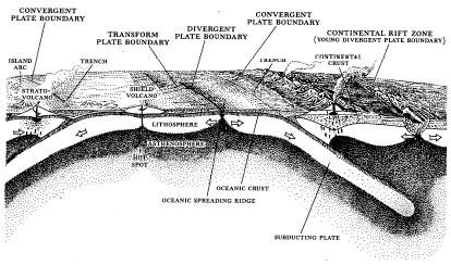
A subduction zone, like that responsible for the Sunda Strait eruption - and, indeed, for 95 per cent of the world's most violent volcanoes.
And dramas that also include the realization, which was published in an otherwise obscure book in 1980, that it is
... subduction along the Java Trench, where the Indo-Australian Plate is moving under the Indonesian island chain… that fuelled the 1883 eruption of Krakatoa.
The earth's surface appears to be armoured with between six and thirty-six of these rigid plates, depending upon how they are defined and counted. Many of the boundaries between plates have been drawn on the basis only of educated guesswork; what happens deep in the interior of China, for instance, where one plate is thought to meet another, has not yet been fully explained. Nor is it known what goes on around what is called the Scotia Arc in the chilly South Atlantic, east of the Falkland Islands. But, generally speaking, modern tectonics accepts the undisputed existence of about a dozen major plates. The boundaries between these, where the mechanics of the planet's architecture are best exhibited, are by now very well drawn.
Exactly what happens at the boundaries depends on a number of factors. If the plate is entirely of oceanic material - that is, basically basalt - and it collides more or less head-on with another plate of the same type, then there is an almost randomly decided subduction, with one plate indeed sliding beneath the other. An arc-shaped arrangement of small volcanic islands is usually created, the arc being shaped according to the way the plates move relative to one another. The chain of islands stretching along the International Date Line south of Tonga, for example, is a classic illustration of what happens when two oceanic plates bump into one another. For the purposes of this account, they are best overlooked.
If both plates are, on the other hand, composed mainly of continental material - which can best be thought of as a light scum of ancient granites and other sediments and metamorphic rocks lying on top of the oceanic basalts - then their collision may not result in a subduction at all. As the continental material is made up of lighter rocks, it generally resists being thrust down into the earth's subsurface; both plates may instead stay on top in line with one another, and buckle and crumple, forming a chain of mountains that is in most places not volcanic at all. India and Asia are a pair of continental plates that are colliding, for example - with the effect that the earth's crust where they smash into one another has crumpled itself up and more than doubled in thickness, to form the world's highest mountains, the Himalaya.
The Africa Plate is similarly moving slowly northwards and colliding with the Eurasian Plate. The highly unstable mountains of the Caucasus, the earthquake-prone hills of Turkey, the ever restless fracture zone of the Balkans, the ski-slopes of Iran's Mount Damavand are all a consequence of this entirely continental plate collision. But where there is some small amount of subduction, as near Vesuvius and Etna, there are volcanoes. Shallow-focus, very dangerous earthquakes are to be found everywhere along a continental collision zone: volcanoes are more likely where there is subduction.
It is also possible, given the complicated geometry of the earth, that two plates may well not hit each other head-on but slide alongside one another, like a tyre sliding past the kerb during a lame attempt at parking. The world's best-known example of this kind of meeting is the San Andreas Fault in California, notorious for what humankind regards as its capricious behaviour (a geologist would not think it capricious at all). It causes earthquakes in abundance and has enabled Hollywood to come up with some heroically awful films about volcanoes in Pasadena, tsunamis - lethally massive sea-waves - scooping surfers off Pebble Beach and faraway politicians uttering such droll slogans as the Coast is toast.
The Fault is a classic example of what is known as a conservative plate boundary, where there is no collision, no crumpling, no subduction. The immense Pacific Plate is here simply moving northward relative to the North American Plate, sliding along it at about half an inch a year. Extraordinary stresses can build up if this movement is somehow hindered - by friction, for example. And when this stress becomes overwhelming and is suddenly released, terrible earthquakes can and do occur. During the infamous San Francisco Earthquake of 1906 parts of the fault, which in recent years has accelerated its rate of sliding to almost four inches a year, shot past each other a total of twenty-one feet in a matter of twenty seconds!
Finally, and most importantly for the understanding of what happened at Krakatoa, there are those events that occur when two plates of different types collide - when one plate that is all oceanic basalt smashes itself into another plate that is loaded up with continental crust. These, so far as this story is concerned, are the important ones.
*
What takes place when plates of different composition run into one another, as might be expected (but was actually not, until that sudden realization made in 1967), is that the heavier of the two, the oceanic basalt plate, dips itself underneath the edge of the lighter continent-laden plate. Immediately it has started to do so, matters directly beneath the point of collision - matters within the classically formed subduction zone, that is - become complicated beyond belief and, to the geophysicist, endlessly fascinating. What takes place within the zone also has a profound effect on the making of the region above and on the lives of the human and animal inhabitants there - not least because, intermittently, the results of the plates' meeting and the making of a subduction zone can be very dangerous indeed.
In essence the process at a subduction zone begins when the colliding oceanic basalt plate begins to head off down back into the earth. It drags some of the continental plate down with it and, in doing so, causes a pinch - a trench - in the bed of the sea. In the case of Java, the five-mile-deep Java Trench, 200 miles off the coast, provides vivid evidence of the oceanic basalt plate as it begins barrelling its way downward. Behind the plate - the coral reefs of Cocos (Keeling) Island, Christmas Island, the flat blue Indian Ocean and, in the far distance, the coast of Australia - all is placid, paradisal, serene. In front of the down-racing plate is the Trench, a line of offshore islands, and then Java and Sumatra - one of the most volcanically unstable pairs of islands ever known.
They are unstable because of a well-understood, if wonderfully complicated, mechanism. The down-racing plate heads into the heat, dragging with it billions upon billions of tons of additional material - and, most crucially of all, water. This it gets from the huge thickness of the waterlogged sediments that are being dragged down from the seabed. Once this waterlogged material is stirred into the mix and reaches a critical depth, quite unexpectedly to those who first noticed the phenomenon, it begins to melt - doing so because the addition of this water has lowered the melting temperature of the mix.
And so what starts off beneath the seas as cold and solid now moves down towards the hot mantle, and turns viscous and runny; its fluid components begin to ‘sweat out’ - suddenly bubbling and frothing and coursing and, because they are light and volatile, so rising back up again, passing into the solid mantle through which all the downsliding ingredients had passed. To make matters more complicated still, as they course upwards through this material, they begin to melt that too.
Suddenly a Hadean nightmare is created miles beneath the subducted continental crust: immense volumes of boiling, gaseous, white-hot magma, alive with bubbles and energy and restless muscle, seethe in vaults and chambers of unimaginable size and temperature. The promethean material searches ceaselessly for some weakened spot in the crust above it. Every so often it finds one, a crack, crevice or fault, and then forces its way up into a holding chamber. Before long, the accumulating pressure of the uprushing material becomes too great, and the temperature too high, and the proportion of dissolved gas becomes too large, and it explodes out into the open air in a vicious cannonade of destruction. A type of volcano, which, because of its position at the edge of a subduction zone, is far more explosive and dangerous than any other of the world's many different kinds of volcano, suddenly - and if there are people around, invariably terrifyingly - erupts.
Two points of simple geography remain. The first is a matter of tectonic trivia. The Indo-Australian Plate, the culprit that creates all of the volcanic tamasha so notoriously present on Java, on Sumatra and on the tiny island that once lay between them in the Sunda Strait, is moving because the sea-floor south of Australia is spreading open. It is possible to calculate both the speed of that opening and the pole of rotation around which this spreading is taking place.
The speed of the sea-floor spreading, the rate at which the Indo-Australian Plate is moving northwards and colliding with the Eurasian Plate, seems to be about four inches a year, a hundred yards every millennium. Put another way: when Java Man - the Homo erectus who first came to these parts from Africa - was living in central Java about 1.7 million years ago, Australia and Asia were rather more than a hundred miles further apart than they are today. They have been moving towards each other ever since, and doing so in a direction that, unusual though it may seem, turns around a pole of rotation that is located a few miles to the south and east of the Egyptian capital, Cairo.
And secondly: there is one delightful symmetry that is noticeable, though imperfect at best and complex in the extreme, as more and more details become known. The tracks of the subduction zones that enfold the islands of Indonesia, the zones that create all the trenches and island arcs and volcanoes and mayhem that goes on among the islands of the archipelago, more or less follow the invisible line of biology and botany that was first hinted at by Philip Sclater in 1857 and drawn a year later by Alfred Russel Wallace.
On one side: Australia, cassowaries, emus and kangaroos. On the other: cows, monkeys, thrushes and elephants. On one side: the Indo-Australian Plate; on the other: the Eurasian Plate. The middle, where the two plates meet, and where they come together very slowly but with immense and unthinkable raw power, is in consequence a serried line of the world's greatest, most dangerous and most predictably unpredictable volcanoes - including, lurking just on the Asian side of an imagined extrapolation of the Wallace Line, the most demonstrably dangerous of them all, the once-great island of Krakatoa. It is an island that has exploded many more times than on the one occasion for which it is now so notorious.