A World Without Ice - Henry N. Pollack (2009)
Chapter 7. MELTING ICE, RISING SEAS
It is very difficult for someone living in the United
States to grasp the fact that if the sea level rises just a
few feet, a whole nation will disappear.
—BEN GRAHAM Ambassador to the United States from the Republic of the Marshall Islands
In the far reaches of the South Pacific Ocean sit many small islands—coral-fringed atolls that have formed on the subsiding calderas of extinct volcanoes. The growth of coral is fast enough to maintain the reef surface essentially at sea level, keeping pace with the slow geological subsidence of the ocean floor supporting the base of the volcano. Charles Darwin is best remembered for his compelling formulation of biological evolution, but he also was the first to recognize the role of volcanoes in the formation of coral atolls. Myriad low-lying islands in the South Pacific have been home to Polynesian, Melanesian, and Micronesian communities that have populated the islands for several thousands of years. These islanders have survived many challenges, including brutal occupation and warfare during World War II. But in the face of their newest challenge—rising sea levels from a warmer climate—these communities have no high ground to retreat to. Their only option is evacuation, mostly to places culturally alien to them. As Ambassador Graham says, it is indeed very difficult, and not only for Americans, to grasp the fact that if the sea level rises just a few feet, whole nations will disappear.
Tuvalu is a nation of twelve thousand people living on the atolls of the Ellice Islands, some two thousand miles north of New Zealand. Most of the islands sit only a few feet above sea level. Funafuti, the principal atoll, has an airstrip built by the United States during World War II. Today that lone runway provides the only easy connection with neighbors in Fiji and Samoa. But the airstrip has become increasingly vulnerable to partial inundation at the time of very high tides.87 Tidewa ter in an atoll does not just move inland from the shoreline—it seeps upward through the coral and soil from below. The slow rise of sea level due to climate change has given the tides a head start, so that at some time in this century even ordinary tides will begin to force water to the surface to form shallow tidal lakes. Tuvaluans for a while longer will live on a saturated sponge that gets squeezed with regularity. But within this century they probably will have to abandon their home.

CHANGES IN THE ICE, water, landscape, and life of Earth go hand in hand with a change in its climate. In the broadest of terms, a shift is now under way in the balance between ice and water—ice is diminishing, water increasing. In the parlance of Earth’s hydrological cycle described in chapter 2, we are witnessing a transfer of H2O from the solid cryosphere to the liquid hydrosphere. Mountain glaciers have been retreating, Arctic sea ice has been diminishing, the Greenland ice cap has been melting, permafrost has been shrinking, and sea level has been rising. And because of the continuing burning of fossil fuels, the greenhouse gas CO2 continues to increase in the atmosphere, bringing yet further warming. What will be the consequences of this continuing climatic trend in the near future? The answers to this question differ from place to place, and from one elevation to another.
It is a mistake, however, to think that climate change is some abstract characteristic of the future. To the contrary: changes in the climate have been taking place for decades, and are continuing into the future at an ever faster pace. Indeed, the many changes already observed in the natural world, along with the millions of temperature measurements in the atmosphere, oceans, and rocks, are what persuaded the IPCC to conclude in 2007 that the warming of Earth is unequivocal.
In most of the continental mid-latitudes, including the lower slopes of mountains, snow and ice make only seasonal appearances. Permanent snow and ice on mountains, of course, depends on where the mountain is located—on the Antarctic Peninsula permanent snow and ice begins at sea level, but in the contiguous states of America year-round mountain snowpack and glaciers are found only at high elevations—well above ten thousand feet—in Glacier and Rocky Mountain national parks, and atop Mounts Rainier and Olympus in Washington. In the polar regions, ice dominates the landscape at all elevations year-round.
As snow cover lessens and glacial ice melts, it will not be just the scenery that changes. Water for municipal systems and agriculture in the foot-hills and plains surrounding high mountains comes from melting of both the annual snowpack and much older glacial ice, residual from colder times of the past. This is the very water that millions of people drink from the tap, that flushes sewage from towns and cities, and that waters the crops in the fields. Meltwater derived from this snow and ice is well timed for agricultural purposes, coming in the spring planting and summer growing seasons. But in a warmer world, where instead of snow, precipitation comes as rain that runs off when it falls, the water is not stored for later delivery during the agricultural season. And when the glacial ice of the mountains is finally gone, that source of water will disappear forever.
SEASONAL SNOW AND ICE
Let us begin a tour of the diminishing domain of snow and ice at its most tenuous geographic margins, at those latitudes where snow covers the ground for only a few days at least once a year. Where wintertime temperatures are already hovering around the freezing point, a little warming will mean the end of an already short period of snow cover. This occurs not just because there are fewer days sufficiently cold for snow to fall, but also because the dark peripheral ground, covered less and less by snow, progressively absorbs more heat over the year, and impedes the snow that does fall from accumulating. The southern margin of annual snow occurrence in the United States and Europe is slowly shifting northward a few miles each decade. In the mid-twentieth century some winter snow in Memphis was never welcome, but not uncommon. Now, in the early twenty-first century, a snowless winter in Memphis is not so rare, but ice storms from freezing rain, even less welcome than snow, are more frequent. Over the past fifty years the area covered by snow in North America has diminished in all months except November and December. February used to be the month of maximum snow cover, but that honor now belongs to January.
Wherever precipitation is delicately balanced at the freezing point, freezing rain is just as likely as snow. As a result, the incidence of ice storms is at a maximum, along with the special inconveniences of downed tree branches and power lines, and glazed roadways that promote fender-bender collisions. And as the number of days when the temperature is below freezing declines and snow falls less frequently, there are adverse consequences for outdoor winter sports. Nowhere is this change in the snow regime being felt more than in the Alpine towns and villages of Switzerland, where the local economies are heavily dependent on winter tourism. In mountainous terrain the snowline is creeping upward about seventy feet per decade. Studies of snow depth and duration88 over the past sixty years show that a regime shift began in the late 1980s, when snow days declined by 20 to 60 percent. The reduction in snowfall coincided with an upward shift in the average wintertime temperatures, leaving little doubt about what was behind the diminished snowfall. The higher temperatures and the lesser amounts of snow have continued right through the first decade of the twenty-first century. Some Swiss ski slopes at vulnerable elevations are trying to preserve their wintertime snow and, in some cases the glacial ice beneath, with summertime plastic covers to shield them from the Sun. Ski resorts that make snow artificially because they are already challenged by inadequate natural snow are using their snowmakers more frequently, as they face the financial stress of a shorter natural season.
The warming of the waters in the Great Lakes of North America has led to later freezing and earlier melting of lake ice, as well as a diminished area with ice cover. The shorter period and smaller area of ice cover has had the consequence of increased loss of water due to more evaporation from the open lakes in winter. This has caused a drop of several feet in the lake levels over the past two decades, to a point where the upper Great Lakes—Superior, Michigan, and Huron—are approaching record lows. Lakeside cottages once a few steps away from the shoreline now see a beach a half-mile wide in some places, with wetland vegetation taking hold. And the entry channels to some major ports have become so shallow that without frequent dredging, they become impassable to the big freighters on the Great Lakes. These thousand-foot-long behemoths, were they at sea, would be too large to pass through the Panama Canal. In 2007, five fully loaded cargo ships ran aground attempting to enter the harbors at Muskegon and Grand Haven on the eastern shore of Lake Michigan. After being tugged free, they had to go across the lake to Milwaukee to off-load some cargo, before returning—floating higher—to unload the rest. The equally costly alternative is to carry a lighter load at the outset.
FROM THE MOUNTAINS
Long before humans came to the high Sierra Nevada of California, snowmelt fed streams tumbling through quartz veins containing gold, eroding and transporting the precious metal downstream. Where the currents slowed, the gold was dropped in the sand and gravel of the streambeds, later to be discovered by nineteenth-century prospectors. Today, it is the water itself that is the treasure—the snowmelt provides much of the annual agricultural water for California’s fertile Central Valley, which stretches from Sacramento to Bakersfield. The winter snows that have for years made Lake Tahoe a popular skiing destination and Squaw Valley the site of the 1960 Winter Olympics, undergo springtime melting to swell the Sacramento River and deliver water to thirsty vegetable and fruit farms in the Central Valley. A little farther south, the Merced River, with its source in the great glacially carved valleys of Yosemite, also heads downhill to irrigate another section of the Central Valley.
But what happens when more of the precipitation comes as rain instead of snow? That H2O is not stored in the winter snowpack—it does not wait for springtime to begin the downward journey to the dryer expanse of the Central Valley and then onward to the sea. Storage reservoirs along the way do not have the capacity to simply hold the water until later. So the water arrives much earlier than needed to help grow the produce of spring and summer, and when the agricultural calendar does call for delivery, the water is less abundant. A late-summer soil moisture deficit is a common result.
The dams and storage reservoirs along the waterways descending from the high Sierra serve another purpose—hydroelectric power generation. When water arrives early at already full reservoirs, it must bypass the dams via spillways. But every drop of water that bypasses the dams also bypasses the electric generators, the result of which is a deficit in power generation to accompany the deficit in soil moisture. If water is held in the reservoirs longer to provide steady hydroelectric power, the downstream flow is in places inadequate for agriculture and to maintain aquatic habitat for spawning salmon. The challenges of water management in an already semi-arid region are many. Within the larger expanse of the United States, water resources are already overallocated among agriculture, urban needs, ecosystem maintenance, hydroelectric energy, and recreation, at a time when demands in each sector are increasing.
In Europe, the Rhine River is fed in part by melting snow in the Alps and in part by rainfall over the low-lying parts of the river basin. A warming climate is changing the discharge of the Rhine to a rainfall-dominated regime—one of increasing winter flow and decreasing summer flow. The longer and more frequent low-flow episodes of summer are already apparent: less water for households, industry, agriculture, river transportation, and hydroelectric power during the time of peak summer demand.
Warming also shortens the snow season at both ends—winter snows begin later, and spring melting begins earlier. Already the peak stream flow from melting snowpack is appearing earlier in the season; by mid-century it is projected to arrive a full month earlier than the historical norms in the western United States.89 The seasonal shift in melting also leads to longer summers and longer dry seasons, with more opportunities for wildfires. Research on the wildfires in the American West has shown that an extended dry season translates into a more intense fire season, with more wildfires that burn longer.90
Contributing to the potential for wildfires are the large areas of forest succumbing to insect infestations in western North America. Vast areas of the pine forests in the western states and adjacent Canada are being decimated by the pine bark beetle.91 In British Columbia more than thirty-three million acres have already been lost, an area about the size of the state of Louisiana, and the infestation has spread to Montana, Wyoming, and Colorado. The beetle has crossed the Continental Divide into Alberta and is now making an appearance in the forests around the Great Lakes. This beetle is no stranger to the pine forests—it is not a recent invasive species—but the damage to the forests by it has grown dramatically in recent decades. What has happened? In the past, long and deep wintertime freezes controlled the bark beetle population, but now, with warmer winters and shorter deep freezes across the region, the beetle is suffering much less seasonal attrition. Greater numbers of hungry beetles are emerging each spring in search of nourishment, and the pine forests are their diet of choice. The dead trees then become fuel for wildfires.
Much higher on mid-latitude mountains, beyond the zone of seasonal snowpack, one encounters real glaciers, the streams of ice formed by compression and recrystallization of the snow of centuries past. In the contiguous United States these ice flows are few, principally atop Mount Rainier and other volcanic peaks in the Cascade Range of California, Oregon, and Washington, and in Glacier National Park in Montana. Most of these mid-latitude glaciers are remnants of the more extensive mountain glaciers of the last ice age. The extent of these former rivers of ice can be seen in the now-empty U-shaped valleys of the Sierra Nevada and Rocky mountains, as well as high up on the flanks of the Cascade Range volcanoes. All of these remaining patches of ice are shrinking—within the current century, Glacier National Park will lose the very features that give it its name.
In Alaska, a score of long ice streams radiate downward from the twenty-thousand-foot peak of Mount McKinley, in Denali National Park, but surveys of the Denali glaciers show they are thinning and retreating rapidly. At lower elevations, along the coast of the Gulf of Alaska and in Glacier Bay National Park, the glaciers delivering ice to the sea have felt the effects of climate change as well. In Glacier Bay, modern cruise ships today sail into the bay and up the fjords to the glacier fronts. Only two centuries ago, when explorer George Vancouver visited the area, the bay was almost completely frozen over and virtually inaccessible.
Earth is losing ice today even faster than during the warming that followed the Little Ice Age of the seventeenth and eighteenth centuries. Projections for the future indicate that it will likely continue to do so, and at an accelerating pace. Every decade for the foreseeable future will see the loss of more ice. Vulnerable places, such as high mountains in equatorial and temperate latitudes, will see ice vanish soon.
The Andes mountain range forms an impressive spine running the full length of western South America. The high peaks of the Andes, with summits near twenty thousand feet, are also sites where ancient ice is present and is replenished with annual snowfall. But over much of the extent of this long mountain range, the mountains form a curtain that captures atmospheric moisture at high altitude, leading to a deficit of rainfall at lower elevations.
For some two thousand miles along the Pacific margin of South America there is a coastal desert, broken only by thin green ribbons where rivers and streams bring water from the high ice fields and snowpack. The villages, towns, and cities on the western slope of the Andes in Peru and Chile are made possible by the water rushing down from melting snow and ice above. Fields of agriculture—the abundant fruit and flowers and the remarkable vineyards of the region—are possible only because of the meltwater from the high Andes. La Paz, the administrative capital of Bolivia, draws much of its municipal water and all of its electricity from glacial melt. Lima, the capital of Peru, and its port city of Callao rely on snowpack and glacial meltwater to flush the municipal sewage (much of it untreated) to the sea.
But the warming of the climate is imperiling this source of water. Mountain glaciers from Peru to Patagonia are losing their ice to a warmer world, and are on the path to disappearance within a few decades. The Quelccaya ice cap in Peru, the Chacaltaya Glacier in Bolivia, Perito Moreno of Argentina (flowing eastward on the other side of the Andes), San Rafael Glacier in Chile, the Darwin glaciers flowing out of the South Patagonia ice field into the Beagle Channel—all show an unmistakable loss of ice at a rate even faster than occurred when the region emerged from the last ice age. The extent of Andean ice today is less than the region has known for at least five thousand years, and is undergoing attrition at a pace not seen since humans took up residence along the Andes fourteen thousand years ago. In 2009 the World Bank published a report projecting that the imminent loss of Andean glaciers will affect the water supply of nearly eighty million people and significantly reduce hydroelectric energy production in the region.
Across the Atlantic, glacial ice has a toehold even in equatorial Africa, atop nineteen-thousand-foot Mount Kilimanjaro, well known from Ernest Hemingway’s “The Snows of Kilimanjaro.” But the toehold is slipping fast—Kilimanjaro has seen a decline in its glacial cap throughout the twentieth century, and will likely be ice-free by 2020.
The Himalaya mountain range of Asia, comprising the long, high, remote boundary between India and Pakistan on the south and the Tibetan Plateau of China to the north, is often called “the roof of the world” for good reason. The highest peak, Mount Everest, stands above twenty-nine thousand feet, and more than one hundred others exceed twenty-three thousand feet. No mountain on any other continent reaches that elevation. In Sanskrit, the word Himalaya means “home of the snow,” also for good reason. After Antarctica and the Arctic polar region, including Greenland, the ice mass on this Asian roof is the world’s third largest. More than fifteen thousand glaciers flow downward from the high Himalayas, with a combined ice volume equivalent to some three thousand cubic miles of freshwater.
Each year these glaciers yield meltwater that provides a little less than half of the annual flow volume of the Brahmaputra, Ganges, and Indus rivers, the three principal rivers of South Asia that flow to the sea across Bangladesh, India, and Pakistan. The other half of the flow comes from the annual monsoon rains and snowmelt from the high mountains. But the contributions to these rivers are not spread evenly over the year—the monsoon dominates during the rainy season, and glacial meltwater is the principal source of water during the dry months.
A long-term warming of the atmosphere is well documented in the region, and measurements of the extent of glacial ice leave no doubt that the glaciers of the Himalayas are melting, and at an accelerating rate over the past two decades.92 What message are these data delivering? Something akin to an urgent telegram that says that the volume of freshwater contained in the glacial ice of the Himalayas will last only another two to three decades. When the ice is largely depleted, the dry season flow of the Indus, Ganges, and Brahmaputra will diminish—already the lower Ganges is nearly empty for several months of the year. The lives of more than a billion people are intertwined with these rivers. Ironically, as the melting accelerates, there will be a temporary increase in water availability, until the shutoff arrives abruptly.
Ice on the Tibetan plateau north and east of the Himalaya also supplies the Irrawaddy and Mekong rivers flowing through Burma, Thailand, Cambodia, Laos, and Vietnam, and the Yellow and Yangtze rivers coursing through China. These rivers, too, face the loss of glacial meltwater in just a few decades hence. One of the principal glaciers feeding the Yangtze, the largest river in China, has retreated half a mile in a little more than a decade. The loss of the glacial water has grave implications for agriculture, urban drinking water and sanitation systems, and hydroelectric power generation. Seasonal water stress will become a reality on all sides of the Himalayas, a fact of life, or death. Taken altogether, one quarter of Earth’s population will within another decade be affected significantly by lesser snowfall and glacial ice loss. That number translates into almost two billion people—and most of them live in Asia.
Just as oil was the crucial resource of the twentieth century, water will be the prized resource of the twenty-first century. Already there is an international competition for water, and not just the decades-long tug-of-war between the United States and Mexico over Colorado River water. Nine nations share the Danube, six the Zambezi, four the Jordan. As politically charged a phrase as “the West Bank” is, one must remember that it is literally the west bank of the Jordan River. Water shortages are such a real threat for many nations that the potential for international conflict is also very real. In 2003 the Pentagon published a study of the implications of climate change for national security,93 and pointed to water shortages as a special factor in international instability: “Military confrontation may be triggered by a desperate need for natural resources such as energy, food and water rather than by conflicts over ideology, religion, or national honor.”
PERMAFROST
Farther north from the regions of simple seasonal snow cover the annual average temperature sits below the freezing point. There, aside from the summertime thawing of the upper foot or two—the “active zone” described in chapter 4—the ground is permanently frozen. This is the domain of permafrost. It extends over about 20 percent of Earth’s land surface, mostly in the sub-Arctic and Arctic regions of Asia, North America, and Europe.
Earth’s warming climate is taking a toll on permafrost terrains in many localities. As melting progresses to greater depths, the land surface suffers a disruption, stemming from the fact that ice occupies more volume than its equivalent melted water—the very same property that lets ice float on water. When deeper permafrost melts, the land surface above collapses into a jumbled irregular array of pits and hills. Houses and barns built on stable permanently frozen ground are undermined by ground subsidence; roads across the permafrost are broken up as if by an earthquake. Trees rooted in these slumping blocks are no longer vertical—their tilted orientation has earned them the description “drunken trees.” The jumbled terrain that results from the melting of permafrost is called thermokarst. It takes its name from the true karst topography, the landscape caused by slightly acidic groundwater dissolving limestone and producing sinkholes and collapses over subsurface cave systems.
The Alaska pipeline is a long forty-eight-inch-diameter tube, a giant conduit through which oil produced at Prudhoe Bay, on the Arctic coast of Alaska, is transported to the tanker seaport of Valdez, some eight hundred miles south on the Gulf of Alaska. Along many stretches of this long traverse, the pipeline passes over permafrost. The design and construction of the pipeline in the 1970s took into account that warm oil, pumped from deep below Earth’s surface, would melt the permafrost if the pipeline were buried in it. To avoid the possible buckling or breaking of a buried pipeline that melting permafrost might produce, engineers decided against burial. So for hundreds of miles the pipeline snakes across the tundra and through the boreal forest aboveground, perched on pedestals tall enough to let caribou wander unimpeded beneath.
Permafrost is something like concrete, in that the frozen water binds together soil, sand, gravel, and rock fragments. But when the permafrost melts, it releases the water and loses the cohesion that the ice provided. Rivers that drain into the Arctic Ocean—the Ob, Lena, Yenisei, and Kolyma—are showing increased flow volumes, and the Arctic Ocean is becoming less saline with the addition of the extra freshwater. The channels of the rivers themselves are becoming less stable, as formerly frozen riverbanks melt and collapse, releasing sediment that clogs channels and forces the rivers into new flow patterns that disrupt the already difficult challenges of life in the Arctic.
Melting permafrost, with its many sag ponds and exposed soil, is an important setting for the generation and release of gaseous methane to the atmosphere. The chemical composition of methane, CH4, is as simple as that of carbon dioxide, CO2, but methane is not a direct product of combustion. It is a fuel that is used for combustion, in kitchen stoves, in home furnaces and water heaters, in electrical generating plants, and indeed in some experimental automobiles. When methane is burned it produces CO2 and, in the process, liberates heat.
Why should we be concerned about methane escaping from permafrost to the atmosphere? It is because methane is another greenhouse gas that plays a significant role in controlling Earth’s climate. Once in the atmosphere, methane molecules—just like CO2 molecules—trap infrared radiation leaving Earth’s surface and warm the atmosphere. Methane is much less abundant in the atmosphere than CO2—its concentration is less than 2 ppm compared to the 390 ppm of CO2—but molecule for molecule methane is more than twenty times stronger in its infrared heat-trapping capacity than CO2.
Sergei Zimov is a Russian scientist working in the far northeast of Siberia, in a small structure on the tundra with the innocuous designation Northeast Science Station, well north of the Arctic Circle, near where the Kolyma River empties into the Arctic Ocean. It is far from Moscow, about as far as Atlanta is from Anchorage, or Denver from Honolulu, and light-years away in terms of amenities. Winter temperatures are routinely -40º Fahrenheit, and the summer sky is clouded by mosquitoes. Recall that it was the mouth of the Kolyma River that Vitus Bering failed to reach in 1728 because of worries about being trapped in sea ice that begins to form there in September. Zimov and his wife, Galina, have been “trapped” there, voluntarily, for almost thirty years, observing the beginning of the end of the Arctic permafrost.94 Their son, Nikita, was born there, and he is now part of the family scientific team, much like the three-generational Kozhov family team on Lake Baikal mentioned in chapter 4.
An area of western Siberia the size of Texas and California together has begun to melt from the top down. As another unheralded “Cinderella scientist” doggedly collecting scientific data, Zimov has recently been monitoring the methane bubbling up in the thaw lakes. The soil in regions of permafrost is effectively virgin and carbon-rich, the product of many episodes of tundra development between multiple glacial episodes over the past few million years. It is a very fertile soil for microbial generation of methane, now and in the distant past. Long inert in its frozen state, the methane has now been awakened by the warming of the Arctic. Zimov and other scientists who have come to join him on the tundra have found that the volume of methane and its rate of release are much greater than previously anticipated. And some of the methane is tens of thousands of years old, released from its long entrapment in the permafrost by the recent warming.95
Methane is also produced by other natural processes, in different environments and on shorter time scales. It escapes to the atmosphere from wetlands, peat bogs, and rice paddies. The common denominator of these botanical methanogenic locations is soggy organic soils, where microbial activity unites the carbon in the wet soil with hydrogen to produce methane. It is a particularly effective process when the microbes are isolated from atmospheric oxygen—in places deep within the soil or in the muck at the bottom of lakes. Domestic herd animals also release methane at the terminus of their digestive tract, a process that in polite circles is referred to as “bovine flatulence.” As dietary preferences around the world shift toward meat, this source of methane is growing.
Indeed, monitoring stations worldwide have shown a steady increase in atmospheric methane in the latter decades of the twentieth century, due both to increased rice cultivation and to the degrading permafrost. In the mid-1970s the methane reached double its preindustrial level, and today it stands at 2.7 times preindustrial. The rate of growth slowed briefly between 2000 and 2007, but has now resumed a rapid growth rate.96 And the permafrost continues to degrade. Fortunately, it takes a long time for warming at the surface to penetrate to greater depths—permafrost five hundred feet down would be unaware of surface temperature changes over the past century, so slow is the downward propagation of thermal disturbances. The bad news, however, is that even if warming of the surface were to end today, the earlier warming would continue to diffuse into previously undisturbed permafrost. The unabated addition of methane to the atmosphere of course creates a positive feedback loop, accelerating the melting and release of more methane from the no-longer-permanent permafrost. And so this potent cycle of reinforcement continues to ratchet the warming of the Arctic upward.
ARCTIC SEA ICE
All along the northern margins of the degrading Arctic permafrost, in Scandinavia, Russia, Alaska, Canada, and Greenland, one encoun-ters the sea ice of the Arctic Ocean, described earlier in chapters 2 and 4. Historically, sea ice covered almost the entire ocean in winter, save for the occasional polynya.97 Summertime saw some retreat, with about a third of the sea ice melting and breaking up. But large areas escaped breakup, and continued to block navigation. Explorers probing for pathways through the Arctic Ocean repeatedly met vast expanses of sea ice. For centuries the Arctic was virtually impenetrable to seagoing vessels.
Earth-orbiting satellites, launched in the late 1970s, offered the first synoptic views of the Arctic sea ice in its entirety. In earlier decades, the distribution of sea ice was gathered piecemeal from Arctic research stations, occasional areal photography, and from below the ice by American and Soviet submarines. These observations have shown that the summertime retreat and winter refreezing of sea ice were regular occurrences throughout the twentieth century, with little change in the extent of the summer ice loss. In the 1980s and 1990s, however, the summer melting and breakup began to consume more ice, until by the end of the twentieth century the summer sea ice extended over only 75 percent of the area it had covered at mid-century. Perennial ice, the older multi-year ice that survived the summer melting and breakup, was also diminishing at a rate of about 10 percent per decade. The winter refreezing replaced the older ice with first-year ice, and so the Arctic sea ice on average is becoming younger and thinner. The average thickness of the sea ice at the end of the century was reduced to about half its mid-century thickness. By 2007, summer sea ice was again down—to an area only 60 percent of its long-term average,98 an all-time low since records have been kept.
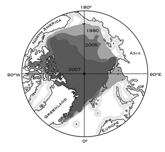
A map of the Arctic showing the reduction in summer
sea ice that has taken place since 1980. Data from the
University of Illinois, Urbana-Champaign
The area of sea ice lost since 1980 was half again greater than the entire area of the United States east of the Mississippi River. Taking into account changes in both area and thickness, almost 90 percent of the mass of summer sea ice over much of the twentieth century had disappeared by 2007. In 2006-7 the French ship Tara replicated the late-nineteenth-century drift of the Norwegian ship Fram across the Arctic Ocean, locked in sea ice. But Tara completed the drift in only five hundred days, compared to the three-year drift of Fram; the shorter drift time of Tara was attributed to the greater ease with which thinner sea ice can move across the ocean. In 2008, perhaps for the first time in many centuries, both the Northwest and Northeast passages were open at the same time.
The current rate of summer sea ice loss is exceeding all projections,99 and there is a very real possibility that in only a few decades the Arctic Ocean may be ice-free in the summer, for the first time in fifty-five million years. Climate scientist Ian Howat of Ohio State University remarked that the loss of Arctic sea ice might be the largest change in Earth’s surface that humans have ever observed.100
ARCTIC SEA ICE typically takes the brunt of punishing ocean waves and storms, but as the ice has all but disappeared in the late Arctic summer, the exposed coastline has become vulnerable to severe erosion. Villages in the Arctic have traditionally been built close to the sea to enable easy pursuit of seals, walruses, and fish. But the loss of shoreline protection has taken a toll on structures built near the sea. Shishmaref, Alaska, a small community with fewer than six hundred residents built on a small island in the Bering Strait, is facing the possibility of forced evacuation. Shishmaref has had human inhabitants for several thousand years, but it has always had the protection and convenience of surrounding sea ice during the storm season. In recent years, however, storms have time and again eroded the island. Shishmaref is literally losing ground, and the residents have had to relocate houses farther from the shoreline. Travel to the mainland for hunting moose and caribou, formerly easily accessible over the sea ice, has been impeded because the winter freeze of the sea has recently been delayed by as much as six weeks.
Just east of the Alaska-Canada border, along the coast of the Beau-fort Sea, sits Tuktoyaktuk, a Canadian port town. The terrain of the area is low-lying, with little topographic relief. Sea ice formerly offered protection from big waves and storm surges, but today, erosion in Tuktoyaktuk is an increasing problem. As in Shishmaref, buildings are being abandoned to the encroaching sea. Multiple attempts at engineering shoreline protection have failed, in a losing battle with the advancing surf. Most of the coast surrounding the Arctic Ocean is increasingly vulnerable to destabilization, because the seawater accelerates the melting and destruction of the coastal permafrost and leads to the development of thermokarst. The temperature of seawater is clearly above the melting point of ice, and so contact between seawater and permafrost leads to rapid degradation.
It is not only the hunters on Shishmaref who have seen the loss of sea ice cut them off from large game. Polar bears are also affected. For years sea ice has served as a widespread platform for polar bears to move about in search of food, particularly the seals of the Arctic Ocean. Pregnant female bears spend winter in dens of snow and ice, emerging in spring after a half year without food, and with a new family of hungry cubs. An early breakup of the sea ice impedes their ability to hunt, forcing them to walk less and swim more in search of seals, a bad trade-off in terms of energy expended. Reproductive success is closely tied to the fitness of the mother—weakened females produce fewer and smaller cubs. Multidecadal studies of polar bears in the Hudson Bay area reveal declines both in average parental weight and in the number and weight of cubs. And the sea ice is breaking up a week earlier each decade.
Though stronger swimmers than the bears, the seals are faring no better. They, too, use the sea ice as a platform at calving time, and an early breakup of the ice leads to a premature separation of parents from the newborn, before the young seals are ready to face the world on their own. Walrus also rest on sea ice as they scavenge the shallow near-shore seafloor, but as the edge of the sea ice moves to deeper water, the walrus is faced with more arduous seafloor foraging.
MEANWHILE, AT THE BOTTOM OF THE WORLD …
Palmer Station, one of three U.S. research stations in Antarctica, was built on Anvers Island, along the Antarctic Peninsula, in 1968. It comprises a handful of prefabricated buildings that host research projects, a small boat anchorage, fuel storage tanks, and living and dining quarters for some forty people. The station, named for the early-nineteenth-century American sealer and explorer Nathaniel Palmer, is chiseled into a rocky outcrop, squeezed between the large Marr Glacier and the open sea. From the air the station is dwarfed by the vastness of the peninsular ice and the ocean that surround it. The research focus at Palmer is largely biological, but includes a seismographic installation and a meteorological station.
Since 1950, the Antarctic Peninsula has warmed by more than six Fahrenheit degrees, mostly due to a remarkable rise in wintertime temperatures of more than ten Fahrenheit degrees. This warming has reduced the extent of winter sea ice along the western edge of the peninsula by 40 percent and shortened the duration of sea ice cover there by almost three months. These changes in the sea ice along the peninsula are leading to changes in the ecology of the rich marine life of the region. But the changes begin not with the big animals—the whales, seals, and penguins—but rather at the bottom of the food chain, with the marine phytoplankton. Phytoplankton are single-cell plants that fuel their growth with sunlight. They flourish near the margin of the sea ice that grips much of the Antarctic Peninsula each winter. When spring arrives and the sea ice begins to break up, the phytoplankton bloom pro lifically. They are then devoured by small shrimplike crustacean called krill, which are in turn the diet of choice for penguins and whales farther up the food chain.
If the warming trend of the peninsula continues, by 2050 midwinter temperatures will remain warmer than the freezing point of seawater, and sea ice will not form. Jim McClintock, a professor of polar and marine biology at the University of Alabama at Birmingham and a long-time researcher at Palmer, says that the warming will lead “to a regime change in the ecosystem. Krill are highly dependent on sea ice; without it they cannot complete their life cycle and breed successfully.” The decline of sea ice in area and duration is particularly ominous for the krill, and for the penguins that eat them, and for the predatory seabirds that eat the penguin eggs and chicks, and so on, up the food chain. At the top of the list are the whales, which don’t depend upon or even bother with the intermediate links in the food chain—they eat krill directly, by the ton every day.
One long-term study at Palmer has focused on the population dynamics of the three penguin species in the area—the Adélie, Gentoo, and Chinstrap. McClintock and colleagues Bill Fraser and Hugh Ducklow have pieced together the interdependencies of these penguins with the changing environment.101 Because each species interacts with sea ice in different ways, principally in their access to food, the changes in the ice are driving the populations in different directions. Adélie penguins, the classic little tuxedo-clad seabirds, prefer wintertime foraging at offshore locations where nutrient-rich marine upwellings occur, sites made more accessible to them by the existence of widespread sea ice. By contrast, Chinstrap and Gentoo penguins prefer to forage along open shorelines. The declining sea ice has therefore been hard on the Adélies but generous to the Chinstraps and Gentoos.
I have been to Palmer Station four times over eighteen years. When I first visited in 1991 there was a big Adélie population on the islands around Palmer—noisy, smelly, coming, going. But on my most recent stop, in early 2008, the Adélies were largely gone. Indeed, all along the northern half of the peninsula, Adélie populations are in decline. Deciphering these trends would not have been possible without year-in, year-out monitoring of the penguin populations, the sea ice extent and timing, and temperature and precipitation changes. The U.S. National Science Foundation has designated Palmer Station a Long-Term Ecological Research (LTER) site, a designation that assures funding for the long-term observational programs that track trends in the ecosystems. The NSF has established twenty-six LTERs, three of which are in polar regions—one on the north slope of Alaska and two in Antarctica.
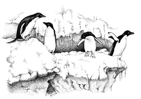
Adélie penguins of Antarctica
ENCROACHMENT OF THE SEA
The most dramatic consequence of a world losing its ice will be the steady—and perhaps not so steady—rise of sea level. For the entire twentieth century and continuing into the twenty-first, sea level has been creeping upward, due to two principal causes. The first relates to some simple physics—seawater expands as ocean temperatures rise. The second is the return of meltwater to the ocean, after spending thousands of years as ice in temporary residence on the continents. Both causes lead to encroachment of the sea onto the land. There is already more water on Earth than can be accommodated in the deep ocean basins, and the excess has spread out to cover part of the continental shelves. As sea level continues to rise, foot by foot, shorelines will relocate inland.
The IPCC has estimated the likely sea level rise in the present century to be in the range of ten to thirty inches, which, when added to the eight-inch rise of the previous century, indicates that we are facing an increase of some two to three feet above the historic average sea level. Such numbers may seem modest, but in fact changes of that magnitude will have nontrivial consequences in shoreline erosion, infrastructure destruction, and population displacement. In making these estimates, the IPCC considered only the effects of continued thermal expansion of ocean water, the addition of new water by melting and runoff of continental ice, and the return of some groundwater to the sea. But the IPCC hedged their projections with one important caveat that I will return to shortly.
Low-lying places on Earth—those barely a foot or two above today’s sea level—will be the first to feel the encroachment of the sea. The barrier islands and very gently sloping coastal plains along the Atlantic and Gulf coasts, many coral-fringed atolls of the Pacific, and major river deltas the world over are particularly vulnerable to a rising sea. These are the places that already take the brunt of storms and hurricanes. Almost every structure on the barrier islands at Galveston on the Texas Gulf coast was leveled by the winds and storm surge of Hurricane Ike in 2008, and as sea level creeps upward, these islands will be increasingly vulnerable to even lesser storms.
Along the Atlantic coast of the Carolinas, Georgia, and Florida there is a continuing struggle between the erosion and shifting sands of the barrier islands and the ever-increasing number of people who build houses on them. The houses are expensive, and so is the struggle—dredging sand to keep established channels open, trucking in sand to replace the beaches lost in storms. And there is always the temptation toward “hard stabilization”—the building of protective seawalls and other types of barriers—which almost always fail, leaving a massive jumble of concrete debris with bent steel reinforcing rods to degrade the landscape, in mute testimony to the futile attempt at forestalling nature.
Well before rising waters force abandonment of coastal and barrier island homes, the residents will also notice that their well water has turned briny, as a result of seawater pushing into coastal aquifers. Shortly thereafter sewage systems will begin to fail as seawater degrades bacterial action. Little of Florida from the Everglades south through the Keys sits more than three feet above sea level. During the storm surge of Hurricane Wilma in 2005, many of the Keys were under three feet of water and more than half the houses in Key West were flooded. Every part of this region is vulnerable to even a modest rise in sea level.
The levees that channel the Mississippi River through New Orleans are an example of hard stabilization. These mounds of earth and concrete walls are massive constructs designed and engineered by the U.S. Army Corps of Engineers. New Orleans does not sit a foot or two above sea level—much of the city is several feet below sea level. The life of New Orleans has for decades been entrusted to the levees, a trust that was betrayed during Hurricane Katrina in 2005. Katrina forced the evacuation of some 150,000 residents of New Orleans, and many never returned. Despite some post-Katrina repairs, there was another near-betrayal during Hurricane Gustav in 2008, when the storm surge lapped at the very top of New Orleans’s floodwalls, splashing over with any slight provocation from the wind. Gustav was not the storm that Katrina was, but had sea level been only a foot higher, Gustav would have replicated what Katrina wrought. The slowly rising seas of the twenty-first century will make any hurricane a danger to New Orleans.
Venice is built on several islands in a marshy lagoon at the north end of the Adriatic Sea. The city proper and other occupied islands in the lagoon are home to one hundred thousand people. The canals of Venice lead to the open sea, and are only one indication that the city and the sea are like hand and glove. Piazza San Marco, perhaps Venice’s premier tourist destination, is vulnerable to flooding from a multitude of causes—stiff winds from the sea, high tides, or intense rainfall. In early December of 2008 all three conspired to place St. Mark’s thigh deep in water, a level within the range of the IPCC estimates of sea-level rise this century. With sea level creeping higher, Venice will be visited more frequently by flooding, even in the absence of a triple conspiracy. Authorities in Venice have long dreamed of building a flood barrier at the mouth of the city’s lagoon to hold back the Adriatic at times of high tides and wind-driven water, but the costs to build the barrier have escalated faster than the available money. And meanwhile, sea level keeps rising.
Kiribati is an island nation in the south Pacific, with some ninety thousand citizens scattered on more than thirty atolls straddling the equator. Its principal community is on Tarawa atoll, the site of a ferocious struggle between the Japanese and Americans during World War II. Kiribati will be another of the countries that, like Tuvalu, will lose territory to rising sea level. Already many places are experiencing flooding, erosion, and saltwater contamination of the groundwater at the time of the twice-monthly high spring tide. In 2008, Kiribati asked Australia and New Zealand to open their doors to Kiribati citizens as permanent climate refugees. Kiribatians worry that no matter how the large industrial countries might attempt to prevent future climate change the oceans will continue to warm and sea level will continue to rise because of the long-lived greenhouse gases already in the atmosphere.
The Maldive Islands are an archipelago of twenty-six atolls in the Indian Ocean, south of the southern tip of India. Most are about three feet above today’s sea level; none reaches more than seven feet. That topographic fact gives the Maldives the honor of being at the bottom of the list of nations ranked by their maximum elevation. Some 350,000 people reside in the Maldives, about one third in the capital city of Malé. Seawalls completely surround Malé for protection. Perhaps more prosperous than many island nations, the Maldives are thinking about creating an investment fund to buy land in India, Sri Lanka, or elsewhere as a destination for climate refugees. The Maldives recently experienced the devastation of higher seas when the tsunami associated with the 2004 Indonesian earthquake literally rolled over many of the islands.
THE DELTAS
Most rivers flow to the sea, completing the hydrological cycle by returning water evaporated earlier from the oceans. But big rivers also carry vast amounts of sediment eroded from the land. Deltas are geologically dynamic meeting places—where rivers and their sediment load meet the sea. When a river flows into the sea its current is slowed and the sediment settles. Over time the channel wanders back and forth over the accumulating pile of sediments to form a delta. The Greek letter delta (Δ) has the shape of a triangle, and is an appropriate descriptive term for the broad fan of sediment that rivers dump into the sea at their mouths. The deltas of Earth’s major rivers—the Amazon, Ganges, Nile, Mississippi—extend over hundreds of miles, some parts slightly above sea level, others slightly below. Over time, some mud banks and sand-bars will slowly sink below the surface, while other areas receive enough sediment to rise slightly above the sea and feel the sunshine for a few decades.
The Nile Delta meets the Mediterranean Sea along a 150-mile shoreline, about a hundred miles north of the apex of the delta where the river emerges onto the delta from its narrow floodplain after a long meandering journey across the Egyptian desert. Along the coast of the delta at its western edge sits the ancient and modern city of Alexandria, home to more than four million people. Much of the historic ancient city is now submerged beneath the sea, largely due to tectonic subsidence of the land associated with regional earthquakes. Alexandria’s El Nouzha International Airport itself sits six feet below sea level, isolated from the sea by natural barriers.
The soil of the Nile Delta is very rich, and accordingly, rural parts of the Nile Delta are heavily agricultural. Over much of the history of the Nile, the sediment of the delta was replenished by the annual flood of the river, but since the completion of the Aswan High Dam in 1970, six hundred miles south of the delta, the annual flood no longer occurs along the lower Nile. The soil of the delta now requires fertilizers to maintain productivity. But the delta itself, no longer replenished with sediment from Africa’s interior, is slowly retreating as shoreline erosion along the Mediterranean inexorably eats away at the delta’s margin. And as seawater pushes its way into the subsurface aquifers, the groundwater in the delta is becoming more brackish. The erosion of agricultural land and the intrusion of saltwater will only accelerate as sea level rises due to climate change.
The Bengal region of eastern India and the adjacent country of Bangladesh sit astride the immense delta built by the Ganges and Brahmaputra rivers. These two rivers, both with headwaters in the Himalayas, drain a sizable fraction of Asian territory and deliver to the delta a heavy load of sediment eroded from the mountains. This area, with its large cities of Calcutta and Dhaka, has one of the world’s highest population densities, on some of the lowest terrain. Calcutta, located some sixty miles from the Indian Ocean, has more than eight million residents, and its lower precincts are only five feet above sea level. Much of the coastal south of this huge delta is only a foot or two above sea level. It is a great oversimplification to speak of a coastline—the actual margin of the land with the ocean is like a giant frond, with bays and marshes extending far inland, separated by tongues of land that do not qualify for the adjective dry. Seasonally, about 10 percent of Bangladesh is underwater.
The terrain of the Ganges Delta is about as flat as one can find, rising only a foot above the sea for every twelve miles inland from the coast. By comparison, the Great Plains stretching across Kansas and Nebraska to the mountains of Colorado are a steep ramp, rising by about eight feet for each mile they sit westward of the Missouri River. A slope of one degree, which we might imagine to be a very small slope, rises ninety feet in a mile. A sea-level rise of a foot or two in this century—the conservative projection of the IPCC—will force a devastating displacement of millions of people living on the Ganges Delta.
The numbers are sobering—11,000 Tuvaluans, 60,000 Marshall Islanders, 90,000 Kiribatis, 100,000 Venetians, 150,000 people in the Big Easy, and millions in the deltas of the Nile and Ganges—all facing displacement by only a modest rise in sea level. A recent study102 of where people live on Earth showed that 108 million humans, equivalent to the population of Mexico, live on terrain no more than three feet above sea level. Those numbers translate into 1.6 percent of Earth’s population living on less than 1 percent of the land surface—that part of the land barely above sea level. In the United States along the Atlantic and Gulf coastal plain and barrier islands, more than 2.5 million people live no more than three feet above sea level.
Hurricane Katrina displaced about 150,000 people from New Orleans, and the 2008 California wildfires displaced almost 1 million—and both events severely tested our nation’s ability to address the needs of environmental refugees. Cyclone Sidr, a November 2007 tropical storm in the Indian Ocean, killed more than 3,000 Bangladeshis and left more than one million homeless, with the full consequences of that population dislocation still to be determined. A three-foot rise in sea level this century, creating more than one hundred million climate refugees, is equivalent to about seven Katrina-scale evacuations every year, although much of the population displacement will occur later in this century.
In rich nations, much effort and treasure will be expended to forestall and avoid the advance of the sea. Levees will be strengthened, seawalls will be built, but most of the effort will be futile—it is almost impossible to hold back the sea along an extended coastline. The masters of that craft, the Dutch, already have recognized the near impossibility of the task, and have made plans to abandon some of their land to the rising sea. In poor nations, people will simply be forced to move to higher ground, ground already occupied by other people, who are unlikely to welcome the newcomers. If immigration now seems to be a thorny, controversial, and emotional problem in the United States and Europe, after three feet of sea-level rise and one hundred million climate refugees worldwide, today’s immigration complexities will in retrospect look like a Sunday school picnic.
It is entirely possible that sea-level rise will not continue at the slow and steady rate we have experienced in the twentieth century. As seawater warms, its ability to take in CO2 from the atmosphere diminishes because the solubility of CO2 in seawater decreases as the temperature of the water increases. The likely result will be that in the present century, as the oceans continue to warm, they will be less of a sponge for atmospheric carbon dioxide. More CO2 will remain in the atmosphere and enhance the heat-trapping greenhouse—thus accelerating the melting of land ice, and the warming and thermal expansion of the ocean water. And the physical mechanisms that cause water to expand are more effective at higher temperatures than at cooler temperatures. The physics and chemistry of the oceans and atmosphere make inescapable the conclusion that a warmer Earth will lead to sea level rising at an accelerating pace. Already the rate at which the sea was observed to rise in the period 1993-2003 exceeded the average rate over the longer period 1961-2003 by more than 50 percent.
THE THIRD TRENCH OF DENIAL
The climate contras have occupied several successive defensive trenches in their campaign of denial of anthropogenic climate change. The first trench was simply that of disputing the many observations that climate has been changing. The second was that if climate has been changing, the change has been due entirely to natural causes—that humans have had no essential role in climate change. Although some contras remain active along these lines of defense, many have retreated to a third trench: Who, they ask, will be unhappy with a CO2-rich atmosphere and a warming world? They point out that CO2 acts as a fertilizer, stimulating agriculture around the world, and that a warmer world will extend the growing season and enable more food production. And they muse about the pleasures of milder winters, free from the hassles of snow and ice. In their more rhapsodic moments they speak of a return to the Garden of Eden.
Indeed, the growing season is growing—in Alaska it is already two weeks longer than a half century ago. And it is true that CO2 is a necessary ingredient for photosynthesis. But CO2 alone is not sufficient for increased plant growth. Frequently in natural settings it is the availability of other nutrients—particularly water and nitrogen—that are the limits to additional biomass, not the availability of CO2. Controlled experiments at Duke University’s Duke Forest showed that elevated levels of CO2 produced no incremental growth in trees rooted in nutrient-poor soil.103
Moreover, in nature, CO2 does not vary in isolation. In a greenhouse-forced climate change, higher temperatures and changed geographic patterns of precipitation and soil moisture accompany an increase in atmospheric CO2. In one of nature’s own experiments, the boreal forest in Alaska has not shown dramatic growth as the atmospheric CO2 has increased because it is also experiencing heat stress from the warming climate. And the pine forests of western North America, far from flourishing in a higher CO2 atmosphere, are suffering terribly from a resurgence of the pine bark beetle, a pest formerly kept under control by colder winters.
CO2 is not a discriminating fertilizer—it fertilizes weeds as well as foodstuffs. And there is nothing to guarantee that the crop growth we might want to enhance will be able to outpace unwelcome invasive insects and plant species that also like the warmer and CO2-richer atmosphere. If a greater use of herbicides and pesticides to control invasive species follows, the negative effects on public health and the general ecosystem will diminish whatever benefits might come from CO2 fertilization.
The rhetorical question “Who wouldn’t welcome warmer winters?” is both parochial and simplistic. It implicitly assumes that a warming that would ameliorate winter cold, snow, and ice in the latitudes where those phenomena occur would be welcomed also by the majority of Earth’s population who do not live in that environment. Higher temperatures in already warm regions are not high on the wish list of those who live there. And of course a long-term trend toward warmer winters does not occur independently of changes in the other seasons—such a trend is often accompanied by a similar trend to warmer summers, with more heat waves and soil desiccation. The IPCC assessment of impacts accompanying a warming world shows that the tropics will fare poorly by almost any measure.
Even were there to be some regional benefits in the early stages of moderate climate change, as there well might be in some mid-latitude settings, those selective and limited benefits hardly outweigh the large-scale hardships and human displacement associated with even a modest rise in sea level. Higher seas will affect almost all of the world’s coastlines adversely—large nations and small, rich nations and poor. There is no way that rising sea level can be described as beneficial.
THREE FEET OF SEA-LEVEL rise, however, may be just the beginning. The ongoing breakup of Antarctic ice shelves—the Larsen, Wilkins, and Ronne along the Antarctic Peninsula, and the Ross Ice Shelf farther around the continent to the west—has ominous implications for sea levels globally. These floating shelves of ice, in place for thousands of years, form buttresses that bottle up glacial ice on the land of the peninsula and West Antarctica, slowing spillage of ice into the sea. Those long-standing buttresses are now breaking away, and the glaciers are speeding up their delivery of land ice to the ocean.
When ice flows off the land and enters the sea for the first time, it raises sea level. It is nothing more than a large-scale replication of the process that takes place when you drop an ice cube into a glass of water. The submerged part of the floating cube displaces water and moves it aside, and up, in the glass. Once afloat in the glass, however, ice causes no further change in the water level as it melts. The same holds true for floating ice shelves—when they break up and melt, they do not change sea level because the effect of the floating ice on sea level occurred when the ice originally spilled out onto the sea. But the breakup of the shelves is an early warning sign, an icy “canary in the coal mine,” because the breakup allows new land ice to spill into the sea, and the new ice does raise sea level.
The mass of ice bottled-up on the Antarctic Peninsula, were it to slide into the sea, would raise the global sea level about ten inches, roughly equivalent to the cumulative sea-level change observed during the twentieth century. However, the twentieth-century sea-level change was due principally to the warming and thermal expansion of the seawater globally, and to some new water added to the oceans from the melting of mountain glaciers and permafrost. Those were relatively slow processes in the twentieth century. But when ice is dropped directly into the ocean, the sea-level change takes place right away, before the ice melts. That is why an acceleration of ice loss from Antarctica and Greenland is worrisome—sea-level changes can come much more quickly than the relatively slow increases arising from warming alone.
The amount of ice on each of the Greenland and West Antarctic landmasses is equivalent to about twenty feet of sea level change, and that on East Antarctica, about two hundred feet. Because much of the ice surface on East Antarctica is remote from the sea and very high, the temperature is extremely cold. It averages about -50º to -60º Fahrenheit over the year, and never gets close to melting, even in summer. Of all the ice on the globe, that in East Antarctica is thought to be the most stable. But Greenland and West Antarctica present a more ominous scenario.
GREENLAND
As the Arctic has warmed, summertime melting has been creeping to higher elevations on the Greenland ice cap. Some of the meltwater runs to the sea, and some ponds up in slight depressions to form blue lakes on the surface of the white ice. Occasionally these meltwater lakes disappear suddenly, draining into large fissures called moulins, which apparently penetrate the entire mile-thick ice sheet. Meltwater plunges to the base of the ice and makes its way along the interface between the rock and ice, much like subterranean rivers that flow deep within limestone caves.
The consequence of this deep subglacial flow is profound—the water lubricates the base of the ice sheet, allowing the ice to slip toward the sea at a faster rate.104 The Jakobshavn Glacier, on the western coast of Greenland, is the largest drainage channel for interior ice—it alone accounts for about 6.5 percent of Greenland’s ice delivery to the sea. Between 1983 and 1997 the ice moved down valley at a speed of three to four miles per year, but then it rapidly increased, reaching about seven to eight miles per year in 2003.105 An investigation of all the glaciers draining Greenland106 revealed widespread acceleration of ice loss between 1996 and 2005, first in the south, then steadily moving north. In that decade, Greenland revealed an annual ice deficit—yearly ice losses that exceeded the annual replenishment by snowfall—that more than doubled.
The accelerated ice movement is redefining the phrase “at a glacial pace.” The slow flow of ice is similar to the slow creep of Silly Putty down a gentle slope. Both ice and Silly Putty, although solid, yield to the pull of gravity through slow plastic deformation in their interiors. But ice complains when “a glacial pace” is scaled upward—it literally creaks and groans as gravity pulls it downward at a faster pace. Already this disequilibrium is manifesting itself with the appearance of ice quakes, small seismic disturbances created as the ice adjusts internally to the changing velocity of flow, and as it squeezes its way over or past irregularities in the rock surface below.
WEST ANTARCTICA
West Antarctica is capped with an immense mound of ice about a mile high and a thousand miles across. From the top of the mound the ice flows in three directions—to the Ronne Ice Shelf in the Weddell Sea, to the Ross Ice Shelf, and to the Amundsen Sea. Both the Ronne and Ross ice shelves, even though losing some ice on their seaward margins, have remained effective buttresses to the ice streams feeding them. But the two principal glaciers carrying most of the ice flow from West Antarctica to the Amundsen Sea are showing dramatic acceleration. The Pine Island and Thwaites glaciers are not typical Alpine glaciers that flow a few tens of miles in valleys a mile or so across. Multiply those dimensions by ten to envision the immense scale of the Pine Island and Thwaites glaciers. These ice streams, each tens of miles wide and up to a mile thick, flow for hundreds of miles from the top of the West Antarctic ice pile to the sea. The scale is difficult to appreciate—imagine the entire Mississippi River floodplain from Memphis to New Orleans filled with ice several thousand feet thick, slipping southward to the Gulf of Mexico at the glacial pace of about a mile each year. These glacial streams drain an area that would contribute about five of the twenty feet of the potential sea-level rise represented in all the ice of West Antarctica. And the discharge from these glaciers has been speeding up.
The ice shelf fed by these glaciers, like shelves elsewhere in the Arctic and Antarctic, is breaking up, allowing the ice from the interior of West Antarctica to drain more quickly to the sea. An understanding of what leads to the breakup of ice shelves, and the subsequent opening of the “floodgates” to upstream ice, is slowly emerging. It is a complex process involving not only meltwater penetration through surface crevasses and moulins, but also thinning and weakening along the bottom of the floating ice sheet by warmer seawater. These new observations are challenging our old understanding about the rate at which glacial ice flows.
Earlier in this chapter I mention that there was an important caveat attached to the IPCC estimate that the likely sea-level rise in the present century would be in the range of ten to thirty inches. In making these estimates, the IPCC considered only the effects of continued thermal expansion of ocean water, the addition of new water by melting and runoff of continental ice, and the return of some groundwater to the sea. Such estimates have proved conservative in the past—actual sea-level rise since 1990 has been at the upper limit of earlier projections by the IPCC. In their 2007 report, the IPCC purposely sidestepped evaluating the accelerating ice loss and the direct deposit of ice into the sea from Greenland, the Antarctic Peninsula, and West Antarctica, which would lead to both larger and faster sea-level rises.
The reason for this sidestep lies in part in the IPCC rules—very new research results, those that have not been around long enough to be digested and evaluated by other researchers, cannot be included in the reports. The IPCC was, however, very much aware of the implications that accelerated ice loss held for rapid sea-level changes, and posted a clear cautionary statement that their estimates “did not include the possibility of significant changes in ice-flow dynamics.” But as the ice behavior on the fringes of both Greenland and Antarctica is showing, this possibility may already be contributing to an acceleration of the rise of sea level. Scientists in the field, and at conferences and workshops, have quickly turned to evaluating the changes in ice dynamics, and are revising projections of ice loss upward.
EARTH HISTORY IS replete with examples of different climates and higher sea levels, as evidenced in part by sedimentary rocks of various ages that had been deposited in shallow seas lapping onto the continents. The fossil-bearing sandstones, shales, and limestones that drape the older continental crust give testimony to higher levels of the sea several times during the past six hundred million years. In the Late Cretaceous period, ninety to one hundred million years ago, sea level was five hundred feet higher than today; warm ocean waters washed over interior North America from Alaska to the Gulf of Mexico, and dinosaurs flourished in the surrounding wetlands. And at other times in Earth’s history there were extensive glaciations, including the possibility that Earth was at one time frozen over entirely.107
Higher seas or extensive ice at different times in the past, however, do not offer as much insight into the more recent climate change as one might hope for because in earlier eras, Earth was very different from Earth today. Continents and ocean basins were in different locations on the globe, and ocean currents that move heat around the globe had distinctly different patterns, because of the constraints placed on circulation by the position of the continents. Earth’s modern climate system reflects these fundamental present-day constraints: an ocean at the North Pole, a continent at the South Pole; a Gulf Stream that transports tropical heat to the polar north, and an Antarctic Circumpolar Current that prevents the warming of the polar south.
But if there is disappointingly little guidance to be gleaned from the ancient past, there is much to be learned from the geological record of the more immediate past. Just prior to the beginning of the most recent glaciation, about 120,000 years ago, Greenland had only about half its present ice cover, and sea level stood some 10 to 15 feet higher than today. At the time there were, perhaps, a few hundred thousand people on Earth, mostly still in Africa. Today, upward of 400 million people live on terrain that would be inundated by that large a rise in sea level.
The ice cores extracted from the Greenland ice cap reveal some surprises in the ice from the very bottom of the ice sheet—fossil DNA of ancient trees, plants, and insects that lived in southern Greenland a half-million years ago,108 later to be obliterated by ice advances during more recent glaciations. This evidence of a forest in an area now covered with thick ice clearly indicates that the ice volume on Greenland has oscillated—sometimes less, sometimes more than in the present day— with obvious implications for increases or drops in sea level. But few of our ancestors lived anywhere close enough to Greenland to notice the comings and goings of the ice, and those living far from ice but closer to the sea were mobile enough to contend with moving shorelines. Nomadic hunter-gatherers made no investments in permanent dwellings.
Earth also experienced a significant warm interval some three million years ago, in the middle of the Pliocene epoch of geological time, and sea level was as much as one hundred feet higher than today. The Atlantic and Gulf coastal plains of the United States were partially flooded, with the shoreline close to one hundred miles inland from its present position. If Augusta, Georgia, and Richmond, Virginia, were Pliocene cities, seaside beach homes would have been only a few minutes away. The Florida peninsula was entirely submerged. The sediments deposited in this shallow sea include shark teeth, the fossils of sea turtles, and pollen, which indicated the proximity of nearby land.
In contrast to the climate systems that governed ice and sea levels much earlier in Earth’s history, the mid-Pliocene climate is an excellent analog of today’s global climate system—the locations of the continents have changed only slightly over the past three million years. The uplifting of the Isthmus of Panama had just closed the connection between the Atlantic and Pacific oceans, the Drake Passage between South America and Antarctica had been open for several million years, and oceanic currents had achieved a distinctly modern pattern. The microscopic single-cell marine foraminifera in the deep-sea sediments beyond the continental shelf show the periodic oscillation in oxygen isotopes, indicating that the coming and going of modern-style ice ages had begun. These micro-fossils from three million years ago also revealed a surprise—that the glaciations of the Pliocene were dominated by the 41,000-year cycle in the tilt of Earth’s axis, unlike the three most recent glaciations paced by the 100,000-year cycle in the orbital ellipticity. The more rapidly oscillating climate of the Pliocene may have been the stimulus for the evolutionary change from the earlier Australopithecines to the modern genus Homo. In the mid-Pliocene there was no ice in the Northern Hemisphere, and reduced ice on Antarctica. The greatly elevated mid-Pliocene sea level and the much-diminished ice indicate how much the ice can change and the seas can rise, within the constraints of the modern climate system.
The overarching lesson of the Pliocene is sobering: an ice-free Northern Hemisphere, with no sea ice covering the Arctic Ocean and no ice sheet on Greenland, is a possible condition of the modern climate system. When this happened in the Pliocene the global average temperature was only about four to six Fahrenheit degrees warmer than today. And that may be where we are headed again. If at times in the past ice ruled the world, then in the warm centuries of the future, seawater—ice’s playmate on the global hydrological seesaw—will be the formidable adversary of human life on Earth.