A World Without Ice - Henry N. Pollack (2009)
Chapter 2. ICE AND LIFE: ON EARTH AND BEYOND
I long to see those icebergs vast,
With heads all crowned with snow;
Whose green roots sleep in the awful deep,
Two hundred fathoms low.
—WILLIAM HOWITT (1792-1879) “The Northern Seas”
Ice is a common material with uncommon properties: it can flow downhill like a river, carve rock like a chisel, reflect sunlight like a mirror, and float on water like a cork. On a human scale it is a platform for wintertime fishermen, an arena for combative hockey players, a stage for graceful figure skaters, and an integral component of Scotch on the rocks. George Washington threaded his way through it in the historic Christmas crossing of the Delaware. The Titanic sank after colliding with it on her maiden voyage in 1912. It is a central element of global catastrophe in Kurt Vonnegut’s Cat’s Cradle. And ice is cold to the touch. The chill of ice is not only a welcome therapy for strained muscles but also a property widely taken advantage of a century ago in domestic refrigeration—the icebox.
THE FIRST REFRIGERANT
I was born in 1936, and as a boy growing up in the forties, I remember well my mother reminding me to “put the milk back in the icebox.” Of course, even way back then, we didn’t have an icebox. We had a modern refrigerator that took advantage of an electric compressor and the thermodynamic principle that compressed gases cool upon expansion. But as late as the 1920s, ice was still widely used as a refrigerant, and the household cooling chamber was called the “icebox.” Both my father and mother had grown up in homes with iceboxes.
Ice for iceboxes was an important commodity—it was cut from rivers and lakes in the winter, and distributed year-round in urban areas. It was a renewable resource, at least in years when nature cooperated. The annual ups and downs of the ice supply were discussed in agricultural terms—an 1886 newspaper headline declared “The Hudson River Ice Crop; A Full Harvest and No Fear of a Summer Famine.”14 When the crop did fail, New York imported ice from Maine by ship or, when really desperate, from Canada or Norway. And foreshadowing modern environmental issues, there was concern about the quality of the harvested ice, stemming mainly from domestic sewage and industrial discharges upstream.
The distribution of ice was also a big industry. Deliverymen carrying blocks of ice with tongs deposited the ice in special street-side chutes in buildings and houses. In 1882, New York City had up to a thousand delivery wagons, pulled by two thousand horses, delivering a million tons of ice annually. And that level of consumption required production of two million tons of ice, because of shrinkage due to melting over the year.
Modern refrigeration began in the late 1920s with the invention of safe synthetic refrigerants and the widespread availability of electricity. The new refrigerants, members of a chemical family known as chlorofluorocarbons (CFCs), revolutionized the cooling industry and ended the era of iceboxes. Toward the end of the twentieth century, however, the CFCs themselves were removed from production worldwide. The reason? Five decades after their introduction, atmospheric scientists discovered an unintended consequence of the CFCs—these molecules played a central role in the destruction of stratospheric ozone and the creation of the “ozone hole” over Antarctica. Stratospheric ozone serves as a filter that prevents much of the solar ultraviolet radiation from reaching Earth’s surface. It is nature’s own planetary-scale sunscreen, and when this ozone filter is thinned or breached, we have to lather on the human-made stuff, cover up, and wear sunglasses.
The 1995 Nobel Prize in chemistry was awarded to Sherwood Rowland, Paul Crutzen, and Mario Molina for their discovery of how the CFCs depleted the stratospheric ozone. It was the first and so far the only Nobel Prize in chemistry to be awarded for research in environmental chemistry. It is ironic that much of our knowledge about ozone—its regional and seasonal variation over the globe, and its distribution with height above Earth’s surface—was the result of much earlier research in the 1920s, at the very same time when the first seeds of ozone destruction were being sown. In retrospect, the CFCs destroyed both the icebox industry and stratospheric ozone.
NATURE’S REFRIGERATOR
Ice has also preserved the recent evolutionary history of the woolly mammoths, close relatives of modern elephants and one of the most widely recognized examples of the vertebrate fauna of the last ice age. Woolly mammoths frozen in the Siberian permafrost were reported by some of the earliest European explorers of the vast tundra environments of northern Asia. In 2007, a Siberian reindeer herder discovered a complete infant female woolly mammoth, fully articulated, with skin and internal organs intact. Dan Fisher, my colleague at the University of Michigan Museum of Paleontology, was part of the six-person international team that first examined the little mammoth just a few weeks after her discovery. 15 Studies now under way on the infant’s not-yet-erupted tusks and molars will reveal the season of her birth, the richness of her mother’s milk, variations in air temperature over her short life, and possibly the cause of her death.
In this particular case the soft tissues are also available for study, including a generous layer of subcutaneous fat that indicates the animal was well nourished. The scientific importance of such finds is not just to know a little bit more about the life of one baby mammoth, but rather to validate the methods by which paleontologists infer conditions of life from the structure and composition of tusks and molars. In this way, a few well-preserved specimens, recovered from the frozen archives of the North, yield keys for answering much larger questions about the history of life and climate on Earth.
Similarly, the 1991 discovery of the frozen 5,300-year-old “Iceman” at the terminus of a melting Alpine glacier has provided rare insight into the lifestyle of this not-too-distant relative of modern Europeans. He was fully clothed—attired in leather, a bearskin cap, and a woven grass cloak. His lower body skeletal elements indicated that he was a hiker. His intestines revealed a last meal of deer meat, wheat bran, and fruit. Elevated concentrations of copper in his hair suggest that he practiced copper smelting, and forensic evidence indicates that he met a violent death. It is only because his body, and that of the baby mammoth, were preserved by ice that we can reconstruct such a complete picture of their lives.
THE SPECIAL PROPERTIES OF ICE
What is ice? Simply solid H2O—or, as it is more commonly known, just plain frozen water.16 Two hydrogen atoms are chemically bonded with one oxygen atom—a simple molecule that typically aggregates in a hexagonal crystal lattice, most easily seen in individual snowflakes. One very unusual property is acquired when liquid water freezes to form solid ice. Most liquids contract in volume when they solidify, but when water freezes, it expands. The same mass of H2O occupies a greater volume in solid form than in liquid form, and accordingly the solid has a lower density than the liquid. This property enables ice to float in water, a phenomenon seen at scales ranging from ice cubes in a beverage glass to huge icebergs afloat in the oceans. No other common substance becomes less dense as it solidifies.
Everyone has heard the saying “It’s just the tip of the iceberg,” generally signifying that there is much more to something than meets the eye. But how much more ice is there beneath the surface of the water, compared to what we see above the surface? The answer is usually given as some multiple of the height of the visible ice—eight or nine or ten times—a number related to the fact that ice is only nine tenths as dense as water. But the proper comparison is between the mass above the water and that below. That, in turn, depends on the shape of the berg—a pyramidal berg and a cube of the same volume would have different root geometries.
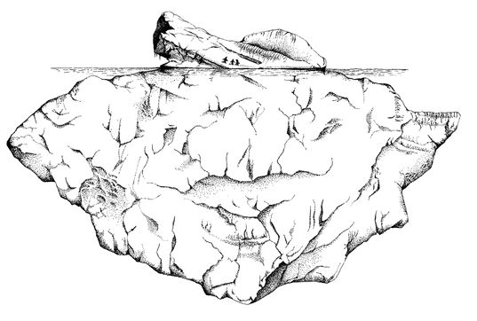
An iceberg afloat, with the “tip” above water
and the “root” below the surface
Another fascinating property of ice is its propensity to flow downhill as a glacier. The ability to flow is something we generally think of as a property of fluids, and thus we are led into a seeming paradox: A flowing solid? The resolution of this paradox lies in the fact that most solids, when they are close to their melting temperature, lose their rigidity and become soft. A stick of butter just out of the refrigerator is stiff and brittle, but that same stick left on the kitchen table will warm and become soft and ductile, even though still solid. Similarly, a candle is stiff, except near the flame, where it softens considerably. So, too, with ice—even though ice seems very cold to the touch, in reality it is very close to its melting point of 32º Fahrenheit, and so weak and ductile that, given sufficient time, it will spill off hills and plateaus and flow downhill like a river, even in its solid state.
Weakness in solids is not related only to temperature—it is also a question of time. Silly Putty, that favorite pink claylike material that delights children and adults, exhibits different behaviors depending on how fast it is stressed. It will snap like a twig if yanked apart, and bounce like a rubber ball if dropped. But it can be shaped like modeling clay if kneaded slowly. Similarly, rocks that will flake or fracture when hit with a hammer will bend and flow in response to steady geological forces applied over millions of years. The Appalachian Mountains in the eastern United States appear as a wide zone of valleys and ridges—giant wrinkles in Earth’s rocky crust that formed in the slowly closing vise of a collision between Africa and North America.
Ice does not really need a hill to flow down—it can spread sideways under its own weight. As snow accumulates in a region, the older snow is slowly compressed by the weight of the newer snow above it, and eventually the pressure recrystallizes the snow into ice. When enough ice accumulates and reaches a critical thickness, it will begin to squeeze the deeper ice outward, much like what happens when pancake batter is poured onto a griddle. Even though the batter is poured in the center of the griddle, it doesn’t stay there—it spreads radially outward into a sheet, eventually to cook into a pancake. So it is with ice on Earth; thick accumulations of ice spread outward to form a continental-scale ice sheet thousands of miles across but only a mile or two thick.
The spread of ice over the continents during an ice age and the flow of ice from mountains downward toward the sea have profoundly shaped the landscape of Earth. Like a massive bulldozer, flowing ice erodes and transports the material over which it moves; soil, rock, and vegetation all yield easily to its force. The beautiful deep fjords incised into the coasts of Norway, Alaska, Chile, and New Zealand are all products of severe glacial erosion, an aesthetic inheritance from the recent ice ages. And when glacial ice eventually melts, the debris of glaciation is simply dropped in place, forming a blanket of glacial deposits that becomes yet another layer recording a dramatic episode in Earth’s history. Some of these deposits, rich in organic matter, comprise today’s bountiful soils that yield food for the people of the world.
Another important property of ice is its reflectivity. Everyone who participates in outdoor recreation in the winter—skiers, skaters, hikers, snowmobilers—knows or painfully learns the perils of sunburn from sunlight reflected upward from snow and ice. All the surfaces that make up the face of the Earth—the soils, the rocks, the vegetation, the oceans, and the ice reflect some sunlight back to space, but none does a better job than snow and ice. The property of a surface that expresses how much incoming sunlight is reflected away is called its albedo, the Latin word for whiteness. A surface with an albedo of 25 percent means that one quarter of the light that falls on that surface is reflected back to space. Not surprisingly, surfaces such as black rocks, rich dark topsoil, and dark green vegetation reflect much less sunlight, and accordingly have smaller albedos—they are not very “white.”
The reflectivity of ice, particularly as compared with water, has played an interesting role in navigating through polar waters. On the fringes of both the Arctic and Southern oceans, the breakup of sea ice in the spring and summer produces areas of sea ice and of open water. The challenge facing a navigator aboard a ship is to find the passages of open water between the sheets of sea ice. That is where knowledge of albedos can be a big help.
White sea ice is a much better reflector of sunlight than dark seawater or ice-free land. When there are clouds overhead, the more abundant light reflected from the ice illuminates the base of the clouds with diffuse light, much like the nighttime lights of a city cast a glow in the sky that can be seen many miles away. To the polar navigator, the bright regions of distant clouds signify ice below, and the darker regions signify open water. Early navigators had a phrase for this: “watch the clouds to find the water.” This phenomenon is colloquially termed “ice blink” or “water sky,” and it is referred to frequently in the navigational logs and diaries of polar explorers. It is a phenomenon equally well known in the cultures of the Arctic’s native peoples.
As Captain Cook sailed beyond 71º south in January of 1774, his farthest point south in all of his three voyages of discovery, he knew from ice blink that he was close to the ice margin, well before he actually saw the ice:
We perceived the clouds over the horizon to the south to be of an unusual snow white brightness, which we knew announced our approach to field ice … the southern half of our horizon was illuminated by the rays of light which were reflected from the ice to a considerable height.17
On a much larger scale, the high albedos of ice and snow influence Earth’s climate substantially, because the polar ice caps reflect away much of the sunlight that illuminates the high latitudes. With the rapid summertime loss of Arctic Ocean sea ice that is now taking place, the albedo of the Arctic Ocean is also changing. The balance between white ice and dark ocean water is tilting toward darkness, and the albedo is gradually falling, leading to less sunshine being reflected away and more being absorbed. In climate terms, this imbalance means the Arctic is becoming warmer because it is retaining more solar energy.
Ice interacts with light in ways other than simple reflection. Reflected light usually looks much the same as incoming light. The act of reflection plays no favorites in terms of colors—there is no selective enhancement of any of the colors that make up visible sunlight. But this is not the case for the light that is transmitted through the ice. The molecular bonding in the H2O molecule, the crystalline structure of ice, and impurities such as tiny bubbles, together act like a filter, removing the red and yellow end of the visible spectrum but letting the blues pass through relatively unimpeded, thus giving extraordinary shades of blue to deep snow and glacial ice.

NATURALLY OCCURRING ICE is widespread on Earth, but it is not found everywhere. In fact, as ubiquitous and familiar as ice may seem, there are places in the world where ice once was, and perhaps still is, a curious and unfamiliar material. In One Hundred Years of Solitude, set in his native Colombia, Gabriel García Márquez describes such an encounter:
… there was a giant with a hairy torso and a shaved head, with a copper ring in his nose and heavy iron chain on his ankle, watching over a pirate chest. When it was opened by the giant, the chest gave off a glacial exhalation. Inside there was only an enormous, transparent block with infinite internal needles in which the light of the sunset was broken up into colored stars… . José Arcadio Buendía ventured a murmur:
“It’s the largest diamond in the world.”
“No,” the gypsy countered. “It’s ice.”
José Arcadio Buendía, without understanding, stretched out his hand toward the cake, but the giant moved it away. “Five reales more to touch it,” he said.
José Arcadio Buendía paid them and put his hand on the ice and held it there for several minutes as his heart filled with fear and jubilation at the contact with the mystery … with his hand on the cake, as if giving testimony on the holy scriptures, he exclaimed: “This is the great invention of our time.”18
Where on Earth does ice occur naturally? The simple answer: wherever there is water available to freeze and it is cold enough to freeze it. Let’s have a look first at what controls Earth’s temperature at different locations. Over the surface of our planet there is a wide variation in temperature related to the angle at which the Sun’s rays strike Earth. At the equator, the rays are nearly perpendicular to the surface, and near the poles they just graze the surface. Effectively that means that the farther away one is from the equator, the less solar heat is available for warm-ing the planetary surface. This establishes a general pattern of gradually diminishing temperature toward the poles—with the poles averaging (on an annual basis) about 90 Fahrenheit degrees colder than equatorial regions, or a drop of roughly 1 Fahrenheit degree for every 70 miles one travels away from the equator toward the poles. It should be no surprise that the poles are the principal domains of ice on Earth, both on the continent of Antarctica and over the Arctic Ocean and Greenland.
There is also a very noticeable decrease in temperature as one goes up into the atmosphere, much more so than heading toward either pole. Over the entire distance from equator to pole, about 6,250 miles, the temperature drops by about 90 Fahrenheit degrees, but that drop in temperature can be experienced also by going only five miles up into the atmosphere. When the pilot of a passenger aircraft announces that the plane has reached its cruising altitude of 35,000 feet and the outside air temperature is -55º Fahrenheit, that frigid temperature is the result of the airplane’s climbing up into the atmosphere.
Ice also forms in the atmosphere when water vapor is carried sufficiently far upward, giving rise to snow during winter months and occasional hail during severe summer storms. Hail usually falls in the form of spherules, ranging from pebble to baseball size, and has the potential to be both damaging and dangerous. It can flatten crops in a matter of minutes, leave cars with a pitted complexion, and injure people and animals unable to find shelter.
Some tiny ice crystals also form high in the frigid polar stratosphere, where they provide catalytic surfaces for separating chlorine from man-made chlorofluorocarbons, the CFCs that revolutionized the refrigerator industry. The freed chlorine in turn destroys stratospheric ozone each spring, thus opening the seasonal ozone hole over Antarctica. The consequence of this ozone depletion is increased ultraviolet radiation reaching Earth’s surface, with attendant radiation damage to the biosphere. Humans in particular are vulnerable to skin cancers, cataracts, and immune system impairment.
Temperature also changes going down from the surface, into the rocks of Earth’s crust. But in the downward direction, the temperature goes up, an indication that the interior of Earth is losing heat to the surface. The rate at which the temperature increases downward is about five times the rate that it cools upward in the atmosphere. Five miles up in the atmosphere it is 90 Fahrenheit degrees cooler, but at a depth of only one mile below the surface, it is 90 Fahrenheit degrees warmer than at the surface. That is the reason that chilled air must be pumped into deep mines, to make it possible for miners to work. At much greater depths the temperature in places reaches the melting point of rock and produces volcanic magma.
But in the polar latitudes, where the average surface temperature on land is well below the freezing point over long periods of time, water in the subsurface will freeze despite the fact that the temperature increases with depth. This freezing gives rise to perennially frozen ground known as permafrost. Eventually, of course, one reaches a depth where heat coming from Earth’s deeper interior has warmed the rocks enough to prevent permafrost from forming. That depth defines the lower margin of permafrost. Permafrost has been observed to almost a mile below the surface in northern Siberia, but in areas where the average annual temperature is only slightly below freezing, the permafrost is much thinner. About one fifth of Earth’s land area, mostly in the northern reaches of Asia, North America, and Europe, is characterized by permafrost today.
Ice also forms in sediment beneath the seafloor, in a crystal structure that is in the shape of a not-quite-spherical cage. The depth at which this form of ice occurs is relatively shallow, some five hundred feet or so below the seafloor, within the sedimentary deposits. This particular type of ice is widespread on the continental shelves and, on rare occasions, in deep lakes on the continents, such as in Siberia’s Lake Baikal. What makes this ocean floor ice of special interest is its ability to trap methane—natural gas—inside the molecular cage. Drilling into the shelf sediments has retrieved samples of this gas-bearing ice from a great many sites around the world. When ignited, the samples put on quite a show—to see chunks of ice aflame is completely intuition-defying. Methane, of course, is an important source of energy in the industrialized world, but it is also a potent greenhouse gas when it resides in the atmosphere. The release of methane from its icy subsurface cage is therefore a worry in the context of climate change.
We typically think of water becoming ice in terms of temperature alone, but pressure also plays a role. The pressure under which ice forms at the surface of Earth is more or less uniform—it is the pressure caused by the weight of the atmosphere lying above the surface. Informally, this amount of pressure has been called “one atmosphere” or “one bar.” Under this amount of pressure, freshwater will freeze when the temperature drops below 32º Fahrenheit.
Even the pressure of the atmosphere is somewhat variable at Earth’s surface. In the eye of a hurricane the atmospheric pressure is lower than average, and on a cold, clear, sunny winter day the pressure is above average. Even though this variability of pressure from place to place is small—typically only a few percent from the average—the highs and lows play a big role in the pattern of atmospheric circulation and our daily weather.
Bigger changes in pressure occur with a change in elevation. Along with the temperature in the atmosphere, as one goes up, the pressure goes down. At sea level, the entire atmosphere is above you, but at the top of Mount Everest, only about half the mass of the atmosphere presses on you, exerting only a half atmosphere of pressure. But even at elevations far below the summit of Mount Everest, the thinning of the atmosphere becomes apparent—where there is less atmosphere, there is less oxygen to breathe, and even simple tasks become arduous. And when the atmospheric pressure is less, water boils at a lower temperature, thus requiring longer to cook rehydrated meals and making water purification less reliable—facts that every experienced mountain camper knows well. Lower atmospheric pressure also shifts the freezing temperature of water very slightly upward.
Let us pause to reflect on what a very special thermal environment the Earth’s surface provides us, sandwiched between extreme heat downward and ice upward, in just a few miles in either direction. Other life-forms, mostly microbes, can eke out an existence in these extreme thermal environments, but we humans, pansies in terms of our preferred temperature, stick pretty close to sea level. Our comfort zone is a very thin envelope of oxygen-rich atmosphere just above Earth’s surface—a Goldilocks environment where it is not too hot and not too cold. When we turn to look at the possibilities of life elsewhere in the solar system later in this chapter, we will see that Earth itself is sometimes called the Goldilocks planet, but for a different reason.
ASIDE FROM TEMPERATURE, the other part of the recipe for ice is the availability of water. H2O takes up residence in many places on Earth, in places appropriately called reservoirs. The principal reservoirs are the oceans, the polar ice sheets, lakes and rivers, underground water, the atmosphere, and the biosphere. H2O moves from one reservoir to another by evaporation, precipitation, biological transpiration, and the downhill flow of water and ice. Of the reservoirs, clearly the worldwide ocean is the largest by far, holding almost 96 percent of Earth’s H2O. After the oceans, the next biggest reservoir is ice, with a little more than 3 percent of the global H2O. That leaves only 1 percent for everything else—all of the surface, subsurface, atmospheric, and biologic water combined. The volume of water in lakes, rivers, groundwater, atmospheric water vapor, and vegetation is small compared to that in ice, and very small compared to the volume of ocean water.
On land, the presence or absence of water depends strongly on the transport of water vapor from the sea to the land by atmospheric circulation. In some places—Earth’s deserts—the atmosphere delivers almost no water. Other areas receive abundant rain and snow, and have become places of human settlement and agriculture, and tropical, temperate, and boreal forests. At low elevations outside the polar regions, the precipitation yields wetlands, lakes, and rivers, some of which experience seasonal freezing, and at higher elevations, the precipitation produces snowpack and glacial ice. In the polar regions, snow and ice dominate at every elevation.
SEA ICE
In the oceans one need not search for water—it is very apparent and readily available for freezing when the temperature is sufficiently cold. As one gets closer to the poles, the temperature at sea level approaches the freezing mark, and the ocean water itself will freeze into sea ice. Seawater, because of its salt content, freezes at a slightly lower temperature (28.8º Fahrenheit) than freshwater. Annual sea ice—ice that forms and breaks up each year at high latitudes—is about three feet thick. The Antarctic continent effectively doubles in area—to a size exceeded only by Asia and Africa—as the bordering Southern Ocean freezes each winter.
Watching the sea freeze over is an eerie experience. It begins rather innocuously with the formation of small pancakes of ice that grow laterally until they meet other pancakes. At the common boundaries, small ridges form and intersect to form an array of polygons, a geometric tiling of the ocean surface that forms a semi-rigid mat extending as far as the eye can see. Under continued cold conditions the ice pancakes thicken, and in the process of freezing, the salt is expelled from the solidifying ice. It forms dense plumes of brine that sink from the base of the newly forming ice and descend all the way to the bottom of the ocean. And all of this happens rather quickly. An inexperienced captain can discover that in just a short time his vessel has lost the freedom of the open sea and is incarcerated by the tight grip of ice. A great fear of early sea captains exploring in the Arctic and Antarctic was the possibility of being trapped by a rapid freezing of the sea, and forced to winter over, cold and hungry, until the ice broke up the following spring.
Such concerns about sea ice figured prominently in the exploration of the Bering Strait, that narrow strip of ocean that separates Asia from Alaska. Vitus Bering, a Danish sea captain in the employ of Czar Peter the Great of Russia, was given the assignment to determine whether Asia was connected to North America. We know today that the two continents are not connected, but early in the eighteenth century, that fact of geography was still uncertain. The plan to determine the existence of a strait was straightforward: along the Arctic coast in the far east of Russia, there was a small trading post where the Kolyma River emptied into the Arctic Ocean. If one could reach this trading post by sea from the Pacific Ocean, it would prove that there was open water between Asia and North America.
Traveling close to the coast of Russia in mid-August of 1728, Bering actually sailed from the Pacific into the Arctic Ocean, but he was not certain that his course had taken him through a narrow strait because he could not see North America to the east. Bering continued north, but even in late summer the sea was showing signs of an imminent freeze. He decided not to turn west, toward the mouth of the Kolyma River, for fear of being trapped in the ice for the winter months. Bering ordered a course reversal, and the ship returned to the Pacific.
Even though never sighting North America and never reaching the Kolyma River—the position of proof—Bering felt he had gone far enough to demonstrate the existence of a strait between Asia and North America. When he returned to St. Petersburg, however, the armchair geographers felt otherwise. They criticized his judgment in choosing safety over mission, denied him a promotion, and shamed him into a second voyage. On that voyage, a shipwreck forced him to make winter camp on a remote treeless island at the very end of the Aleutian Islands arc. He and many of his crew perished over the winter; come spring, the few survivors salvaged timber from the wrecked ship, built a new, smaller ship, and sailed away to tell the tale.
SEA ICE ON THE MOVE
Near the end of the nineteenth century, many of the geographic “targets” of explorers—the source of the Nile, the Khyber Pass, Timbuktu—had been reached. But the poles of Earth, both North and South, remained unconquered. The movement of the Arctic sea ice figured prominently in Norwegian explorer Fridtjof Nansen’s attempt to be the first to reach the North Pole. Nansen, already well known for his first-ever crossing of Greenland on skis in 1888, had a clever idea of how to reach the North Pole with a minimum of effort. Because Arctic sea ice is always on the move, drifting generally from Siberia toward Scandinavia and Greenland, Nansen would let his ship become frozen into the ice in the far east of the Arctic Ocean, and simply drift with the moving sea ice on its way toward Greenland and its ultimate breakup and escape into the North Atlantic. If one understood the dynamics of the drift well enough, and entered the ice at the proper location, the drifting sea ice, moving at around three to four miles per day, would carry the ship over the pole—a leisurely cruise, so to speak, without an epic struggle against nature, a triumph of cleverness over brute strength.
Nansen’s ship Fram (“forward” in Norwegian) had been designed for such a voyage, incorporating a rounded hull that would enable the ship to be lifted upward by the pressures within and between sheets of drifting sea ice, rather than risk being crushed with a sharper, more conventional hull architecture. Nansen estimated that, once drifting with the ice, the ship would reach the pole in about a year and a half, and continue on to Norway in perhaps a similar amount of time. In two to three years the North Pole would be his, and the world would know it.
The devil, of course, was in the details—finding the right spot to enter the ice, so that the drift trajectory would carry the ship to the pole. He would have only one chance to get it right—once the Fram was locked into the ice there would be no opportunities for course corrections. 19 Nansen chose to enter the ice near the New Siberian Islands, a little east of the mouth of Russia’s Lena River. The entry was in late September 1893, just at the onset of the Arctic winter.
Unfortunately, his entry point was not quite right. By the end of 1894, after more than a year of drifting, it was clear from astronomical observations that the ship would not pass over the pole. In fact, there was little chance it would even get beyond 85º north, some 350 miles from the pole. With the possibility of the ship achieving the pole already lost, the thought of spending yet another year or even two aboard the ice-locked drifting Fram before she was released to the sea was too painful for Nansen to consider.
Not one to give up the polar quest easily, he decided to leave the ship in the care of his crew and, with a single companion, Fredrik Hjalmar Johansen, set off across the ice with dogs, skis, a sledge, and kayaks, in an attempt to reach the pole. Nansen and Johansen left Fram in late February of 1895 and seemingly were making good progress, but by early April, observations of the position of the Sun showed that the pole was still 250 miles away. Six weeks of hard travel on the ice had brought them only 100 miles closer to their goal. An awful realization hit them: as they were struggling north, the ice was drifting south, erasing some of their daily progress toward the pole. On April 8, they recognized the futility of the attempt, and turned around.
Nansen and Johansen knew they would have little chance of finding Fram, because in the six weeks that had elapsed since they left the ship, she had continued to drift with the ice. They would have to make the homebound journey back to Norway, a distance of some 1,400 miles over the Arctic ice, entirely on their own. After many more months of adventure, hardship, and an improbable encounter with another polar adventurer, Nansen and Johansen set foot on Norwegian land in mid-August of 1896. Meanwhile, Fram had continued her long and slow drift across the Arctic Ocean, to break out of the ice on the very day that Nansen and Johansen reached Norway. Within a week the entire expedition had been reunited.
The drifting of sea ice also figured dramatically in the saga of Ernest Shackleton’s Imperial Trans Antarctic Expedition of 1914-16. Shackleton had already participated in two unsuccessful attempts to reach the South Pole, the Discovery expedition led by Robert Falcon Scott, in 1901-3, and the Nimrod expedition under his own leadership, in 1907-9. The first fell short by 530 miles; the second reached 88º23’ south, only 97 miles from the pole. The overland segments of both expeditions turned back shy of the polar goal because of deteriorating health, diminishing provisions, and concerns that if they pressed ahead they might perish.
In 1911, Robert Falcon Scott and Roald Amundsen mounted rival expeditions to reach the South Pole. The ship that brought Amundsen to Antarctica was none other than Fram, the one Fridtjof Nansen had used in his unsuccessful attempt to drift over the North Pole. Amundsen and Scott chose different pathways to the pole, with Scott’s slightly longer but better known. The race to the pole was won by Amundsen, by more than a month; his small team reached 90º south on December 11, 1911. Scott arrived at the pole thirty-five days later, only to endure the great disappointment of seeing the Norwegian flag atop a small tent left by Amundsen. But that disappointment was eclipsed by the death of Scott and the other four in his polar party during their return from the pole.
With the attainment of the South Pole then in Amundsen’s book of laurels, and Scott’s as well posthumously, Shackleton was forced to envision a different kind of exploration, a bold expedition that he hoped would ensure his own lasting prominence in Antarctic exploration. He devised a plan to cross the entire Antarctic continent, on a route from the Weddell Sea to the Ross Sea, with a stopover at the South Pole as a midway point. This expedition was to become known as the Imperial Trans-Antarctic Expedition, and the ship that carried Shackleton into the Weddell Sea was the Endurance.
Just as Fram did intentionally in the Arctic, Endurance did unintentionally in the Antarctic—it became locked in the ice of the Weddell Sea in January of 1915, and began a slow clockwise drift, following the current gyre in the sea beneath. The drift carried Endurance within some sixty miles of the ice shelf at the southern margin of the Weddell Sea, where Shackleton had planned to disembark and begin the overland trans-Antarctic trek. But the ice took them no closer—in fact, it began to carry them slowly away from the southern coast of the Weddell Sea and toward the long finger of the Antarctic Peninsula. By April, the drift exceeded two miles per day to the northwest, and the possibility of launching the overland segment of the expedition was rapidly receding. As author Alfred Lansing writes, “Endurance was one microscopic speck … embedded in nearly one million square miles of ice that was slowly being rotated by the irresistible clockwise sweep of the winds and currents of the Weddell Sea.”20
Fram and Endurance had both been built by Norwegian shipwrights for service in polar regions. But Fram was designed specifically for a long sea ice drift—her rounded hull would accommodate horizontal pressure from the ice by popping upward as the ice closed in around it. Endurance was built very sturdily to push ice around, but her less rounded hull did not fare well when surrounded and squeezed by ice. Before she could be released from the ice as she moved northward toward a latitude (and season) of sea ice breakup, the ice crushed her, and she sank—Endurance did not endure the harshness of sea ice entrapment. The survival of Shackleton and his entire crew after the loss of Endurance is one of the moving stories of polar exploration and rescue.
ICE, WATER, AND LIFE
Water is considered an essential ingredient of life as we know it. The human body is approximately 90 percent water, so we are mostly hydrogen and oxygen. Add a little carbon and nitrogen, and you have the materials for 96 percent of our mass. Earth occupies a special location in the solar system because it is the only place in the neighborhood that has abundant liquid H2O, that essential ingredient for life, at its surface. For this reason it is sometimes called the “Goldilocks planet”—not too close to the Sun to lose all its water, not too far to have only ice. The third rock from the Sun is just about the right temperature for the purpose of life.
But Earth almost did not qualify for hosting water at its surface. Although the amount of radiant energy the Sun delivers to Earth is adequate to make our planet hospitable to liquid H2O, Earth reflects about 30 percent of that energy back into space, thereby rejecting a sizable fraction of the solar gift of warmth. But Earth’s climate system has another important player—an atmosphere that compensates for the reflective loss. The atmosphere is 99 percent nitrogen and oxygen, but the remaining 1 percent includes very small amounts of water vapor, carbon dioxide, and methane—heat-trapping gases that block heat trying to escape from Earth in the form of long-wavelength infrared radiation. This blanketing is called the natural greenhouse effect, as opposed to the contemporary warming of the planet due to anthropogenic greenhouse gases—those of human origin—now being added to the atmosphere through the burning of fossil fuels.
The natural greenhouse effect is a characteristic of Earth’s atmosphere that has been around since Earth’s earliest days as a planet, whereas the anthropogenic greenhouse effect is a phenomenon of just the last few centuries of Earth history. We should be very grateful for the natural greenhouse effect, because Earth is some sixty Fahrenheit degrees warmer than it would be without it. It has made Earth the water planet, the blue planet, instead of just another white snowball in orbit around the Sun.
IS EARTH UNIQUE in the solar system as a place where life has emerged? The elements that comprise life and the rocks of our planetary host—hydrogen, oxygen, carbon, nitrogen, iron, magnesium, and silicon—are among the ten most abundant elements in the entire universe. It is clear that nature uses the most common raw materials around for both planetary architecture and life. With such materials widely available, might there be other places hospitable to life?
Of the other planets in the solar system family, Mercury and Venus are too close to the Sun to retain water, let alone to enable ice to form. But farther out in the solar system ice abounds, giving rise to fascinating possibilities of life, provided energy is available to change ice to water. Mars displays very obvious ice caps in its polar regions, two little white skullcaps sitting on the red planet. The northern cap is much larger than the southern, with a diameter some three times greater. But there is a second asymmetry that is more amazing—the two polar caps reveal a different composition, at least at their respective surfaces.
The surface of the southern cap of Mars is made up of solid carbon dioxide (CO2), which we call “dry ice,” because when it warms, the solid transforms directly into a vapor, without first passing through the liquid stage that characterizes the behavior of H2O on Earth. Thus on Mars the transformation of solid CO2 is a “dry” one, to a vapor, whereas the conversion of solid H2O on Earth is a “wet” one, to a liquid, water. It is perhaps no surprise that Mars’s south polar cap shows a surface composition of carbon dioxide—CO2 is the principal component of the Martian atmosphere, and the south polar temperatures are sufficiently cold to allow solid CO2 to condense out of the atmosphere onto the surface.
The big surprise is that the surface of the larger northern cap is not CO2, but instead solid H2O, the ice that we know and love on Earth. The atmosphere of Mars is much thinner than Earth’s, and exerts less than 1 percent of the pressure of Earth’s atmosphere. At such a low pressure, H2O can also change from solid to vapor directly, a “dry” transformation, which can be seen indirectly as a summertime increase of water vapor over the north polar cap.
Both of the Martian polar caps probably contain substantial H2O ice, but the H2O in the southern cap is likely deep beneath the CO2 ice. The reason for this compositional asymmetry is not well established, but may be related to a north pole that is warmer than the south pole, because of the presence of more summertime dust on the north polar surface, which absorbs more sunshine.
The surface of Mars away from the poles, despite having a very low atmospheric pressure on it and a temperature well below freezing today, shows many well-developed river channels that indicate that water once flowed over the surface. Layers of sedimentary rock, typically formed as deposits in lakes, rivers, and oceans on Earth, can be seen in the Martian landscape. And there is reason to suspect that some of the water that once flowed on Mars may still be there, in the form of ice just beneath the Martian surface and possibly in liquid form at greater depths. Ground-penetrating radar surveys conducted in 2008 from the Mars Reconnaissance Orbiter spacecraft returned signals indicative of massive ice deposits in the southern mid-latitudes of Mars, suggesting that there may be large glaciers buried beneath just a few feet of dust and rock debris.21 With so much ice on Mars, the presence of water and life on the red planet is an intriguing possibility.
A TRIP TO MARS
In August of 2007, I had the special experience of watching the launch of a spacecraft to Mars called the Phoenix Mars Lander. On launch day at Cape Canaveral I arose well before dawn and made my way to a viewing site, on the beach a short distance from the launchpad. The tense countdown proceeded flawlessly, right to the moment of ignition. It was a thrill to see the main rocket engines ignite and roar, and, a few seconds later, to watch this huge taxi lift its small spacecraft passenger into the atmosphere, accelerate to a velocity sufficient to escape Earth’s gravity, and send it on a nine-month journey to Mars. Although Mars’s orbit is only 50 million miles beyond Earth’s orbit, a distance half again as far as Earth is from the Sun, the actual journey of the Phoenix Lander covered 422 million miles, as the spacecraft had to chase Mars in its orbit, a veritable moving target.
The instruments aboard the Lander were designed to send back information about the atmosphere and soil of Mars, and in particular to seek evidence that might confirm the presence of some form of microbial life, if indeed any were present. To be sure the instruments would perform as designed, they were tested in the frigid desert environment in the Dry Valleys of Antarctica, a short helicopter ride from McMurdo Station, a U.S. base in the Ross Sea sector of the Antarctic. This cold, dry, windy setting is probably very close to the actual operating conditions on Mars.
The Phoenix spacecraft arrived at Mars in late May of 2008, and after a breathtaking descent through the thin Martian atmosphere, landed safely at the target landing site close to the north polar cap. I am always amazed at the precision of such operations—a NASA engineer likened it to a rocket launched in California successfully reaching its distant target—home plate in Chicago’s Wrigley Field! I “watched” the landing, too, so to speak, over NASA TV’s live Internet broadcast. It was an emotional moment, tying together both ends of this 269-day journey across the vastness of the solar system. Phoenix, never distracted from duty, announced its own arrival, waited a few minutes for the dust to settle, unfolded its solar panels to power its instruments, and, like an enthusiastic tourist, began taking pictures to send home.
The first snapshots showed “patterned ground,” almost identical to earthly terrains in Siberia, Alaska, and northern Canada—low ridges of rock fragments squeezed upward into polygonal patterns by cycles of freezing and thawing. Soon Phoenix deployed its soil scooper, and brought into its mini-laboratory some Martian soil containing white nuggets, later confirmed to be H2O ice. The soil also contained hints of calcium carbonate, the principal mineral of limestone, which on Earth is usually precipitated in water. Also in the soil were traces of perchlorate, an oxidizing agent that could provide nourishment for any microbial life that might be present.
But Phoenix’s main instrument, the one designed to detect organic compounds, proved balky, and only about half the experiments on the schedule were able to be conducted. Even though Phoenix continued to operate well beyond its design lifetime of three months, providing photos of dust storms and the distant faint Sun, there was no confirmed detection of an organic molecule. Of course, absence of evidence is not the same as evidence of absence, and so the possibility of some form of life on Mars remains. At the end of October of 2008, as the Sun reached the horizon, Phoenix’s solar panels no longer could gather enough light to power the Lander, and by mid-November it had fallen totally silent. There is little likelihood it will survive the freezing darkness of the Martian winter.
ICE (AND LIFE?) BEYOND MARS
In the more distant and frigid reaches of the solar system are the planets Jupiter, Saturn, Uranus, and Neptune—very large bodies mostly of gaseous hydrogen and helium without a solid surface of ice or rock anywhere close to their visible cloud tops. The temperature of Jupiter’s cloud tops is around -250º Fahrenheit, and it only gets colder farther out. These giant planets have many small satellites orbiting about them, made up mostly of rock and ice, in varying proportions and vertically segregated—a rocky interior covered by a shell of ice hundreds of miles thick. Just as Earth’s rocky crust displays faults and folds and ancient granite intrusions as evidence of a long geologic and tectonic history, so also can features in the icy crust of these distant satellites provide an archive of the processes that shaped them over time. Some of these processes may have melted ice to form water and provide an environ ment conducive to life.
Early in the history of the solar system there was a lot of debris flying around and colliding, creating heavily cratered surfaces such as we see on Earth’s moon. If nothing else ever happened to bodies such as the moon, their surfaces today should look much as they did three to four billion years ago—heavily cratered. But if other processes are active over geologic time, surfaces can undergo alteration and modification. On Earth the ancient cratered surface has been almost totally obliterated by the process of plate tectonics, which recycles most of Earth’s crust back into the planetary interior every two hundred million years or so. And what has not been recycled, what is left at the surface, is deeply eroded over time, or covered up by younger layers of sedimentary rock. In effect, Earth gets a periodic resurfacing, just as many roads—potholed and broken up during a harsh winter—receive a new layer of tarmac in the spring.
Many of the icy satellites around Jupiter and Saturn are indeed heavily cratered—the telltale signature of an ancient surface covering a dead interior. But other satellites display a very smooth surface with very few craters. Such a juvenile complexion, unblemished by the pockmarks of impacts, is an indication that the icy surfaces have experienced “resurfacing” events in their history.
How does an icy surface get rejuvenated? During a hockey game, the ice surface gets cut and scored by the players’ skate blades, but between the periods of play, the surface is restored by a Zamboni, which spreads a sheet of water over the degraded ice that quickly freezes into a new smooth playing surface. So what is the great Zamboni resurfacing machine that operates in the distant reaches of the solar system? Perhaps, surprisingly, it is water coming from the interior of these planetary satellites, water that derives from melting at the base of the thick surface layer of ice. But the source of the heat that melts the ice is one that is not so familiar to Earth-dwellers—the heat derives from tidal forces exerted on the small satellites by the giants in the neighborhood, the planets Jupiter and Saturn. The nature of this heat-generating mechanism is very interesting.
TIDAL HEATING
Many people are vaguely aware of tides, but don’t think much about them unless they live on the seacoast. Tides in the ocean—the rhythmic rise and fall and sloshing around of the sea—are due to interactions between the orbits and gravity fields of the Sun, moon, and Earth. What most people are unaware of is that the tidal forces move and distort not only the water on Earth, but also the solid rock of the planet, although not very much. The physics of tides tells us that the strength of the tidal force depends on the distance between the co-orbiting bodies and on how big they are. Tidal effects on Earth are small because the moon, although relatively close to Earth, is small—only 1/80 of Earth’s mass—and the Sun, although 332,000 times more massive than Earth, is more than 400 times more distant from Earth than is the moon. These same tidal interactions take place wherever planets have satellites orbiting nearby.
Orbiting closely around Jupiter are four natural satellites, each about the size of Earth’s moon. These satellites—called Io, Europa, Ganymede, and Callisto—are known as the Galilean satellites, because they were first sighted and described by Galileo in 1610. The tidal forces on these small bodies orbiting close to Jupiter are much greater than the tidal forces on Earth or the moon, because of the proximity and size of Jupiter, the largest planet in the solar system—the eight-hundred-pound gorilla of the neighborhood. These tidal forces distort and heat the interiors of the Galilean satellites, enough to melt rock on the closest, and to melt ice on the next.
The flexing and heating of these satellites by Jupiter can be envisioned in a simple experiment. Take a metal coat hanger, the kind that is shaped like a triangle with two sharply angled corners. Grasp the hanger by the long sides leading to one of the corners, and move the pieces apart and back together rapidly, thus flexing the corner. With only a few rapid flexes, the corner will get very hot to the touch. The energy that was expended in flexing the corner was converted to heat where the metal was being distorted. The tidal forces exerted by Jupiter on its nearby small satellites have the same effect on the satellite interior—the tidal energy is converted to heat.
Io is the closest to Jupiter, orbiting at a distance where the tidal heating is so intense that it melts rock. Volcanoes erupt at many places over its surface almost continuously. Europa is the next Galilean satellite of Jupiter, not as close to the giant planet as Io, but still close enough to show the effects of tidal flexing and heating. Europa displays much evidence of crustal resurfacing, particularly in the almost complete absence of craters on its smooth, icy surface. The water is not supplied externally, as with a Zamboni on an ice rink; it comes from a zone of melting ice far below the surface, and reaches the surface through major fissures and fractures in the icy crust. The outermost of the Galilean satellites is Callisto, beyond the reach of intense heating by Jupiter. Its icy surface displays the dense impact cratering of the early days of the solar system, with no evidence of a subsequent resurfacing that would indicate crustal melting and the presence of water.
Europa is a target in the search for extraterrestrial life, because of the likely existence of water in its interior.22 But could life develop deep within Europa, without benefit of the life-giving energy of the Sun? If Earth can serve as an example, the answer is certainly yes. At the bottom of Earth’s oceans, along the seams of the tectonic plates, bizarre but vibrant biologic communities have evolved in total darkness, energized completely by hot springs emanating from the oceanic crust. And on land, within caves near the surface, evolution has produced organisms without eyes, endowing them with other sensory organs that let them navigate their dark environment. NASA has already conceptualized a mission to Europa that envisions a robotic penetrator that could reach the zone of liquid water—but that might not even be necessary. If the resurfacing of Europa has used interior water, it may be that evidence of deeper life is sitting at the surface, frozen in the newer ice that has given Europa its smooth surface.
Saturn, the ringed planet beyond Jupiter, also has a host of satellites that display icy surfaces and are susceptible to tidal flexing and heating. One of these satellites, Enceladus, has recently revealed extraordinary features that hint at the possibility of primitive life getting a start in its interior. The unmanned Cassini spacecraft, operating in the vicinity of Saturn since 2005, has photographed large cracks in the ice near Enceladus’s south pole, and instruments aboard Cassini have detected evidence of active H2O venting from the cracks, in geyser-like features that also yielded carbon dioxide, nitrogen, and methane.23Even closer flybys of Enceladus, one at only fifteen miles above the surface, detected traces of other hydrocarbons such as acetylene, ethane, propane, benzene, and even formaldehyde. Clearly, the interior of Enceladus is an environment where organic molecules can form, and therefore it, too, may be a home to microbial life. Our solar system is proving to be far more diverse than ever imagined.
WATER AND LIFE BENEATH EARTH’S ICE
One need not travel to the far reaches of the solar system to seek life deep beneath ice. There are opportunities right here on Earth. The Antarctic ice blanket is on average about a mile and a half thick—at its thickest it is more than two and a half miles, about twelve Empire State Buildings stacked atop one another. And even though the surface temperature averages about -50º to -60º Fahrenheit over the year, at the base of this ice pile the temperature is warm enough to melt the ice. The heat comes from deeper within Earth, and although it is only a trickle of heat compared to what the Sun supplies, over time it has been enough to melt the base of the ice. Where does that meltwater go? Effectively, nowhere—it fills in low-lying topography in the rock surface to form what are called subglacial lakes.
Two and a half miles beneath the Russian Vostok scientific station sits the largest subglacial lake in Antarctica—Lake Vostok, about the size of Lake Ontario, and on average about a thousand feet deep. The ice beneath Vostok Station has been drilled and cored to a depth just a hundred or so feet above the lake surface, and at that depth the ice is about 450,000 years old.24 That means that if there is any life in the lake, it has been isolated from life elsewhere on Earth for nearly a half million years. Just as Australia, because of its long isolation as an island, has many animals unique to the territory—the kangaroo, the koala bear, the platypus—so might Lake Vostok show some microbial evolutionary products that reflect its long isolation.
This presents a very interesting experiment—drill through the last remaining ice to reach the lake, draw samples of the water to examine for life, and compare what is found to life forms in analogous settings elsewhere. But the challenge of this experiment is to ensure that no present-day life forms from the surface are introduced into the lake by the drilling process. Very careful thought has been given to how to achieve a clean entry, but full agreement is not yet at hand.
H2O ON THE MOVE
H2O on Earth is continually moving from one reservoir to another. Water evaporates from the oceans, and some of it falls as rain or snow on the continents. Some of the precipitation infiltrates the ground and moves slowly through the subsurface reservoir. Some flows overland in rivers, returning to the sea only a month or two after precipitation. Most snowfall lasts only a season on land before rejoining the ocean reservoir. But the snow that falls on the Antarctic ice cap, and is later compressed into a layer of ice, may remain on the great white continent for hundreds of thousands of years before it creeps back to the sea in one or another of the many glaciers that drain ice from Antarctica.
Over short intervals of time, there is an equilibrium between the relative sizes of the reservoirs, but over long periods of time, large transfers between the two biggest reservoirs, the oceans and ice, occur. When water leaves the oceans to become a temporary icy resident on the continents, the sea level falls, the continental shelves are exposed, and the continents experience an ice age. The spread of ice over the land surface overrides the grasses, plants, and trees, and eliminates the vegetable component of diet for a wide variety of omnivores and herbivores. When the climate ameliorates and ice sheets melt, the water returns to the oceans, the sea level rises, and the newly exposed land surface is reoccupied biologically. These temporary loans of ocean water to the continents in the form of ice have taken place some twenty times during the past three million years of Earth’s history alone, and several other times in the more distant past.
The fact that ice ages come and go tells us that ice on Earth is always on the cusp of existence—a push one way, and ice grows and spreads; a push the other way, and ice retreats and disappears. There is also a temporal component to the cusp with present-day relevance—on one side of the cusp are the ice ages of the recent past; and on the other side, the ascendancy of Earth’s human population as a major player in the global climate system, a force that is pushing ice toward disappearance. Today we are perilously poised on the peak of that cusp.