The 50 Greatest Walks of the World - Barry Stone (2016)
46. DINGLE WAY
County Kerry, Ireland
Distance: 162 km
Grade: Easy to Moderate
Time: 9 days
One of Ireland’s most popular long distance walking trails, the Dingle Way begins in the town of Tralee on the north side of the ‘neck’ of the Dingle Peninsula, the northernmost of County Kerry’s great finger-like projections into the Atlantic. A well-serviced trail, there’s never more than a few hours between towns, and there are some positively lonesome stretches of gorgeous, and surprisingly unpopulated, white sand beaches along the way.
Following the N86 out of Tralee the trail passes through Blennerville and crosses the Tralee Ship Canal before a series of backroads take you along the flanks below Slieve Mish, a lovely though compact and quite narrow mountain range full of U-shaped glacial valleys. A marshy section with red sandstone stepping stones leads you past the heads of several glacial valleys and an old reservoir that once provided Tralee with its drinking water. Look out for the Killelton Oratory, a relic of Irish monasticism, before crossing the Finglas River takes you on a descent into Camp village, and the beginning of your ‘loop’.
After leaving Camp the trail climbs to a saddle and parallels an impressive ridge between Moanlaur and Knockmore, before descending past the trail’s only real forest. After crossing the Emlagh River you will be rewarded with a wonderful view over Inch Beach where scenes from the 1960s film Ryan’s Daughter were filmed. A cafe here helps make for a welcome rest before a series of small roads past more glacial valleys takes you into the town of Annascaul, the birthplace of Antarctic explorer Tom Crean, whose home - from his retirement until his passing in 1938 - is now the South Pole Inn, a combination of museum and pub.
The trail then descends to sea level along a windswept hillside before passing by a roughly dressed sandstone three-storied tower house - all that remains of the mid-16th-century Minard Castle, made uninhabitable by the severe damage inflicted on it by Cromwellian forces in 1650. Narrow, unpaved and rural roads and secondary roads snake their way through farmlands to the west (don’t accidentally wander on to the Tom Crean Trail, a common error) and continue to Lispole with its breathtaking views of Croaghskearda (1,995 ft) and An Cnapan Mor (2,129 ft) before some often marshy farmland trails could see you slipping on your gaiters as you approach Dingle.
Leaving Dingle the trail runs along a beach for the first time at Ventry Harbour, and then the views really open up as you head off on a green road known as Bothar Dorcha (the Dark Road) around Mount Eagle, past Iron Age promontory forts and a multitude of beehive huts, and then get your first glimpses of the lovely Blasket Islands, inhabited until 1953 by an Irish-speaking population who lived in primitive cottages and whose language was the focus of several linguistic studies. Their descendants now live on the Dingle Peninsula, and it is possible to visit Great Blasket Island, the largest in the group, by ferry out of Dunquin Harbour which lies ahead of you - a fascinating side-trip worth factoring in to your itinerary. Out of Dunquin, grassy fields lead to picturesque Clogher Beach and then, after leaving Smerwick Harbour, you’ll follow a very impressive 6-km stretch of shore that doesn’t end until you reach Ballydavid. This is the centre of an area of uncommercialised local culture that remains uncrowded even during peak summer months when impromptu music sessions by local musicians can occur at any time. There is also a network of excellent local walks here including a section of the Saint’s Road and other trails to various archaeological sites.
Brandon Mountain is now looming as the Ballydavid cliffs obscure the ocean to your left, a fact that only serves to increase your focus on the challenge to come. The mountain, at 3,123 ft, is Ireland’s second highest and scaling it provides wonderful views back to the Three Sisters, a line of peaks that were the first landfall sighted by Charles Lindbergh at 10.52am on 21 May 1927 on his history-making transatlantic flight. Hiking Brandon Mountain, however, can be a real slog on the way up - a 2,000-ft ascent - particularly if the weather turns nasty, and can be downright dangerous on the way down, making the village of Brandon at the foot of the mountain on the shoreline of Brandon Bay seem a veritable oasis. Brandon is also a Gaeltacht village, meaning a place where the Irish language is the dominant vernacular.
DINGLE WAY
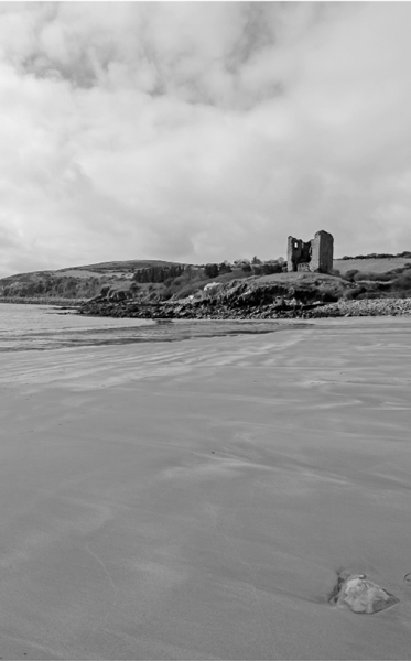
Photo: Jon Wright
From Brandon the trail leads to the village of Clogham on an undulating road inland before returning to the sea at Fermoyle, where it joins with the 14 km of Fermoyle Strand, Ireland’s longest beach, before following Scraggane Bay and on into the town of Castlegregory at the end of a small peninsula separating Brandon and Tralee Bays. From Castlegregory you negotiate a flat expanse of bogland before joining the main road into Camp, thus completing the Dingle ‘loop’, and from there you can follow the Tralee Ship Canal back to Tralee.
The Dingle Way is a coastal walk between sea and mountains. Farms are no-go areas, and where they occur walking is reduced to roads, beaches, or around the margins of heathlands. Mostly there is no right of way. But everywhere you go there is the backdrop of its gloriously glaciated interior mountains, and wherever you look there is colour: fuchsias, honeysuckle, bramble blossoms, emerald-green hills and deep-blue water. There are 4,000- year-old standing stones, ogham stones and beehive huts - more than 2,000 monuments at last count - set amidst an ever-changing light that illuminates this mountainous finger of land that has been home to human beings for more than 6,000 years.