The 50 Greatest Walks of the World - Barry Stone (2016)
18. HADRIAN’S WALL PATH
Tyne and Wear to Cumbria, England
Distance: 135 km
Grade: Easy
Time: 7 days
When Julius Caesar travelled to Britain in 55 and 54 BCE he wasn’t interested in conquest, instead simply initiating a period of looting and collecting of tributes, and perhaps gaining along the way a little prestige in the eyes of his conquered Gallic opponents. Caesar’s successor, the Emperor Augustus, showed little interest in occupying Britain after his advisors convinced him (mistakenly, it would turn out) it would require sending an entire legion there, and that its maintenance would be greater than could be collected in tributes and taxes. Claudius sent four legions to Britain in 43 CE, mined its lead and shipped its cereals over the channel to his army on the Rhine. By the time Publius Aelius Hadrianus was born in 76 CE, southern Britain was divided into local jurisdictions and was firmly under Rome’s control. Its far flung provinces in Wales and northern Britain were securely garrisoned, and a network of roads criss-crossed the British countryside, with watchtowers and forts at their junctions.
When Hadrian became Emperor in 117 CE incursions by Caledonian Picts into northern Britain were resulting in a continuing flow of casualties, and the north’s mountainous terrain was not providing comfort to the Roman cause. So in 122 CE Hadrian crossed the channel and went north to the River Tyne where he ordered construction of the Pons Aelius - a bridge and fort complex on the river. Itself a marvel of Roman engineering it would be the only bridge outside of Rome to carry the imperial epithet - a hint to its strategic importance. But Hadrian hadn’t come to Tyne just to inaugurate the building of a bridge. He envisaged a limestone wall, 4 m high and 3 m thick, made from locally quarried stone with rubble and mortar at its centre that would stretch across Britain from the banks of the River Tyne in the east to the Solway Firth on the Irish Sea (the section west from the River Irthing would originally have comprised turf, with stone added later). There would be milecastles (small forts garrisoning up to 60 men) at every Roman mile (a thousand paces made up of two steps, as marched by Roman armies), a series of sixteen forts with large gates facing north at points in the wall where roads passed through, plus turrets and crenellated parapets. Hadrian had given up on the idea of eastward expansion so beloved of his predecessor Trajan, dismantling the Roman bridge over the Danube and surrendering Roman gains in Mesopotamia, and had turned his gaze closer to home. Some eight years later his wall across Britain would be complete, a monument to the far flung limits of empire.
The wall - supplemented by a ditch on its north side, and the ‘vallum’, an earthwork on its southern side - was built not merely to deter invaders, but to help regulate the flow of people already under Roman rule and so maintain control of existing territories south of the wall. In a way, it was more a ‘fence’ than a defensive wall, and while the strategic priorities behind its construction might be the subject of some scholarly debate, what is certain is that while much of the wall is long gone, sections of Hadrian’s Wall have survived in somewhat spectacular style, no mean feat considering it stood idle for more than seven centuries after the Romans finally abandoned it. Over several centuries and as late as the early 20th century people were pillaging its stones to use in other buildings. The fact there’s still a wall to follow is due in no small part to Newcastle-upon-Tyne’s 19th-century town clerk and antiquarian John Clayton (1782-1890) who, in 1834, began buying up sections of the wall from Chesters all the way to the border with Cumbria (then Cumberland) to keep its stones from being removed. His enthusiasm was a major reason for the sections in and around Chesters, Housesteads and Vindolanda being in such excellent states of preservation today.
Ever since the trail’s ‘resurgence’ in the 19th century thoughts had been entertained that a path might be built to follow it. The 8th-century earthwork that gave rise to Offa’s Dyke Path in 1971, however, failed to give the impetus to its construction that some had hoped. In fact it wouldn’t be until 2003 that Britain’s fifteenth Long Distance Path was at last inaugurated, stretching for 135 km across northern England and for the most part closely following the ancient wall, the finest surviving example of frontier work in all of Rome’s classical period. There are just two segments where the path substantially deviates: roughly from milecastles 0-12 where it follows a river, and again through Carlisle following another riverbank. It can be a muddy slog at times, but the trail is well signposted and the walking straightforward and undemanding. There are six stages, beginning in the east with Wallsend to Heddon-on-the-Wall (24 km), then on to Chollerford (25 km), Steel Rigg (19 km), Walton (25 km), Carlisle (18 km), and Bowness-on-Solway (24 km).
But which way to walk? Scholars determined long ago that the wall was built ‘east to west’, but the savvy walker will be aware that the best direction to cross is from west to east, so that the prevailing winds will hit your back and not your face (also, the sun being behind you for the greater part of the day makes for much better photographs).
HADRIAN’S WALL PATH
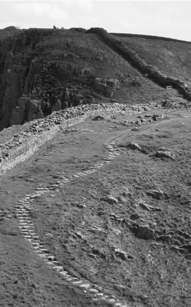
Photo: Johnnie Shannon
The wall itself can be divided into four states of preservation: Consolidated, where English Heritage have worked to consolidate it using mortar; Clayton, those sections repaired under the direction of John Clayton using the dry stone method with turf on top; Semi-field, genuine wall remnants in the form of small foundational sections or individual stones; and Rubble Rigg, linear mounds in situ where the masonry has been stolen. Archaeological sites are, of course, everywhere, and are reason enough to add a few days to any proposed itinerary. There is Segedunum, the wall’s most excavated fort that stood for 300 years and once housed 600 soldiers; Corbridge, a Roman town and supply base where you can walk on the very same road - the Stanegate - where Roman feet once trod; and Vindolanda Fort, which predated the wall and served as an important construction site, distributing supplies to the new wall. The site of the wall’s only ongoing archaeological dig, the wooden ‘writing tablets’ found at Vindolanda and dating to between 85 CE and 160 CE, which were unearthed by archaeologists while excavating a drainage ditch in 1972, are especially worth a look, giving as they do a rare glimpse into the sort of everyday conversations the Roman garrisons and their families had.
The Senhouse Roman Museum overlooking the Solway Firth, with its precious collection of military altars, funerary monuments, Celtic sculptures and Roman pottery is also a must-visit, as is Chesters Roman Fort in Northumberland, Britain’s most complete Roman cavalry fort with exceptionally well-preserved baths, steam room and officer’s quarters. There are also a number of English Heritage properties close to the trail, including Prudhoe Castle, Aydon Castle, Housesteads, Carlisle Castle, and the best-preserved of all Cumbrian monasteries - Lanercost Priory.
Be mindful, too, that when you come here you are walking over a fragile landscape. The greatest enemy of the wall has always been erosion, and foot traffic is increasing along the trail every year. Over 90 per cent of the original curtainwall has already been lost over time, not an ideal statistic, but the fact it hasn’t been horribly tampered with in a clumsy attempt to reconstruct it is a blessing. What makes walking the path so memorable is the sense that you are walking alongside a relic that is authentic and real. Pilfered, worn down, showing its age - yes it is all of this. But it is genuine.
Make sure that if you’re in a group you avoid walking in single file - spread your footsteps broadly so no one line of the path becomes excessively worn. Well-grassed paths provide cover and drainage for fragile earthworks below. And please, though it is tempting, resist the urge to walk on the wall itself. Although chamfered stones - those tell-tale shapes associated with crenellated walls - have been uncovered here, and there are steps present at Milecastle 48, suggesting soldiers may have in fact walked on top of the wall, there are no excuses for continuing the practice! And there are two full-height reconstructions of the wall - at Vindolanda and Wallsend - if one is keen to experience what walking on it was like.
The highest portions of the wall can be found 500 m east of Milecastle 42 at Thorny Doors, and at Hare Hill in Cumbria where a section became a part of a medieval structure before being rebuilt in the 19th century. Where the wall is gone altogether, the trail is well signposted to keep you on track. Fortunately, too, Ancient Rome is not the only point of interest here: the north bank of the Tyne, the wild escarpments of Whin Sill, the pastures of Cumbria, the salt marshes of the Solway Estuary, the path’s brief linking up with the Pennine Way - all this means there is also plenty of Great Britain herself - Provincia Britannia - to vie for your attention.