The 50 Greatest Walks of the World - Barry Stone (2016)
38. ANGLESEY COASTAL PATH
Anglesey Island, Wales
Distance: 212 km
Grade: Moderate
Time: 10-12 days
Don’t think that walking this trail, almost all of which is set within the boundaries of a designated Area of Outstanding Natural Beauty, is going to be a doddle just because it is classified ‘coastal’. Setting out from Holyhead you have an energy-sapping 13,695 ft of accumulated elevation gain in front of you, the product of a geologically complex coastline that has long been the focal point for countless field trips by schools, colleges, and university geology departments; a coastline that in 2009 led to the island being admitted to the European Geoparks Network, and then to the Global Geoparks Network the following year. If you’re the sort of person who can’t travel without a book tucked under your arm, a copy of Edward Greenly’s The Geology of Anglesey (1919) wouldn’t go amiss. Greenly was the first to coin the phrase Mona Complex, a term he applied to the Precambrian rocks that cover more than half of the island’s interior. His field work was so accurate that his two-volume work still remains a standard source of reference.
In fact you might want to build a few extra days into your itinerary just to allow for the geological wonders you’ll be passing on the way, and maybe even pick up a laminated ‘Geotrails’ map from the Geopark Visitor Centre in the Old Watch Tower at Porth Amlwch, so you’ll be better able to appreciate the tortured processes that went into creating Wales’s largest island.
Anglesey Island, it turns out, has some serious geological bragging rights: more than 100 rock types, four eras and a dozen Geological periods spanned, and more than 1.8 billion years of earth’s history on show. As a result there are a variety of ‘Geo Trails’, any or all of which are worth taking while you are there, trails such as the one on to Llanddwyn Island, a tidal island off Anglesey’s west coast connected to the island except at the highest of tides. Llanddwyn contains an entire plate tectonic record, including Precambrian pillow lavas that shine a light on the creation of the ocean floor. There are the spectacular folded schists (layers of crystalline, metamorphic rock) at South Stack lighthouse, the limestone coast around Penmon, a ‘thrust fault’ at Carmel Head, and the world’s premier ‘melange’ site (rocks jumbled together at the edge of a destructive plate margin) at Cemaes Bay. There are the Red Wharf Bay’s brachiopod-rich limestones formed long ago in warm tropical seas, and the rare blue schist at Llanfairpwll, turned blue under enormous pressure deep in the earth’s crust. All this and more threatens to significantly extend the journey of the well-informed walker.
The official starting point for the walk is outside the 16th-century St Cybi’s church in the centre of Holyhead on Holy Island. Walking a clockwise route you cross a low-lying path around the Alaw Estuary to Church Bay, after which you’re immediately immersed in one of the most remote areas on the entire trail, with rock-strewn coves merging with twisted, folded cliffs and the offshore islands at Ynys y Fydlyn. After the pretty village of Cemaes come the dizzying cliffs of Porth Llanlleiana and Porth Cynfor. Then comes quaint Amlwch Port and the sandy expanse of Dulas Estuary. Continuing down the east coast and passing through Moelfre, which didn’t receive its first street lights until after the Second World War, a series of dramatic limestone cliffs takes you down to Benllech and on to Red Wharf Bay. A serious stretch of shoreline walking follows before an ascent to the flat-topped limestone hill of Bwrdd Arthur (an old hill fort prior to and during the Roman invasion), then there’s more shoreline walking with views to the Cameddau Mountains and the Menai Strait.
The town Beaumaris at the eastern entrance to the Menai Strait, which can trace its origins to its development as a Viking port, is a must-do stopover if only to visit the ruins of magnificent Beaumaris Castle, begun in 1295 when Edward I ordered the construction of a moated castle as part of his campaign to conquer northern Wales. Even though work on the castle was abandoned after 1330 due to a lack of funds, and it was left incomplete with its south gate open to the sea to allow for resupply by ship, it remains one of Britain’s finest examples of symmetrical, concentric castle architecture. UNESCO went as far to describe it as an ‘artistic achievement’, lauding it for its ‘walls within walls’ design and the beauty of its proportions.
ANGLESEY COASTAL PATH
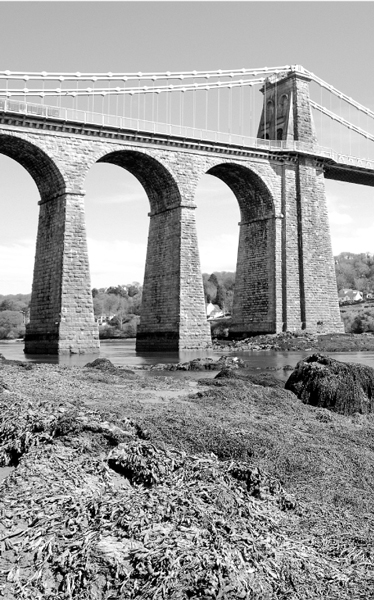
Photo: Ton 1959
Although the next section of the coastal path involves a lot of road walking, the trail from Beaumaris to Llanfairpwll has nice elevated views over the Menai Strait, plus it dips under the historic Menai Suspension Bridge. Designed by civil engineer Thomas Telford it was the world’s biggest suspension bridge when completed in 1826 and slashed travel time to London for farmers who no longer had to negotiate the waters of the Menai Strait. Wooded farmlands parallel the path’s flattest section to Moel-y-don to Dwyran, with views south to mainland Snowdonia and Caernarfon Castle. The route’s southernmost section passes through a nature reserve with conifers and sand dunes and around the Ffraw Estuary into Aberffraw, the capital of the Kingdom of Gwynedd from 860 to 1170 CE and the political hub of medieval Wales.
The trail is seriously exposed and could benefit from a little more wooded cover, especially in summer. But it is a forlorn hope. Forests here are at a premium. By the 13th century Anglesey Island, with its concept of shared, open-field agriculture, had become ‘Mon Mam Cymru’ - the ‘granary of Wales’. A laudable title, but one that came at a price. Just 4 per cent of its deciduous woodlands now remain.
A series of low, rocky cliffs out of Aberffraw lead to Barclodiad y Gawres, a Neolithic cruciform passage grave excavated in 1952-53. Then a vast expanse of sandy beaches and low-lying farmlands takes you on to Holy Island off Anglesey’s west coast, so named because of its large number of standing stones and burial chambers. From Holy Island an interesting coastal landscape of inlets, coves and colourful sea cliffs follows, including Bwa Gwyn (the ‘White Arch’), a glorious natural arch of white quartzite criss-crossed by a network of dramatic fractures. Traversing the sandy bay around Trearddur you climb the cliffs on your approach (via a footbridge) to South Stack lighthouse, built in 1809 on tiny South Stack Rock to provide a guiding light to ships plying the treacherous Dublin-Holyhead-Liverpool sea route. You’ll want to linger here if you’re a birder, too. South Stack is home to thousands of guillemots, razorbills, and even a sprinkling of delightful puffins.
For a fine perspective over Holy Island you can climb to the summit of Holyhead Mountain (220 m), which provides fabulous 360 degree views before descending down into Holyhead, and the end of a journey through space - and time.