The 50 Greatest Walks of the World - Barry Stone (2016)
41. DUBLIN MOUNTAINS WAY
Dublin Mountains, Ireland
Distance: 43 km
Grade: Moderate
Time: 2 days
It began in the 1980s - a slow but steadily building chorus of Dubliners calling for the establishment of a proper network of walking trails through the Wicklow Mountains through County Dublin. In (eventual) response to this, the Dublin Mountains Partnership was formed in 2008, and once established lost no time in gathering the support of various local councils, as well as a small number of private landowners, to bring the dream of a ‘Dublin Mountains Way’ to fruition. Existing trails soon began to be upgraded, a sleepered bridge was added at the summit of Tibradden Mountain to protect existing heathland, and more than 300 people from volunteer groups spread out through the Wicklow Mountains like ants, building stone stairways, clearing trails, building bog bridges, and adding water management features to prevent trail erosion. The first section was opened in June 2009, and within two years of the first sods being turned, the Dublin Mountains Way officially opened on 31 October 2010.
DUBLIN MOUNTAINS WAY
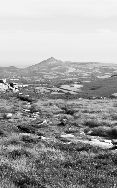
Photo: Joe King
A long distance, fully waymarked trail that takes you through the mountains from Shankill west to Tallaght and with a total ascent of around 1,100 m, the trail begins in Brady’s Pub in the heart of Shankill village (well ok, the trail actually begins on the main street beside Brady’s Pub, but why split hairs?) and continues through the suburbs (don’t worry, the views are coming) to Rathmichael and the Rathmichael Cross, once a marker between two 12th-century churches and one of many so-called Fassaroe Crosses, unusual in that it depicts a crucifixion scene on both its faces. From there you enter Rathmichael Wood, a mixed coniferous and broadleaf woodland which opens up to lovely views across to Bray Head. The trail then skirts Carrickgollogan Wood, and it’s well worth the climb to its 276-m summit, from where you’ll be able to see the Lead Mine Chimney Flue, once a part of the Ballycorus Lead Mine which operated from 1807 to 1913, with its distinctive external stone spiral staircase, the only one of its kind in Ireland. For a close-up view of the tower you can take the 2-km detour on the Lead Mines Way.
Now you make your way via Barnaslingan Wood to Barnaslingan Hill (781 ft) and its view over The Scalp, a narrow glacial valley formed during the last Ice Age and a designated Area of Special Scientific Interest. Emerging on to Enniskerry Road the trail parallels the R117 into the small village of Kilternan, after which you take the R116 and begin the climb up to Glencullen, one of Ireland’s highest-altitude villages, where you’ll find Johnnie Fox’s Pub, which also claims to be the country’s highest pub - though this is disputed by various other high-altitude establishments. The pub has an interesting history though, and was used as a meeting place by members of the 1916 Rebellion. Outside of town on the slope of Three Rock Mountain the trail passes by a Bronze Age (c. 1,700 BCE) wedge tomb excavated in the 1940s and known locally as the ‘giant’s grave’.
More road walking, this time along Ballyedmonduff Road up to Ticknock Forest and the summit of Three Rock Mountain and on to Two Rock Mountain, the trail’s high point at 1,759 ft where you’ll find the remains of a Neolithic passage grave. A ridge walk to Tibradden Mountain (1,532 ft) then descends through a forest of oak, beech, Scots pine and Sitka spruce before passing along the north slope of Cruagh Mountain and down a series of minor roads into the Glenasmole Valley, a lovely slender gorge, home to green-winged and small-white orchids and a declared Special Area of Conservation. Following the Upper Reservoir of the Bohernabreena Waterworks and the River Dodder (dammed in the 1880s) down to the Lower Reservoir, the trail continues along the Dodder through housing estates and into Tallaght’s Sean Walsh Memorial Park, an oasis of landscaped parklands, where the trail ends.