Caribbean: The Lesser Antilles - Insight Guides (2016)
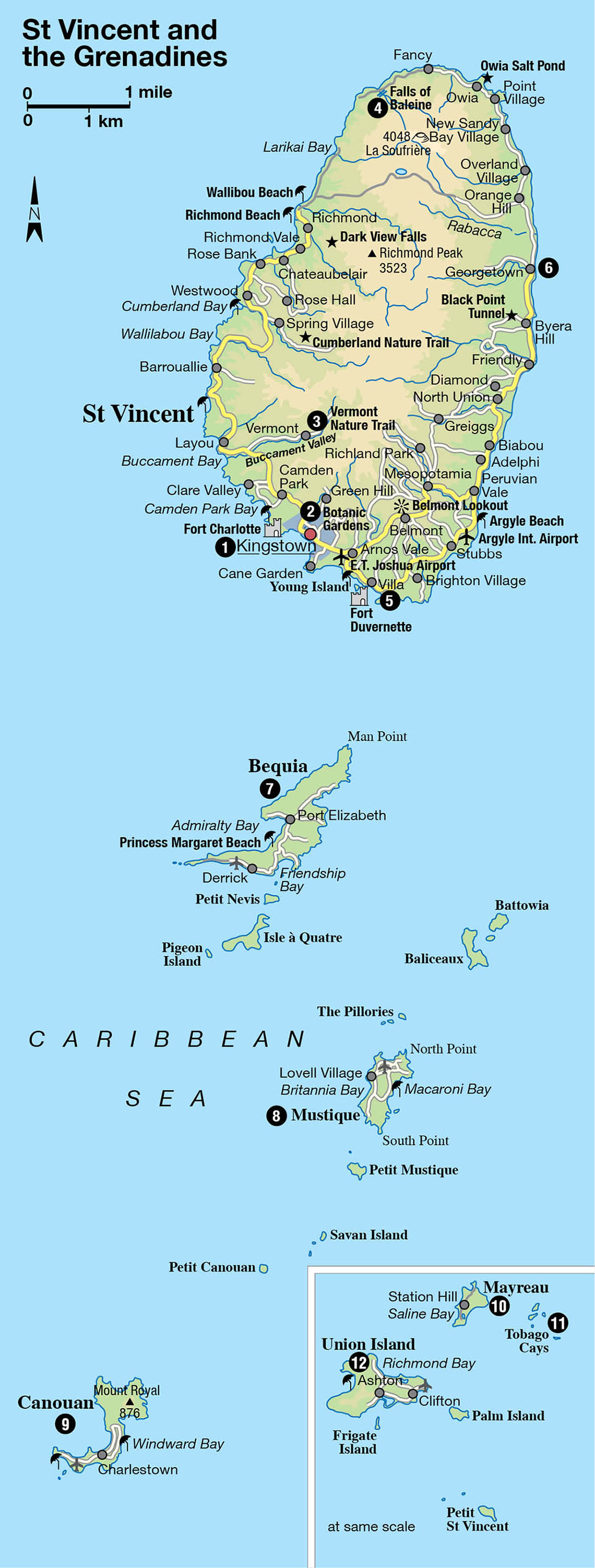
ST VINCENT AND THE GRENADINES
Volcanic and lush, St Vincent is a nature lover’s paradise, while the numerous Grenadine islands have some of the world’s finest beaches and a sea of incredible blue for adventurous sailors.
Main Attractions
St Mary’s Roman Catholic Cathedral of the Assumption
Botanic Gardens
Vermont Nature Trail
Falls of Baleine
Black Point Tunnel
Bequia
Tobago Cays
A savored retreat for West Indians themselves, St Vincent and its 32 sister islands and cays, scattered like shells dropped from a child’s overflowing bucket, are still untouched by the overt hand of tourism. There are no neon lights, no high-rise buildings, no traffic jams, no brand-name fast-food joints, no crowds, no noise.
Trekking to Soufrière volcano.
St Vincent & the Grenadines Tourist Office
Between St Lucia in the north and Grenada to the south, only eight of the islands are inhabited, accounting for a population of 103,000, most of whom live on St Vincent. The largest, at 18 miles (30km) long and 11 miles (18km) wide, the lush, craggy island of St Vincent is presided over by the somnolent volcano La Soufrière (4,048ft/1,234 meters). The “untouched” islands of the Grenadines, encompassing only 17 sq miles (44 sq km) altogether, are havens of natural beauty whose charms extend across some of the most beautiful beaches in the world into seas of many hues, rich in marine life - perfect for sailors and divers, and for beachcombers in search of privacy.
The populated islands
Among the populated islands, Mustique and Petit St Vincent are the hideaways of the rich and famous while the coral reefs of Bequia, Canouan, and Mayreau offer spectacular diving and snorkeling. Union Island, the most southerly, is the sailing gateway to the region. St Vincent and the Grenadines, which receive around 200,000 visitors every year, offer the beauties of nature but with creature comforts such as relatively easy accessibility, comfortable places to sleep, and the pleasure of a good meal in a restaurant. The size of an island’s tourist industry is loosely based on the length of the airport runway. The small one at St Vincent’s E.T. Joshua Airport allows only small planes to land here, meaning no mass tourism. A new international airport, currently under construction at Argyle on the eastern side of St Vincent, is scheduled to open in 2016. It will have four times the capacity of the existing E.T Joshua Airport, so its opening should certainly give a boost to the country’s tourism.
Forceful Caribs
The first settlers on St Vincent in the 17th century were Africans. In 1675, the resident Caribs rescued some shipwrecked slaves, and these were subsequently joined by escaped slaves from St Lucia and Grenada. The mixing of the two produced the “Black Caribs,” distinct from the indigenous “Yellow Caribs,” and eyewitness reports of the time describe many a battle between them. It was not until the early 18th century that St Vincent was finally settled by the French after many wrangles with the Caribs, who were not going to let go of their domain without a fight. They eventually lived alongside the French in an uneasy truce.
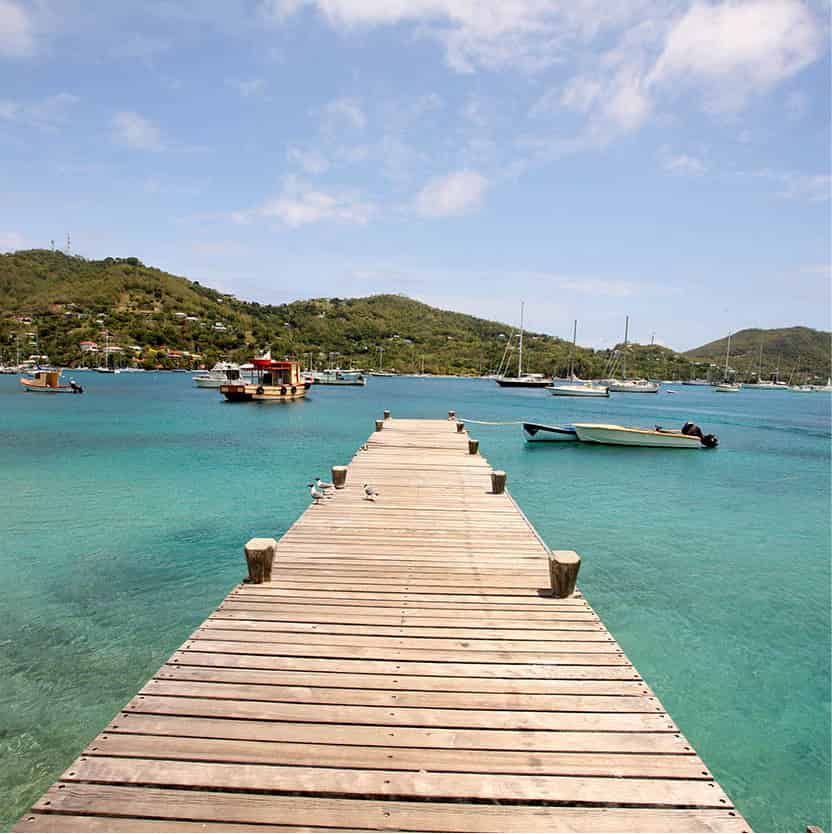
The jetty at Bequia.
Chris Calidcott/St. Vincent & the Grenadines Tourist Office
In 1722, the British moved in and until 1783 France and Britain were involved in a tug-of-war over the island, already planted with indigo, cotton, tobacco, and sugar. Alongside this conflict the Black Caribs waged war against the British colonists in what is known as the Carib Wars. These were finally ended in 1797 when 5,000 Caribs were deported to Roatán, an island off Honduras. There is still a small settlement of the Black Carib descendents in the north of St Vincent.
From prosperity to poverty
By 1829 St Vincent contained 98 sugar estates manned by slaves. After Emancipation, immigrants came from Portugal and India to work the land and the present population is largely a mixture of these three nationalities.
However, natural disasters took their toll in the form of a hurricane in 1898 and an eruption of La Soufrière in 1902 - two days before the catastrophic eruption of Montagne Pelée on Martinique (for more information, click here) - which killed around 2,000 people, mostly Caribs, and finished off the plantation economy.
Run-down and poor, St Vincent and the Grenadines was granted independence in 1979, just a few months after another volcanic eruption had wrecked the agriculture of the island, already suffering from a series of hurricanes.
Kingstown
In the mornings, the cobblestone streets of Kingstown 1 [map] are full of uniformed school children, government workers, cab drivers, people peddling sandals, and old women selling odd collections of goods from upturned cardboard boxes. Hustlers coax tourists on rides to the volcano or to the Falls of Baleine, or try to sell recordings of local calypsonians and bands such as Blaksand and New Direction. As the afternoon heat grips the town, government officers, bankers, and lawyers take their lunch at the Bounty, a café on Halifax Street, or the more cosmopolitan rooftop restaurant in the Cobblestone Inn, a converted sugar and arrowroot warehouse in Upper Bay Street.
Nonetheless, this town, little more than several dusty blocks carved in a rugged shoreline, is the heart of St Vincent and the Grenadines. There are no buildings of colonial grandeur here, but St Mary’s Roman Catholic Cathedral of the Assumption, beside Victoria Park to the west, makes up for this by providing a fascinating selection of architectural styles and features in one - Romanesque, Moorish, Byzantine, and Flemish spires, turrets, towers, belfries, crenellations, and castellations are all here - built throughout the 19th century and 1930s. Opposite, the old Anglican St George’s Cathedral has some wonderful stained-glass windows, which feature red angels.
Tropical treats at the beach.
Chris Caldicott/St. Vincent & the Grenadines Tourist Office
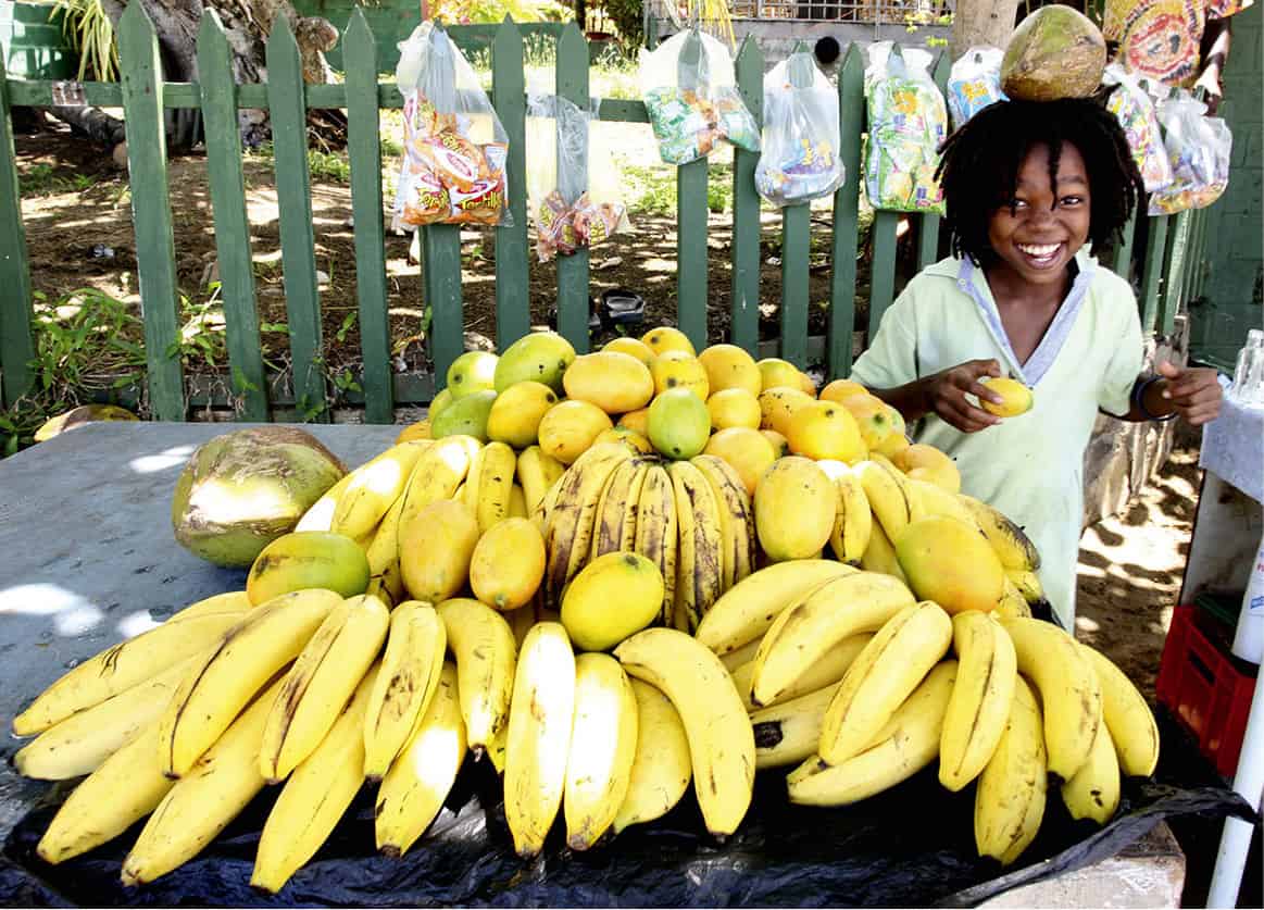
Kingstown may be the most visible source of activity in this tiny nation, but the real power comes from the rich volcanic soil. This is an island of farmers, a place where almost everyone knows how to furrow a hillside to plant sweet potatoes. On Friday and Saturday you get an idea of just how productive that soil is when farmers ride into town loaded down with their produce: fruit and vegetables like ginger, breadfruit, cashews, dates, and cassava. Trade in the Central Market on Upper Bay Street is brisk and colorful.
On the reclaimed land on the harbor in front stands the concrete Little Tokyo Fish Market, built with Japanese aid, to nurture support for continued whaling in the region. Minibuses bound for the rest of the island depart from here.
In the port, the dockside hubbub reaches a crescendo once a week when the Geest Industries freighter arrives to ship the week’s crop of bananas to the rest of the world. The banana industry suffered when the preferential agreement with the EU ended in 2006, but the crop still accounts for around 35 percent of St Vincent’s exports and makes a significant contribution to the island’s economy.
Fact
St Vincent is the world’s largest producer of arrowroot. Once mainly used as a sauce thickener, the starch from the rhizome now coats computer paper. The creamy-white flowered plant, which grows up to 6ft (2 meters) tall, was named by the Tainos who used it as an antidote for poisoned arrow wounds.
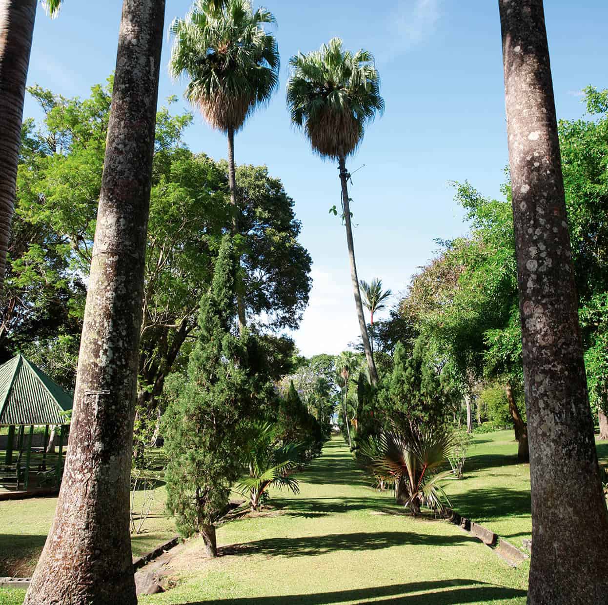
The oldest botanic gardens in the West
Leaving Kingstown via the Leeward Highway to the west, on the edge of town you come to the Botanic Gardens 2 [map] (daily; free), the oldest in the western hemisphere, founded in 1765 to propagate spices and medicinal plants. Chances are young men - unofficial guides - will approach you at the entrance and offer you a tour of the 20-acre (9-hectare) gardens that contain teak and mahogany trees, and nearly every flower and tree that can grow in the Caribbean, including a 50ft (15-meter) breadfruit tree, one of the original seedlings brought to the West Indies in 1793 by Captain Bligh on his famous ship the Bounty.
Perched some 600ft (180 meters) on a promontory above the town, 15 minutes’ drive to the west, the ruins of Fort Charlotte, built in 1806, command spectacular views across the Caribbean to the Grenadines and, on a clear day, as far as Grenada, 60 miles (95km) away. In the barracks a series of paintings (from 1972) portrays the early history of St Vincent.
General vista at the Gardens.
Chris Caldicott/St. Vincent & the Grenadines Tourist Office
Parrots and petroglyphs
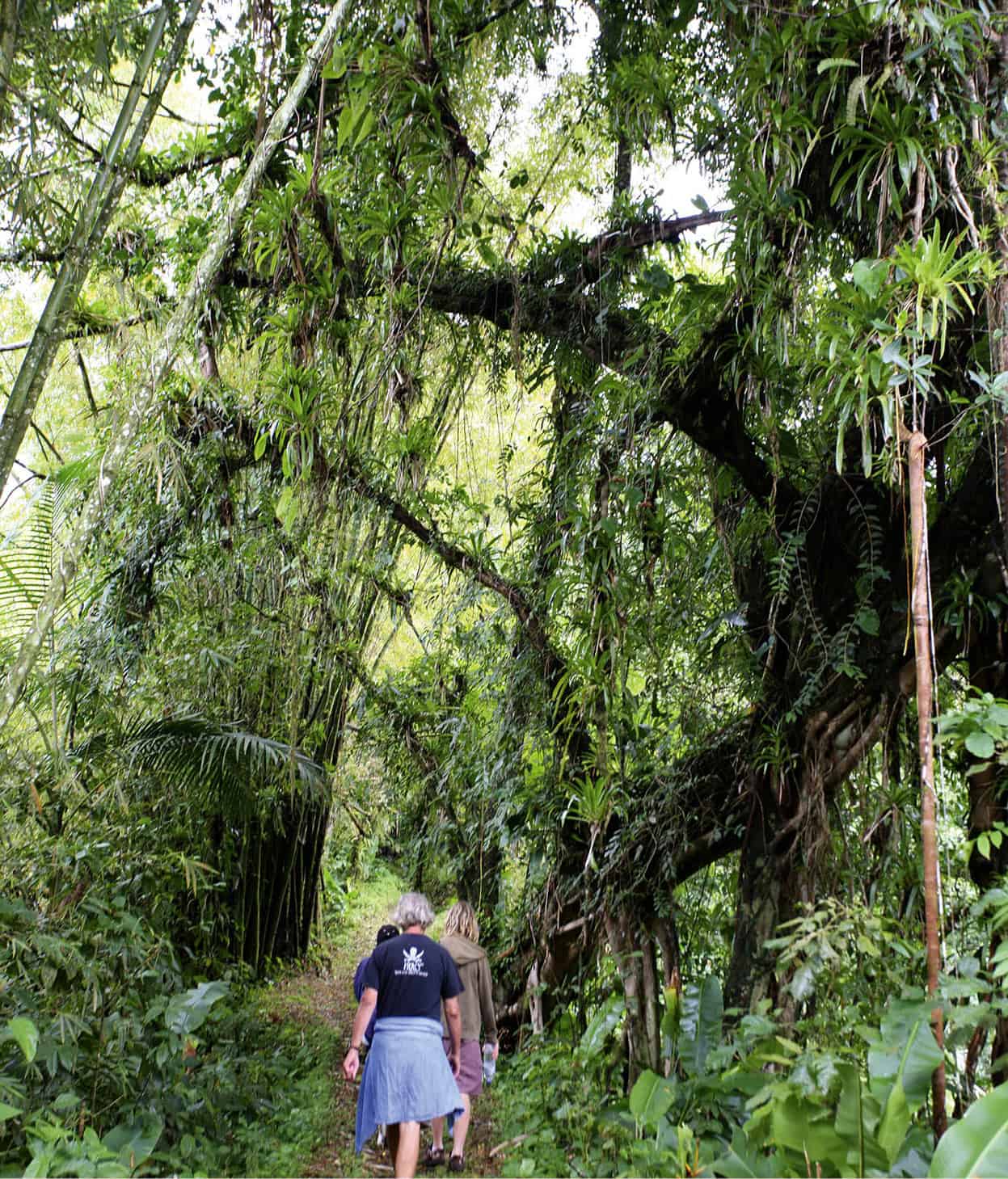
The Leeward Highway provides a dramatic 2-hour drive along the west coast with beaches of gold or black sand. In the Buccament Valley about 2 miles (3km) from Kingstown you can wander through rainforest along the 2-mile (3km) Vermont Nature Trail 3 [map]. Maps of hikes are provided at the information center and you may see the endangered St Vincent parrot or the whistling warbler, both unique to the island. Fishing villages dot the coastline and in places there are petroglyphs dating back thousands of years. There is one just north of Layou, another in the playground of a school in Barrouallie. Wallilabou Bay was a location for the movie Pirates of the Caribbean, with copies of 18th-century buildings erected to represent Port Royal in Jamaica. Several of the Grenadines also became movie sets. Richmond Beach, under the dark gaze of La Soufrière, marks the end of this beautiful winding road and a boat is necessary to go any farther. Many boat operators offer trips - which can include snorkeling and a lunch stop - to the Falls of Baleine 4 [map], 7 miles (11km) away at the northern tip of the island. There you can swim in the pools filled by these freshwater falls in a river that flows from the volcano.
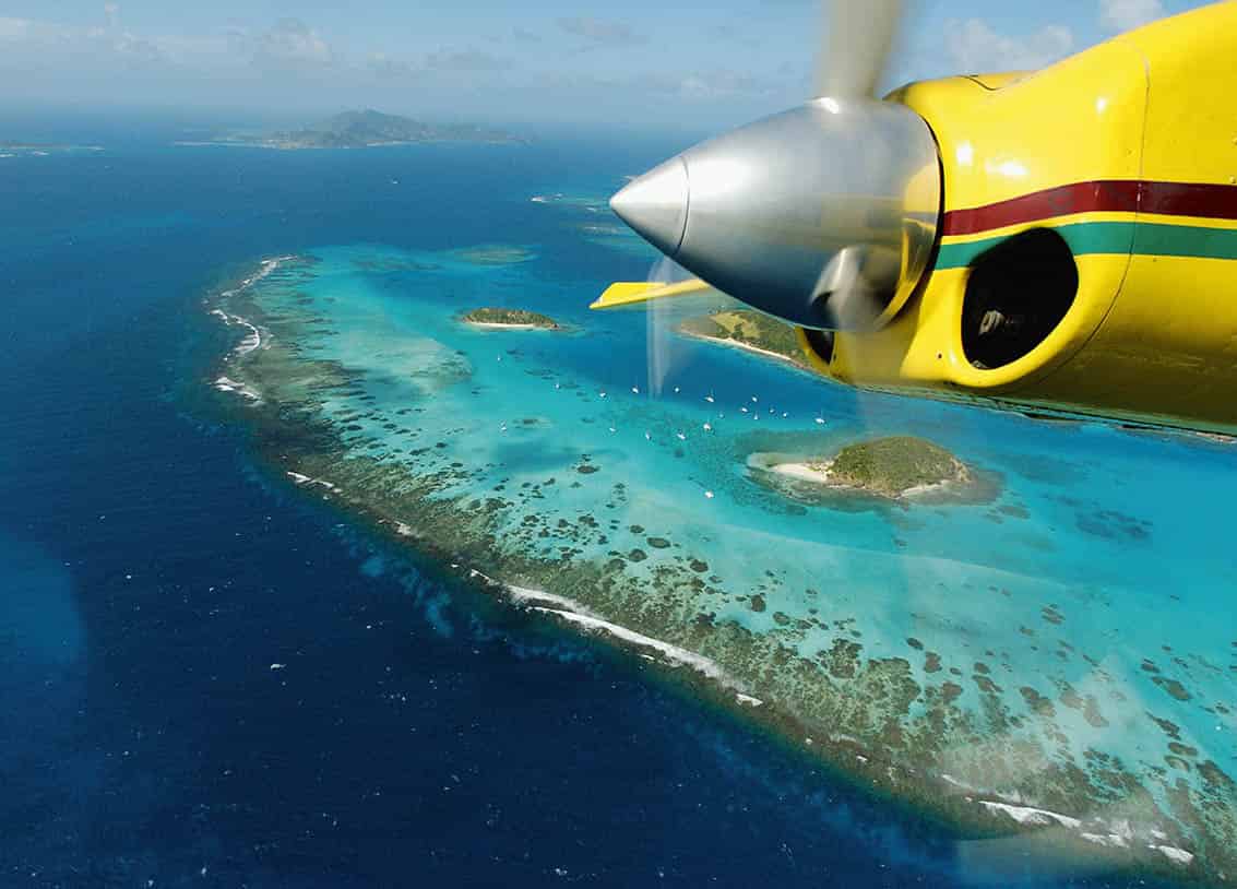
The Grenadines are equally stunning, if not more so, when viewed from above.
Getty Images
Along the Windward coast
The E.T. Joshua airport, east of Kingstown, is about 15 minutes away. Close by is the Arnos Vale cricket ground, the home (or shrine) of Vincentian cricket. Vincentians love their cricket and support their team in droves, making a match a festive social occasion with loud music and dancing no matter which team wins.
A little farther east, on the south coast road, Villa 5 [map], colloquially known as “The Strip,” is the island’s main resort area, with several hotels, guesthouses, restaurants, bars, and water sports facilities. Just 200yds/meters offshore, the tiny, privately owned resort on Young Island, linked to the mainland by a small water-taxi, becomes officially child-free between January 15 and March 15. Beside it on a rock is 19th-century Fort Duvernette.
The road winds through what the Vincentians call their island’s “breadbasket.” On the Atlantic side the soil is more fertile and from the unbarricaded road you have somewhat frightening views of deep valleys dotted with farms and banana plantations. The Mesopotamia Valley offers challenging walks through forests and plantations. From the 900ft (275-meter) viewing platform of the Belmont Lookout you get a good view over the valley, the remnant of an extinct volcano, and a major agricultural zone, still home to agouti, manicou, and other wildlife.
You may experience the odd traffic jam on the Windward Highway, the narrow coastal road that leads north to Georgetown, but they are usually caused by drivers stopping for a chat, or someone going to inspect fish for sale on the roadside. The island gets drier the further north you go, with yellow sandstone cliffs over black-sand beaches. Black Point Tunnel is 350ft (106 meters) long, built in 1815 by Carib and African slaves. After it was blasted through the rock, sugar estates in the north were able to transport their sugar through it to be loaded onto boats at a jetty on Byera Bay for export. This was another movie location, for Pirates of the Caribbean: Curse of the Black Pearl.
Fact
At least three times a day banana farmers will inspect each stalk to see if there are leaves pressing against the fruit. Bruised fruit will not be accepted by the buyers.
Georgetown 6 [map], the second-largest town on St Vincent, was once the prosperous sugar capital of the island: when the price of sugar fell, the sugar plant that employed most of the laborers in this valley was closed. Now there’s a sense of driving through a ghost town, although rum is still produced nearby by St Vincent Distillers (tel: 784-458 6221; visits by appointment; free). Formerly the Mount Bentinck refinery, the distillery produces a range of rums using imported molasses, although locally the most popular is the 84.5 percent alcohol Sunset Very Strong Rum.
A little farther on is the Rabacca Dry River, once a hot river of lava. You can drive or walk along here to well-marked trails that lead to the crater of La Soufrière. A 6-hour round trip, it is an arduous hike best begun very early in the morning, and only by the fit and healthy, but it is worth the effort when you finally crest the rim and look down into that awesome volcano. It is often cloudy, cold, and wet at the top so come well equipped and take a guide.
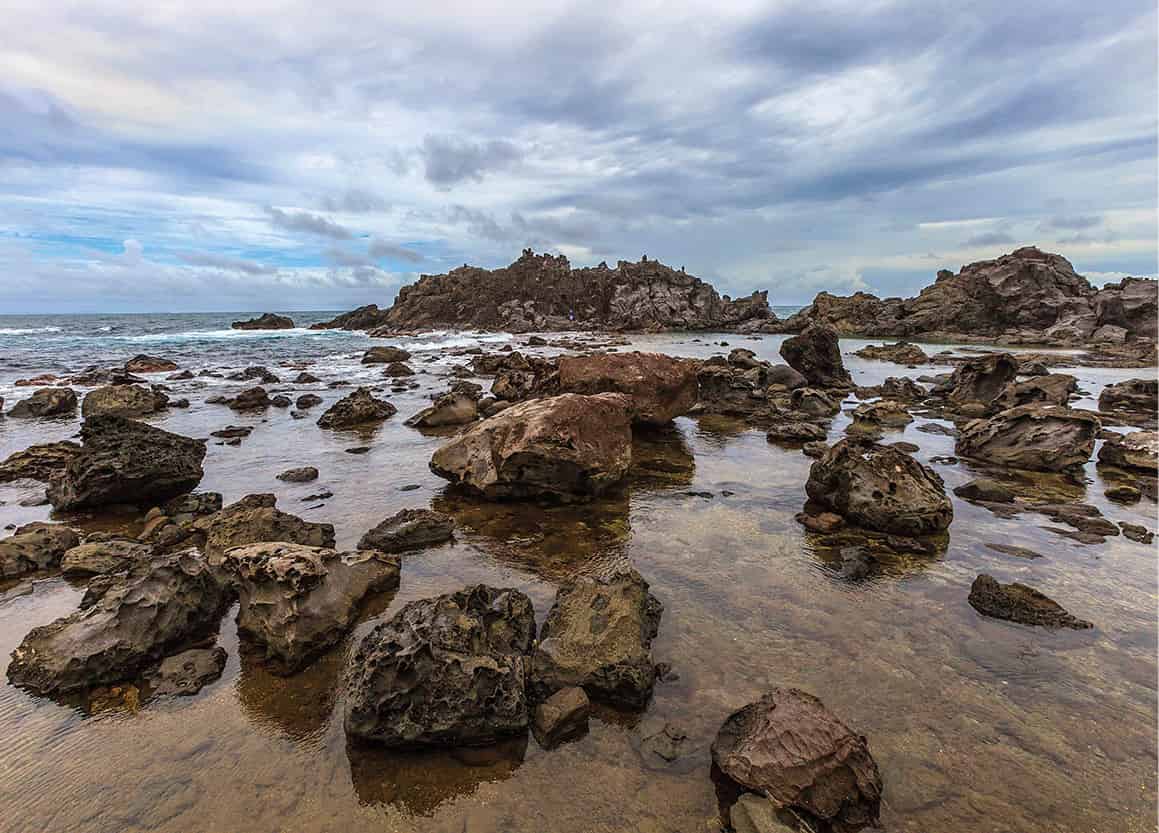
At the northern tip of the island is Owia Salt Pond, a natural swimming pool protected from the crashing Atlantic surf by volcanic rocks. Facilities have been built here, with parking, a craft center, bar, washrooms, and showers. Owia and the next village, Fancy, are where the Black Caribs live and the area is very poor, isolated, and rugged.
Owia Salt Pond.
iStock
Island-hopping
Most people arriving on an island in the Grenadines do so by sea. Anchorages are provided to protect the coral reefs surrounding the islands. Water-taxis zip around the bays waiting to take yachtsmen on shore, and boys often come out to the boats with goods for sale. Ferries regularly leave Kingstown for the islands, and Bequia, Mustique, Canouan, and Union Island all have small airports for light aircraft.
The focal point of Bequia 7 [map] (pronounced “bek-way”), 9 miles (14km) from St Vincent, is the stunningly beautiful Admiralty Bay, an enormous, clear harbor bordered by steep green cliffs, holding several yacht anchorages. Around the island is a Marine Protected Area looking after 30 superb dive sites, many of which are suitable for snorkeling too. Port Elizabeth is a thriving little community with guesthouses and a full range of stores including a yacht chandler, bank, and internet café. Along the shore sloops are built by the skillful local boat builders.
During the 19th century, the New Bedford whalers used Bequia as a whaling station. The island’s last whale harpoonist, the late Athneal Oliverre, lived in a small house in the south, which he turned into a whaling museum. The front door is framed by a whale jawbone and inside is a vertebra of the first one he killed in 1958. When and if a whale is caught (Oliverre caught his last one in 1992 - the International Whaling Foundation permits the islanders to harpoon two a year), the whole island comes to watch.
Mustique 8 [map], 15 miles (24km) south of St Vincent, is a clean and manicured island where privacy and quiet are prized by those who can afford the phenomenally expensive, luxury villas. The whole island, with its beaches and offshore waters, is a conservation area. You can walk around the island, take a picnic to Macaroni Beach on the Atlantic side, where there is palm-thatched shade, or snorkel at Britannia Bay or any of the other lovely bays on the Leeward side. Yachties congregate at Basil’s Bar (www.basilsbar.com), the place to be seen, and there is a path from there to the Cotton House Hotel, which is the only other watering hole.
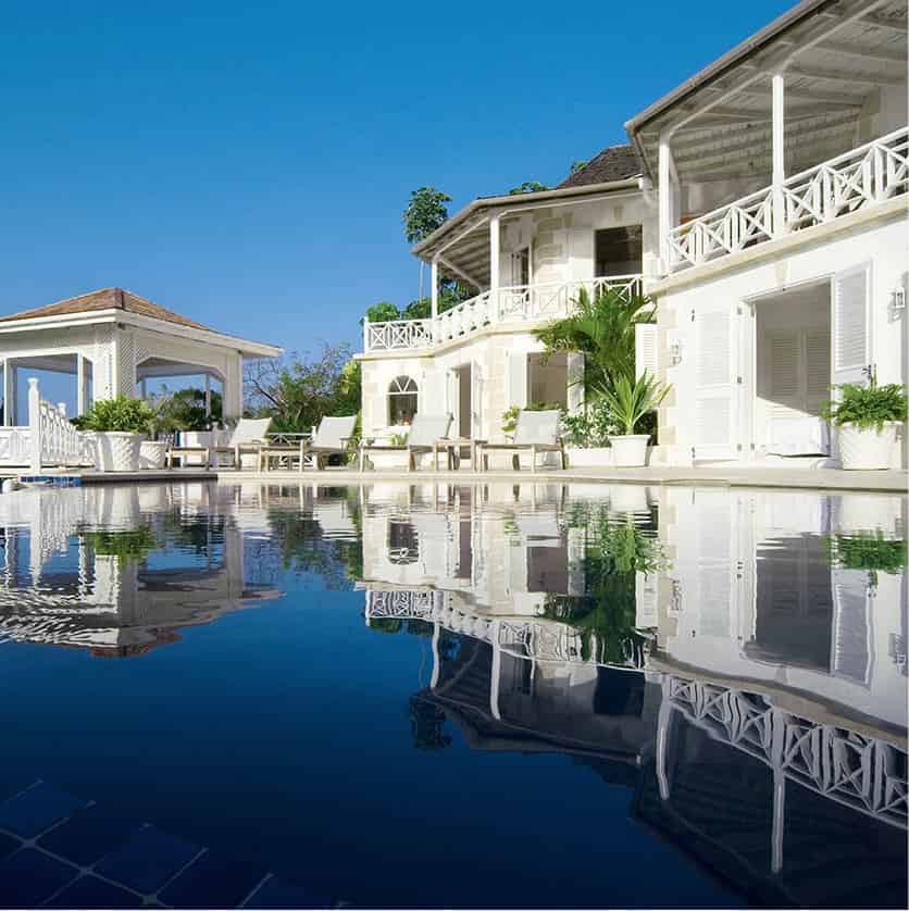
Callaloo Villas, luxury accommodations on Mustique.
Callaloo Villas
The small, crescent-shaped island of Canouan 9 [map] has some of the Caribbean’s best and most private beaches. There is also a luxury resort, complete with the Grenadines’ only golf course. Tiny Mayreau ) [map] is less than 2 sq miles (4.5 sq km) and inhabited by about 250 people. There are no roads, a small salt pond, and one very quiet resort. Nearby a tiny clutch of five uninhabited islands, known as the Tobago Cays ! [map], offers spectacular snorkeling and diving, popular with day-trippers. In order to preserve the area a National Marine Park is being developed.
Mountainous Union Island @ [map], the most developed of the smaller Grenadines, is the region’s sailing center, and an ideal starting point for trips to the surrounding islands. Across the bay is beautiful Palm Island, formerly Prune Island and now a popular resort with Caribbean islanders seeking peace.
Farthest south is Petit St Vincent, an island resort considered to be one of the best in the region, where exclusive privacy is the order of the day.