Caribbean: The Lesser Antilles - Insight Guides (2016)
MONTSERRAT
Where once Montserrat was a sleepy backwater, the still-active volcano has put the island on the map, making it a tourist attraction like no other.
Main Attractions
Montserrat Volcano Observatory
Montserrat National Trust
Little Bay
Rendezvous Bay
Silver Hills
Jack Boy Hill lookout
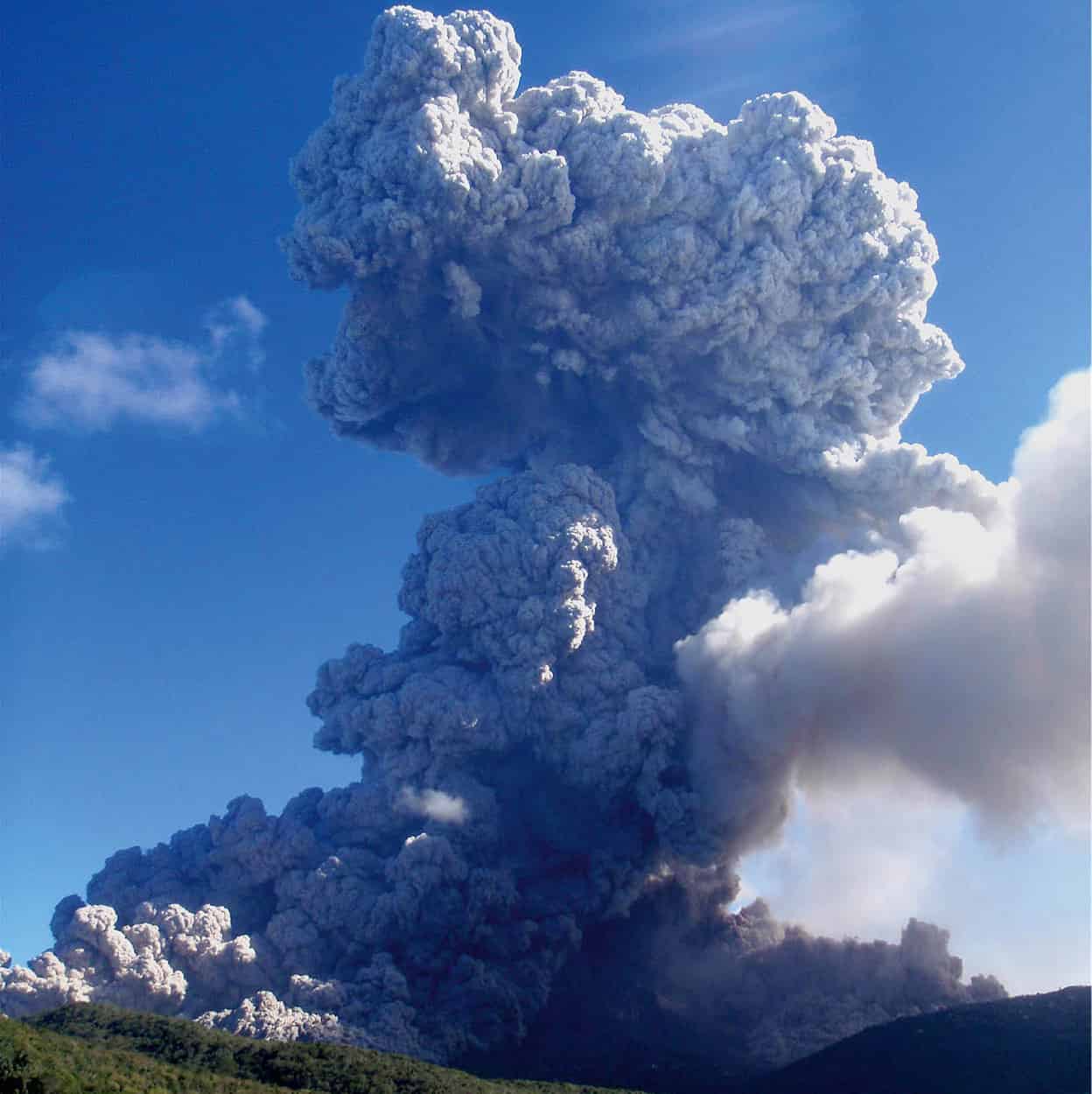
The people of Montserrat are still rebuilding following the volcanic eruptions in the Soufrière Hills that started in July 1995 and which destroyed much of the infrastructure in the southern part of the island. The mountain above Long Ground, which spewed pyroclastic flows of rocks, ash, and gases over the crater rim at 80mph (130kmph), destroying many homes and livelihoods, continues to be active. After the initial explosion, subsequent flows devastated villages and towns, including the capital Plymouth, and in June 1997, 19 people died. Then, following a relatively quiet period, its dome collapsed again in May 2006, removing about 100 million cubic meters of lava and making it the second largest collapse of the eruption. The explosions sent ash nearly 12 miles (20km) up into the air, the highest recorded so far. The island is still on the alert.
Dramatic view from the Volcano Observatory.
Montserrat Volcano Observatory
Before the eruption 11,000 people called the island home; now fewer than half remain. There is a resilience and determination in those who wouldn’t, or couldn’t, leave, and those who returned to rebuild the island.
How Montserrat used to be
Life “before the volcano” had been normal. This tiny, pear-shaped island of 11 by 7 miles (18 by 11km) - a British Overseas Territory - formed a gentle society. Its people were mainly farmers cultivating the rich volcanic soil, civil servants, construction workers, or in the tourist industry. Visitors loved “old-fashioned” Montserrat (“How the Caribbean used to be” was the marketing phrase) and, at one time, rock stars such as Paul McCartney and the late David Bowie came to record at Sir George Martin’s Air Studios, which was a victim of Hurricane Hugo in 1989 and ceased operations.
Plymouth had once been pastel pretty, with gingerbread houses in the Caribbean vernacular style. Everywhere had been green, except for the beaches, which were volcanic black.
An Irish-Catholic sanctuary
By the time Columbus saw the island during his second voyage to the New World - and named it Montserrat (Serrated Mountain) after the mountainous ridges near the abbey of the same name outside Barcelona - the original Amerindian inhabitants were no more. The first recorded settlers in post-Columbian times were Irish and English Catholics seeking sanctuary from Protestant persecution on St Kitts.
By the middle of the 17th century, a typical Caribbean colonial structure, with an economy based on sugar, had been established: a small Anglo-Irish planter class developing a social, economic, and political power base over a growing number of African slaves. When the sugar industry collapsed, and a post-Emancipation society developed, limes and cotton were introduced, soon becoming the backbone of the economy. Gradually, a greater degree of autonomy was won from the British. Today, there is a locally elected government with a British governor responsible for security and external relations.
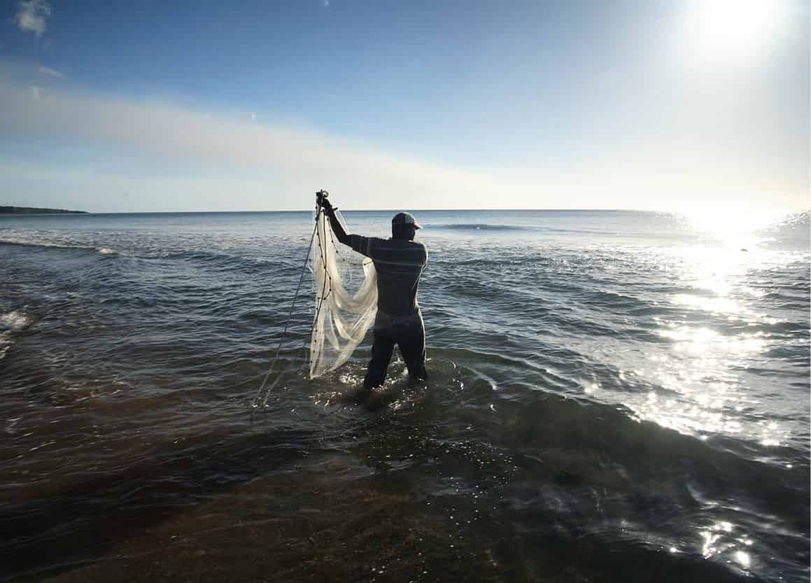
A fisherman casts his nets.
David Mac Gillivary/Montserrat Tourist Board
Life in the “safe zone”
The island is now divided into the northern “safe” zone and the southern “exclusion” zone. Everyone lives in the northern areas untouched by the volcano. Its wilder landscape ends in steep cliffs, and beyond the dark sea are the purple outlines of St Kitts and Nevis on one side and Antigua, on the other. The infrastructure has been rebuilt in this safe part of the island - protected from the volcano by the Centre Hills running from east to west through the middle of the country. Access to all areas south of Foxes Bay and Jack Boy Hill to Bramble airport and beyond is prohibited. There is also a maritime exclusion zone around the south coast, which has inadvertently benefited the local marine life. The dive sites off the north coast are also doing well, with healthy coral teeming with fish and a variety of sponges.
A new airport, now called John A. Osborne airport, was built near the village of Gerald’s. Funded by the British government, it opened in 2005 and is the main link to other islands; there is also a ferry service between Little Bay and St John’s, Antigua.
An island tour
Signposting on the island isn’t always as good as it should be, so if you rent a car don’t be afraid to ask directions. The roads in Montserrat wiggle, climb, and plunge, so proceed with caution. Alternatively hire a taxi for a day.
The Montserrat Volcano Observatory 1 [map] (visitors’ center tel: 664-491 5647; www.mvo.ms; Mon-Thur 8.30am-4.30pm) is located in a purpose-built complex uphill from Salem in Flemings. Staff at the observatory issue weekly updates on volcanic activity, which is monitored constantly. You can get a spectacular view of the volcano, Belham Valley, and ash-covered Plymouth from the viewing deck. Visits are self-guided and there is an interesting documentary describing the history and impact of the eruption (hourly 10.15am-3.15pm).
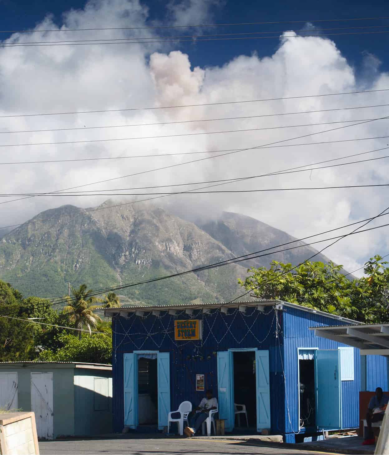
This bar in Cudjoe Head has a volcanic backdrop.
David Mac Gillivary/Montserrat Tourist Board
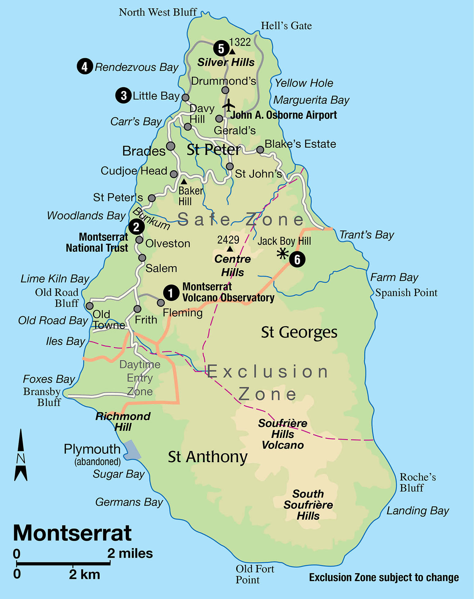
Downhill and north of Salem, the Montserrat National Trust 2 [map] (tel: 664-491 3086; www.montserratnationaltrust.ms; Mon-Fri 9am-4pm) in the Oriole complex, Olveston, stages several exhibitions each year and has a botanical garden, a research library, and a gift shop. They can also provide information on a series of nature trails in the hills. Hiking and birdwatching are increasingly popular on Montserrat and forest rangers are on hand to guide visitors. The Centre Hills Project is helping to protect species such as the Montserrat oriole, the mountain chicken (actually a frog), and the galliwasp lizard, as well as many endangered plants.
The Runaway Ghaut is half a mile (800 meters) from the National Trust, on the main road. A ghaut is a ravine or channel taking rainwater from the mountains out to the sea. Visitors can walk the mile-long scenic track to the west coast, following the line of the last retreat of the French who constantly fought the British for control of the island. Two black-sand beaches on this part of the coast are Woodlands Beach, which has a covered picnic area on the cliff above the beach, and Bunkum Bay, which has a beach bar. The sea at Woodlands is for strong swimmers only, because the beach shelves very quickly and the waves can be quite strong.
Most of the island’s shops, banks, the tourist office, and government buildings can be found in Cudjoe Head or in Brades, or on the road between the two. Just north of Brades is Carr’s Bay, where there are the remnants of an old fort, with cannon pointing out to sea.
A new capital
Little Bay 3 [map] port and town are being developed as the new capital for the island. Already there are several bars, restaurants, a nightclub, and dive center. A cultural center (tel: 664-491 4242; www.themontserratculturalcentre.ms), built by former record producer Sir George Martin as a gift to the people of Montserrat, opened in 2007. Built into the hillside, it is the largest building on the island and has an auditorium seating 500 and an amphitheatre with capacity for 2,500. Little Bay is also the location of Festival Village, an entertainment venue by the sea, and a new cricket ground.
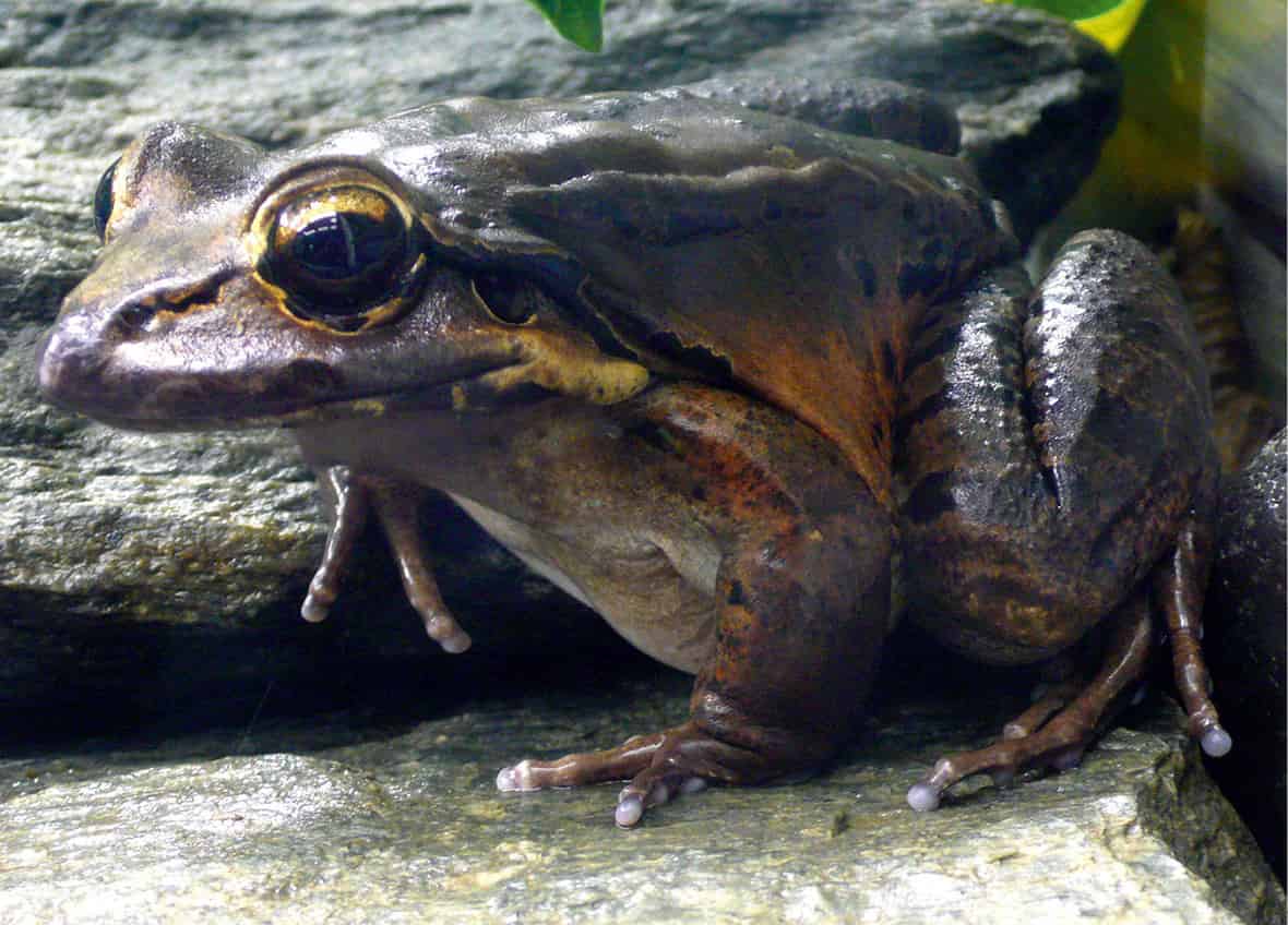
A little confusingly, the giant ditch frog is known locally as the mountain chicken.
Public domain
Just round the bluff to the north of Little Bay is the island’s only pale-sand beach, at Rendezvous Bay 4 [map]. You can either hike from Little Bay or take a short boat ride, or kayak. There is good snorkeling on the reef offshore. The 1-hour trail starts behind the concrete-block company in Little Bay, climbs over the hill and steeply down the other side to the beach.
Tip
The Guide to Centre Hills, on sale at the Montserrat Tourist Board (www.visitmontserrat.com) and the Montserrat National Trust, contains descriptive and detailed information about the species, hiking trails, and plants found in the forest on Centre Hills.
North and beyond the airport is the village of Drummonds, a good place to begin a walk to Silver Hills 5 [map] (1,322ft/403 meters). There is a communications tower at the top of the hill, and from here, on a clear day, you can see over Montserrat’s northern coastline to Antigua, 27 miles (44km) away. There is a second trail to Rendezvous Beach from here, but it is a long, hot hike of 3.5 hours with no shade, so take a hat, sunscreen, and plenty of water. There is a picnic spot and another excellent viewpoint at Jack Boy Hill 6 [map], on the east coast, where you can see the old airport in the valley below, and look south to where the pyroclastic flow wiped out the villages in its path.
View of Guadeloupe’s islands.
Jean-Marc Lecerf/The Guadeloupe Island Tourist Board