Caribbean: The Lesser Antilles - Insight Guides (2016)
SABA
A tiny volcanic peak jutting out of the crystal clear waters of the Caribbean and Atlantic, Saba’s dramatic mountain scenery matches the magnificent underwater world around it.
Main Attractions
The Bottom
Windwardside
Mount Scenery
Saba Marine Park
There are no white sandy beaches on the Dutch island of Saba (pronounced “Say-bah”). This miniature volcanic island’s rocky slopes climb steeply out of the tropical sea, rising to 2,885ft (870 meters) at the top of cloud-covered Mount Scenery. Rugged cliffs, the refuge for a variety of seabirds, support 5 sq miles (13 sq km) of green, mountainous terrain dotted with small villages of pretty, pristinely kept, white houses with red roofs, which were once linked only by hundreds of steps.
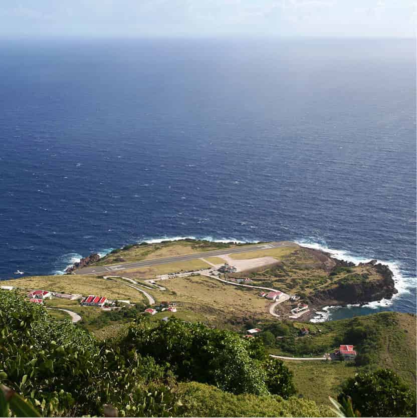
Saba’s craggy coastline with the nail-biting airport runway just visible.
Fotolia
Fewer than 2,000 people live here, half of them light-skinned and the other half dark-skinned, and they all speak English, although Dutch is the official language. As no plantation economy ever existed, slaves were only brought over to help on the small farms and carry goods up and down its paths.
As on St-Barths, 30 miles (50km) to the northeast, landing on Saba is a nerve-wracking experience. The pilot heads straight for a vertical rock face, only to fly a sharp, cool curve to the left just as you feel that your time has come, and then lands seconds later on a runway the length of an aircraft carrier - 1,300ft (398 meters) to be precise - so that his 10 or so passengers can disembark safely. Saba’s airport, completed in 1963, is only open when the trade winds are gentle enough. Getting here has never been easy: in earlier days, arriving by sea was not much better as there were no natural harbors for protection against the strong currents and fierce gusts of wind.
Shipwrecked
Christopher Columbus “discovered” Saba in 1493, but it was only in 1632 that the first Europeans - a couple of shipwrecked Englishmen - first set foot on the island. Later, eager Dutch settlers from St Eustatius, 17 miles (27km) to the southeast, managed to brave the waves that crash regularly against the steep coastline. Ruled a dozen different times by the Spanish, French, and English, Saba was finally taken over for good by the Dutch in 1812. In 2010, on the dissolution of the Netherlands Antilles, its status became that of a public body (often referred to as a “special municipality”) of the Kingdom of the Netherlands.
Fort Bay
The only inlet in the towering cliffs where boats are able to dock is at Fort Bay 5 [map], which is a relatively flat bay by Saban standards but with none of the luxuries of a proper harbor. Before 1972, when the pier was built, anyone who disembarked here - or at Ladder Bay on the west coast - always got their feet wet after being rowed ashore in wooden jolly-boats. The first vehicle on the island, a jeep, was landed in 1947 on two sloops lashed together to form a makeshift raft. These days, day-trippers from Sint Maarten, 28 miles (45km) to the north, arrive on high-speed ferries almost daily and the dive shop in Fort Bay gets very busy.
The first part of the road that staggers across the craggy terrain to the airport was built in 1943, under the auspices of Josephus Lambert Hassell. After Dutch engineers had declared any road construction to be impossible, Hassell took a correspondence course in civil engineering and proved them wrong. Before that, on landing at Fort Bay, people had to walk up hundreds of stone steps to the main village of The Bottom, and cargo had to be carried, including once a piano that took 12 men to get it to its destination.
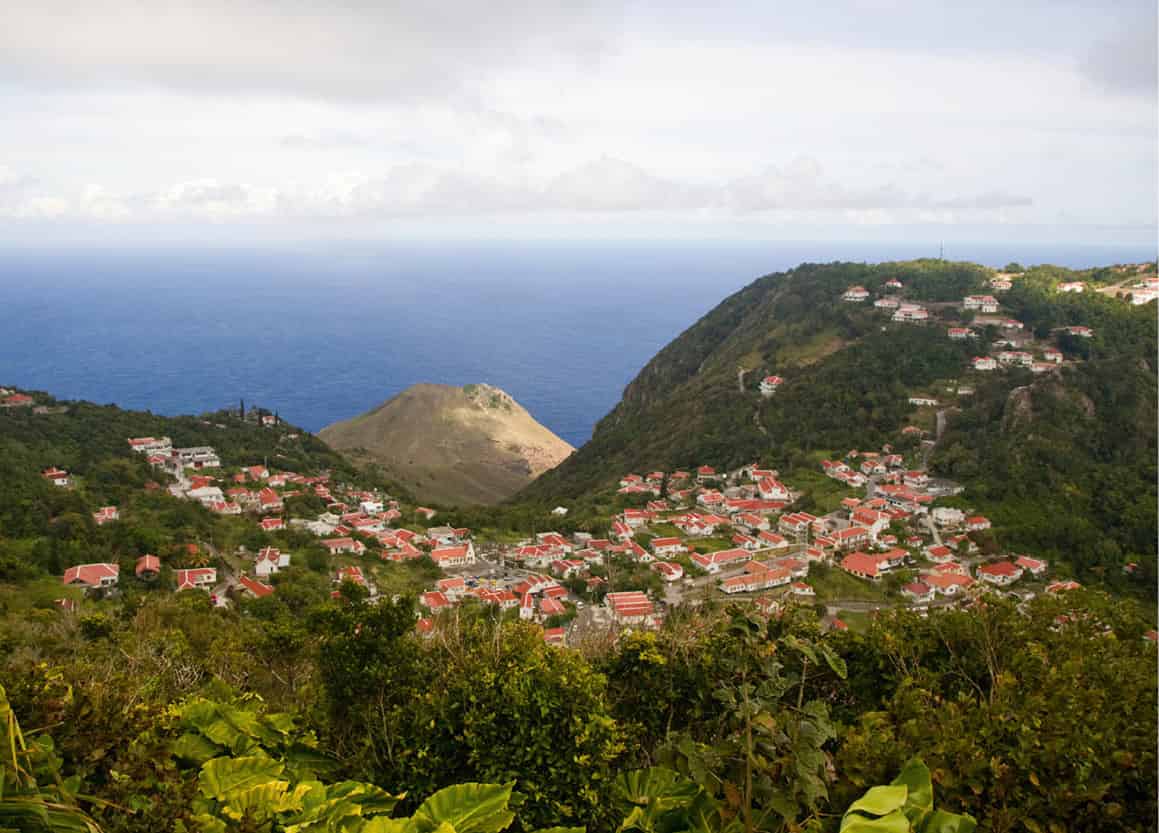
The idyllic setting of Windwardside.
iStock
From The Bottom to the Top
At 820ft (250 meters) above the sea, The Bottom 6 [map] does not live up to its name. In fact it is derived from de botte, the Dutch word for a bowl, as it stands on a small piece of flat land surrounded by mountains. With around 500 inhabitants, the village functions as the island’s capital, and the government building is surrounded by the hospital, school, Cranston’s Antique Inn - the first guest house, established in the 1830s - and a few bars. American students from the small medical school there give it a youthful ambience.
The road only reached the picturesque village of Windwardside 7 [map], 900 steps farther up, in 1951 and, despite the souvenir shops selling Saba lace, a bank, some dive shops, and a few small hotels and restaurants, it still remains very much a Dutch Caribbean idyll in its peaceful setting against a green mountain ridge between the haze-covered Mount Scenery and Booby Hill. Pretty white wooden houses on granite foundations, and gardens full of flowers in vivid bloom, decorate the village.
The red roofs are all very clean - they have to be as they are used for collecting rainwater, for there are no rivers on the island. What at first appears to be a family crypt in the vegetable gardens or orchards turns out to be the property’s own cistern, which is crucial to survival, and you may see a grave beside it - there is little room for cemeteries here.
The Harry L. Johnson Museum (www.museum-saba.com/HLJohnson; Wed, Fri 11am-2pm, Sun 1.30-3pm), set in a flower-filled meadow, was once a sea captain’s house, built in 1840, and it still has the original kitchen. A wall covered with ships’ masters’ certificates shows how closely the men of Saba are associated with the sea. For centuries, they earned a living as fishermen and mariners, plying the Caribbean trading routes. One Saban sailor is reputed to have been paid in gold for smuggling escaped French prisoners from Guyana to Trinidad.
Nearby, the home of road builder and engineer Josephus Lambert Hassell has been converted into a little shopping mall with an art gallery and a restaurant. Farther up the village are the tourist office with helpful staff, a bank, a shop, and a post office.
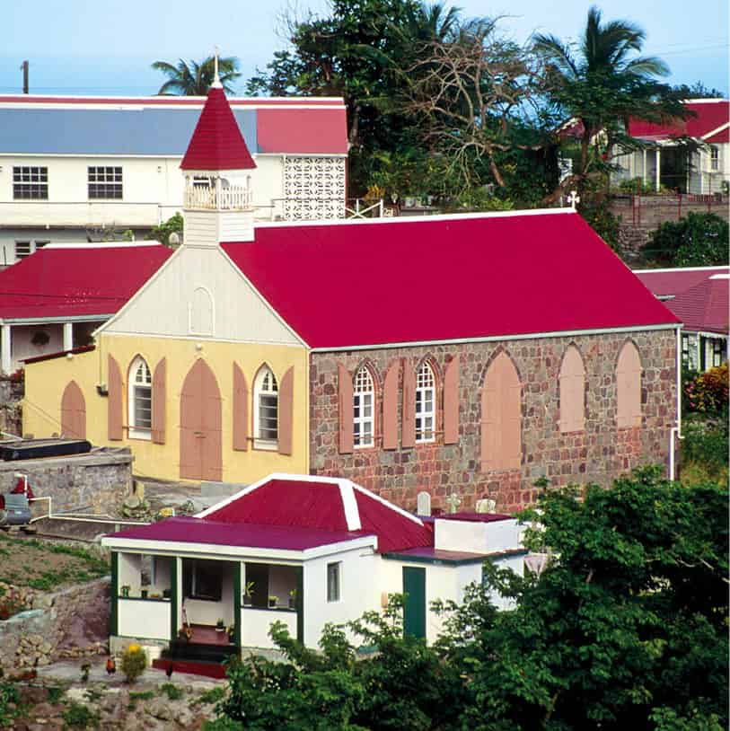
A church on the island.
iStock
Climbing Mount Scenery
It is not a good idea to wait for a completely clear day before climbing Mount Scenery 8 [map], as you might have to wait a very long time - the summit rarely peeks out of its thick cloud veil. The ascent begins on the outskirts of Windwardside (on the road to The Bottom) and you don’t need to be an expert climber, although good shoes will make the 3-hour tour easier because the 1,064 steps along the way are steep and often wet.
Lizards scurry across the path at the start of the trail and the bright red and yellow artificial-looking heliconia that grace the lobbies of smart hotels all over the world grow wild among the trees. The higher you climb, the more luxuriant the vegetation becomes: the trees are covered in lianas (tropical vines), massive leaves darken the path, and the fog closes in. Then, just beneath the summit, a 210ft (64-meter)-high radio tower (brought up in just one day by a helicopter) comes into view. The stormy wind whips through the trees and whistles through the steel structure, and behind it Mount Scenery drops away.
Muriel Thissell National Park
Other hiking trails around Saba may not be so dramatic but are just as satisfying. On land that used to be owned by the Sulfur Mining Company, the Muriel Thissell National Park extends from Mount Scenery to the north coast and the sulfur mine, and has a choice of trails in forest and scrubland. Before you set off, you should register at the Saba Trail Shop (Windwardside, tel: 599-416 2630; www.sabapark.org; Mon 1-4.30pm, Tue-Fri 9am-4.30pm, Sat-Sun 10.30am-2.30pm) where you must pay a maintenance fee.
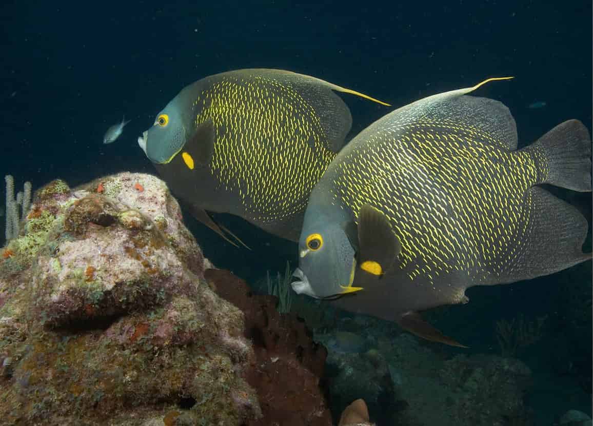
French angelfish off the coast of Saba.
Fotolia
Volcanic underwater landscapes
Do you get cold hands after a 50ft (15-meter) dive? That will be no problem at the Hot Springs site, where divers can plunge their hands into the warm sand. From 1987, the waters around Saba have been protected as part of the Saba Marine Park, concealing a vast, spectacular volcanic landscape rich in sea life and accessible to divers.
A small entrance charge to this colorful experience is charged by the diving schools, or by the organizers of boat excursions from Sint Maarten. The 26 diving grounds - only accessible by boat - provide divers at all levels with unbelievably beautiful spots, such as Tent Reef Wall, encrusted with corals and sponges, or the gently sloping reefs where elegant stingrays cruise and nurse sharks sleep in the sand.
At Third Encounter, what must once have been an underwater volcano rears up to just 100ft (30 meters) below the surface. A pillar of coral, called Needle’s Eye, has grown up on its western flank over the millennia - a unique collection of tube and barrel sponges, star coral, elephant ears, and brain coral.
Drink
Everyone has a secret recipe for the aromatic dessert drink, Saba Spice. The main ingredient is always rum, while the mix of brown sugar, cloves, fennel, and other flavorings tends to vary. Try it and see.
The Saba Bank, 2.7 miles (4.3km) southwest of Saba, is the largest submarine atoll in the Atlantic Ocean and has some of the richest diversity of marine life in the Caribbean Sea, providing a nursery for fish, lobster, and other marine life. It is the world’s fourth-largest submerged coral island, rising 0.6 miles (1,000 meters) from the sea floor, and it is still growing. It is enclosed by an Exclusive Economic Zone of the Netherlands and it is forbidden for tankers, cruise ships, or other large vessels to anchor on the bank.