A World Without Ice - Henry N. Pollack (2009)
Chapter 3. WHEN ICE RULED THE WORLD
Three feet of ice does not result from one day of cold weather.
—CHINESE PROVERB
Some 120,000 years ago, in what would one day be known as Finland, caribou grazed in the waning days of an unusually cool summer. The previous winter had delivered heavy snowfall, and as the brisk winds and shorter days of fall set in, there were pockets of last winter’s snow remaining in sheltered crevices and shadowed valleys. This residual snow gave a head start to the next annual white blanketing of the land, and reflected some of the Sun’s rays back to space even earlier than usual, thus discouraging those occasional warm fall days before the onset of winter. And that next winter lasted a little longer as well, and springtime melting got a late start; at the end of the foreshortened summer there was even more residual snow to turn away the radiant energy of the autumnal Sun. It did not take many such downward-spiraling years to yield summertime snow cover over the entire region, forcing the caribou and the woolly mammoth to find new grazing farther south. The growth of an ice sheet had begun, one that would, over the next hundred thousand years, cover much of the land of Europe and North America with a blanket of ice two miles thick, and freeze the surface of high-latitude ocean water.
At its maximum extent the ice covered Canada, Greenland, Iceland, and Scandinavia completely. Most of the British Isles, Germany, Poland, and Russia, all the way to the Ural Mountains and beyond into the West Siberian Plain, were beneath the ice sheet. The ice extended into what is now the United States as far south as the modern Missouri and Ohio rivers and east over New England. High mountains beyond the margin of the ice sheets—the Rockies and Sierra Nevada in North America, the Alps and Pyrenees in Europe, and the high ranges of Asia—also developed glaciers.
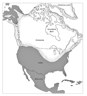
Maximum extent of ice over North America during the most
recent ice age, from about 120,000 to 20,000 years ago
In the Southern Hemisphere, Antarctica was completely blanketed, and the high peaks of the Patagonian Andes, in South America, and on the South Island of New Zealand were strongly shaped by ice that flowed all the way to the sea. Even in Africa, astride the equator, Mounts Kilimanjaro and Kenya and the peaks of Uganda’s Ruwenzori Range hosted extensive ice.
At sea, ice was widespread as well. More or less permanent sea ice covered the entire Arctic Ocean and reached all the way to Iceland, in the Atlantic. In the Pacific, ice extended south into the Bering Sea, between Alaska and the Russian Far East. The Southern Ocean surrounding Antarctica also had a year-round icy surface, reaching northward to the sixtieth parallel of south latitude. Seasonal sea ice in both hemispheres extended the range of ice even farther, but it is unlikely that the Drake Passage, between the Antarctic Peninsula and South America, ever was completely closed, because the strong winds and currents blowing through there did not let ice take hold.
Thick piles of ice, widely spread over Earth’s surface just twenty thousand years ago—that is quite a concept. In fact, it was not until the late nineteenth century that scientists embraced the idea of widespread ice in the recent geological past. And geologists have since learned that this was only the most recent great ice excursion to spread over the Earth—one of a score or more that rhythmically advanced and retreated during the last three million years.

WHAT IS IT that geologists see that leads them to envision such a different world, a time in the history of Earth when there was much more ice on the planet than there is today? The evidence comes from both the land and sea, underfoot and underwater. On the land are multiple signatures in the landscape of an earlier presence of ice, and in the sea is evidence of the complementary signature—a reduction in water. The latter tells where the H2O came from; the former tells where it went.
CLUES FROM THE LAND
When agriculture expanded from its beginnings in the Fertile Crescent of Mesopotamia into the plains of central and northern Europe, settlers found a terrain strewn with rocks and boulders, of all sizes, shapes, and colors. It was as if a giant spice bottle had been shaken overhead and had laid down a motley layer of pepper and paprika, sage and saffron, cloves and cinnamon over the ground. These silicate mega-spices were embedded in fertile silt and clay, and were so abundant and presented such formidable obstacles to plowing and planting that farmers were forced to clear boulder fields in order to gain enough area for crops. When Europeans came to the New World, they discovered that much of the northern United States and Canada was similarly strewn with a blanket of debris. Early farmers worked long days to move the boulders to the periphery of the fields or to stack them along the property line between neighbors, thus providing the setting for Robert Frost’s poem “Mending Wall,” with the memorable phrase “Good fences make good neighbors.”
These boulders, heterogeneous in size, shape, and composition, are very different from the sediment in other geological layers. The mechanism for transporting sediment most familiar to early geologists is running water, which tends to segregate materials of different sizes—moving small-size particles along while leaving larger and heavier pebbles and boulders behind. Moreover, the tumbling of pieces of rock in a stream-bed tends to break off the sharp corners, eventually leaving the stones very well rounded. Similar rounding occurs on ocean beaches, where the incessant pounding of the surf produces well-rounded grains of sand. No, this blanket of mixed-up rock, of all sizes and shapes, was not laid down by water. It was simply dropped by whatever transported it so widely—and even “widely” is an understatement. This blanket of rock rubble can be found draped over some six million square miles on three continents of the Northern Hemisphere.
Ice was eventually recognized as the distributor of the debris. Unlike moving water, which sorts, rounds, and winnows the rock fragments it encounters, ice does none of these things. The key to understanding how ice picks up and delivers rocks to new locations was found by observing mountain glaciers, such as those seen in the European Alps and the Rocky Mountains of North America. But first, a few explanatory words about the mechanics of mountain glaciers: As snow accumulates in high areas year after year, the deeper layers get compressed into ice by the newer snow above. As the ice thickens, it slowly spills out of its catchment basin and begins to creep downhill, in a river of ice that flows a few tens of feet each year, truly at a “glacial pace.” The ice descends to lower elevations, where it meets warmer air, and at some point the temperature reaches the melting point of ice. Beyond that point the glacier is steadily transformed into an ever-growing stream of meltwater.
As glacial ice descends from the heights, it erodes whatever bedrock it encounters, plucking and scraping rock from the walls and floor of the valley through which it flows. The debris is rafted along with the flowing ice to lower elevations. The load is transported to the terminus of the glacier, that is, the place where ice melts as fast as it is delivered from above. At the terminus, the rock is deposited as an arcuate mound called a terminal moraine. The ice front, the snout of the glacier, may seem to be stationary, but in fact newer ice is always moving to the front, to meet the ultimate fate of melting. On its flow to the front, the glacial ice continues to carry rock debris for delivery to the moraine. The process is somewhat like placing suitcases on a descending escalator—they are transported to the bottom, where they are unceremoniously dumped, and simply pile up. As the glacier melts, the rocks are abandoned as a jumble of rough-around-the-edges newcomers from the heights, now relocated to a lower landscape. If the climate warms, the ice front will melt back farther up the valley, but the terminal moraine will remain where it was deposited, offering testimony to the greater reach of the glacier in earlier, colder times.
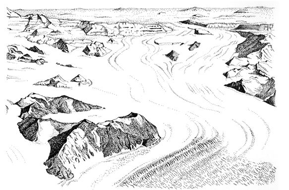
Large glacier spilling off the south polar plateau through
the Transantarctic Mountains, in Antarctica
LIKE A HOT KNIFE THROUGH BUTTER
Ice is a powerful shaper of the landscape, and not only by conveying rock from one place to another. The great boulder fields strewn widely over large areas give testimony to the vast extent of the ice sheets, and today’s mountain glaciers demonstrate the ability of ice to transport rock from myriad source areas. As impressive as those characteristics of ice are, the description of ice streams and ice sheets is incomplete without drawing attention to the titanic erosive power of moving ice. It is the power to excavate, bulldoze, break, crush, and pulverize rock as it moves over the terrain, the power to sculpt mountains and carve out valleys. There is almost nothing in the terrain that can withstand the prolonged passage of ice or forestall its reshaping of the landscape.
As ice succumbs to the pull of gravity and is drawn downward, it assaults the mountaintops where it has accumulated. The slow but persistent flow of ice in many directions away from the summit pulls rock from all sides, sharpening the top into a pointed and angular shape, recognized in the descriptive names humans have given them: the Matterhorn, the Beartooth, the Sawtooth. Once rock has been trapped beneath moving ice, it acts like coarse sandpaper on the bedrock below it, gouging and grooving the bedrock, leaving behind long striations that indicate the direction in which the ice moved. These scratches can be seen on glaciated terrains everywhere, from Glacier National Park in Montana, to the Upper Peninsula of Michigan, to Central Park in New York City, a clue that ice passed over these places.
But running water and even wind also modify the landscape, so geologists have had to observe carefully to identify characteristics unique to each type of landscape. The deep main valley of Yosemite National Park in California is U-shaped in cross-section, a characteristic of erosion by ice, in contrast with V-shaped valleys, which have been cut into mountainous terrain by streams of water, such as in the headwaters of the Ganges and Indus rivers high on the Tibetan Plateau.
Erosion by ice and water differ in other respects. Water is exceptionally agile, and can find and follow low pathways in virtually any topography. It can zigzag through the terrain, giving rise to valley systems that are anything but straight. Ice, on the other hand, is like a big, stiff, lumbering giant, making its way downhill with much less meandering. Rather than go around obstacles in the terrain, as water does, ice just plows through them, straightening, smoothing, and widening the terrain like a bulldozer blazing a new highway. The resulting valleys carved by ice have steep sides and smooth, round bottoms—the U shape mentioned earlier. They are deep, and offer a long and unobstructed view. The Finger Lakes of upstate New York, so named because of their long and narrow configurations and parallel development, are examples of valleys scoured and straightened by ice.
When valley glaciers erode deep U-shaped valleys all the way to the sea, the trough will become a fjord when seawater enters the valley after the ice has melted. Given the ample depth of fjords, oceangoing vessels can cruise tens and sometimes hundreds of miles “inland” along these valleys. These elegant topographic features are special remnants from the recent ice ages. They do not occur just anywhere; they form under only a certain set of conditions. A look at a world map, one that shows enough topographic detail, including fjords, reveals that they are well developed only along the west coasts of panhandle Alaska, Canada, Greenland, and Norway in the Northern Hemisphere, and along the west coasts of southern Chile and the south island of New Zealand. What do these places have in common?
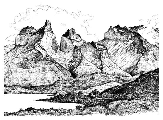
U-shaped valleys carved by mountain glaciers,
Torres del Paine National Park, Chile
First, they all are located where the prevailing winds generally pass over long stretches of ocean before reaching land, picking up substantial moisture along the way. As the wind encounters the higher and cooler elevations of the land, it gives up its cargo of water vapor as precipitation. Second, these “fjorded” coastlines are all at latitudes sufficiently far away from the equator (about 55º north or 45º south) so that during the recent ice ages, when Earth was colder by some ten to fifteen Fahrenheit degrees, the precipitation would fall as snow, and accumulate to form glacial ice. Third, at those latitudes or even farther toward the poles, it is cold enough even at sea level for glaciers to reach the sea instead of melting away while still flowing overland. Finally, because sea level is lower during an ice age, the glaciers flowed beyond today’s high sea level coastline, and continued to carve deep valleys across the temporarily exposed continental shelves. When sea level later rose at the end of the ice age, as meltwater returned to the sea, the deep glacial valleys became inundated, giving us these long scenic waterways. Fjords are truly a gift of the ice ages, and a reminder of the tremendous erosive power of flowing ice.
ICE TO WATER
The piles of debris carried and ultimately dropped by the ice sheets created an irregular and rumpled surface. When the ice melted, the earth-moving ceased. The terrain was simply left as a work in progress, much like a road construction site on a weekend or holiday. But the glacial “workforce” left the site, never to the return, at least not for tens or hundreds of thousands of years. The low places filled with water. Many thousands of small lakes dot the debris-blanketed surface of Minnesota, Wisconsin, Michigan, and the Canadian provinces to the north. In Europe there is an equivalent “land of lakes” in Finland, parts of Sweden, and the far northwest of Russia. Flying over the lake-dotted landscape late in the day, one sees the low Sun reflecting off the surface of these lakes, little jewels glistening as far as the eye can see.
The effects of glaciation go well beyond the areas overridden by ice. If the geographic extent of ice cover on land is defined by the deposits of glacial debris and the lakes nestled within, the extended reach of glaciation can be seen in the water produced as the ice melted. The volume of water tied up in the continental ice sheets is immense—major glaciations withdraw enough water from the oceans to lower sea level by six hundred feet the world over. As the ice melted, streams of water transported and deposited sediment to form the many local sand and gravel quarries now exploited in construction, road building, and manufacturing. Quite in contrast to the unsorted character of the glacial deposits, the sediment in water-laid deposits is much more uniform in size, shape, and composition.
Meltwater also accumulated to form large lakes in areas peripheral to the ice. The North American Great Lakes and the Great Salt Lake of Utah are the diminished remnants of the last big melt-off, elements of today’s landscape that give testimony to the earlier widespread ice. Great Salt Lake was once much larger, deeper, and fresher. The broad depression in the Great Basin of Utah received meltwater from the ice cover of the Rocky Mountains, to form what geologists call ancient Lake Bonneville. At its highest stand about seventeen thousand years ago, the surface of Lake Bonneville was about one thousand feet above the level of the present-day Great Salt Lake, and its water spread over much of western Utah, an area some twelve to thirteen times greater than today’s Great Salt Lake.25
Why is Great Salt Lake saline, while the Great Lakes are fresh? The difference arises because Lake Bonneville occupied a closed depression from which there was no outlet—the only loss of water possible was through evaporation. Over most of the time since the highest level of Lake Bonneville, evaporation has exceeded precipitation and stream flow into the lake. The result has been a progressive decrease in lake level and a growing concentration of dissolved salt in the diminishing water volume. Large areas of the former lake bed of Lake Bonneville are now exposed, and reveal a “pavement” of salt that makes up today’s Bonneville Salt Flats, where racing cars set world speed records in excess of six hundred miles per hour. On the sides of the mountain ranges that rise out of the Great Basin one can easily see older shorelines of Lake Bonneville, like giant bathtub rings, recording pauses in the fall of the lake level.
The five Great Lakes of North America—Lakes Superior, Michigan, Huron, Erie, and Ontario—border eight states and Canada. Together they contain 85 percent of the surface water of North America, and 20 percent of the world’s freshwater. They are all connected by rivers—the St. Marys River carries water from Lake Superior to Lakes Huron and Michigan; the Detroit River links Lake Huron to Lake Erie; and the Niagara River connects Lake Erie to Lake Ontario, with one giant leap over Niagara Falls. Lake Ontario empties into the St. Lawrence River, the final long waterway that delivers the Great Lakes water to the Atlantic Ocean.
The depressions that these lakes occupy were shaped by the North American ice sheet, which scraped away at weak bedrock to create low regions that would later host the lakes. The Lake Michigan and Lake Huron basins, which nearly surround the lower peninsula of Michigan, sit in relatively weak rocks, Paleozoic shale that was no match for a mile-thick ice sheet grinding its way south. By contrast, the Niagara dolomite, a very tough rock formation composed of magnesium carbonate, stood up better to the erosive power of the ice. The Niagara formation forms a sweeping arc around the Great Lakes—it is the backbone of Wisconsin’s Door Peninsula, behind which lies Green Bay, and of Manitoulin Island and the Bruce Peninsula of Ontario, which separate Georgian Bay from Lake Huron. As the name Niagara suggests, this rock layer also forms the durable platform on which the Niagara River flows out of Lake Erie—its lip creates the ledge where the river plunges 190 feet at Niagara Falls, on its way to Lake Ontario and the sea.
Although the lake basins resulted from glacial erosion, the water now filling them is not glacial meltwater; the water in the lakes has been replaced many times since the end of the last ice age. Rain and snow falling each year in the upper Great Lakes catchment basin replenishes the water that flows over Niagara Falls, through Lake Ontario, and outward to join the Atlantic Ocean. The annual loss and replenishment is about 1 percent of the volume of water in the lakes, so it takes about a hundred years to totally exchange the waters in the Great Lakes—pollution introduced into the lakes takes a century of flushing to purge.
There are similarities and differences between the Great Lakes and Lake Bonneville of Utah. As with Lake Bonneville, which had bigger volumes and higher lake levels in the past, so have the Great Lakes had higher stands. But unlike Lake Bonneville, the Great Lakes basins were covered by the North American ice sheet at the time of its maximum extent, some twenty thousand years ago. As the ice front retreated northward from the region, for a time the ice actually formed a barrier that prevented meltwater from exiting through the St. Lawrence River. The meltwater, blocked by the ice from flowing northeast, instead found its way into the Mississippi River and the Gulf of Mexico. Effectively the ice was a dam along the north margin of the Great Lakes, and for a while it led to higher lake levels than exist today.
Satellite photos reveal several former shorelines along the margins of Lakes Michigan, Huron, and Erie. Each of these lakes had spread over a greater area than they occupy today—and the relict lake beds, flat and blanketed with fine sediment that settled out from the ancient lakes, are put to good use. These large, level, and featureless plains make for easy use in agriculture, and are attractive sites for airports. Detroit’s Metropolitan Airport is located on the vast flat exposed lake bed of an earlier and bigger Lake Erie, twenty miles away from the western shore of today’s Lake Erie.
Another large meltwater lake once covered much of the Canadian province of Manitoba, but extended also into Ontario, Saskatchewan, North Dakota, and Minnesota. This lake, named Lake Agassiz after the nineteenth-century Swiss geologist Louis Agassiz, was big—some seven hundred miles north to south and two hundred miles across. At its maximum extent some thirteen thousand years ago, it was bigger than either California or Montana, almost two thirds the size of Texas. Its water covered an area 80 percent greater than all of the modern Great Lakes combined. This was the great lake of its time.
But Lake Agassiz returned most of its glacial meltwater to the sea. Abandoned shorelines on hillsides and a giant exposed lake bed across the plains of southern Canada and adjacent north-central United States provide evidence of the lake’s former extent. Today its much-diminished remnant is Lake Winnipeg—between Lake Erie and Lake Ontario in size—big by today’s standards, but a shadow of its former self.
As the ice sheet melted, big rivers developed to drain the immense volume of meltwater and return it to the sea. The ultimate margin of North America’s last great ice sheet can be identified by the major rivers established on the periphery. Today we know them as the Missouri and Ohio rivers, along the southern boundary of the ice sheet, and the Mackenzie River to the west. The Mackenzie flowed northward to the Arctic Ocean, but the Missouri and Ohio joined the Mississippi to drain much of the early meltwater to the Gulf of Mexico. As the ice sheet melted back, other outlets to the sea opened. When the St. Lawrence River began to drain the Great Lakes Basin, the meltwater no longer coursed south to the Gulf of Mexico—it was delivered to the North Atlantic Ocean, with profound, albeit temporary, consequences to the Atlantic circulation and climate.
LOUISIANA OF THE NORTH
In the early nineteenth century the Ohio and Missouri rivers were the pathway to the interior of the continent for the explorers Meriwether Lewis and William Clark. The Lewis and Clark Expedition had been authorized by President Thomas Jefferson shortly after he concluded the big territorial acquisition known as the Louisiana Purchase in 1803. Jefferson had purchased from Napoleonic France a huge swath of land in the interior of North America west of the Mississippi River, land that today includes all or part of fifteen states, representing almost a quarter of the area of the United States. The Lewis and Clark journey of 1804-6 had a simple purpose: to see what it was that we had just acquired from France. Wrote Thomas Jefferson:
The object of your mission is to explore the Missouri river, and such principal stream of it as by its course and communication with the waters of the Pacific Ocean whether the Columbia, Oregon, Colorado or any other river may offer the most direct and practicable water communication across this continent for the purposes of commerce.
The scholarly Jefferson was interested in much more than simply commerce, and he instructed Lewis and Clark to make friendly contact with native peoples encountered along the way, and to observe the flora, fauna, and mineral resources of the different regions. The expedition followed the Missouri River to its headwaters along the present-day Montana-Idaho border, and then crossed the Continental Divide, the great watershed that separates westward drainage to the Pacific from waters headed eastward. There they joined the Snake River and followed it to the Columbia River, their pathway to the Pacific Ocean.
The Columbia River basin owes much of its landscape to the outflow of glacial meltwater. The Columbia crosses both Washington and Oregon, flowing over and through a rock formation known as the Columbia River Basalt. These are volcanic rocks—lava flows that spilled over much of the Pacific Northwest during the mid-Miocene period, around fifteen million years ago. On top of the basalt sit a few hundred feet of wind-blown dust. This was the terrain that at the end of the last ice age was exposed to one of the most catastrophic floods in human history.
The scenario for this massive flood, which came to be known as the Spokane, or Missoula, Flood, began with the formation of a temporary ice dam in the narrows of the Clark Fork River, in western Montana, around fifteen thousand years ago. This dam caused a large lake, Lake Missoula, to form behind it, in the same way that the ice front in the mid-continent led to temporarily higher levels of the Great Lakes. When the ice dam failed suddenly, the impounded lake water burst into the drainage ways that fed the Columbia River, and poured downriver with a velocity nearing fifty miles per hour. Some estimates of the volume of water that cascaded over the terrain suggest that it exceeded the total flow of all the rivers of the world, at least for a few days.
This torrent shaped the landscape in extraordinary ways. It cut deep canyons into the basalt caprock, leaving occasional large escarpments that drop from one basalt flow to another. The lips of these escarpments display a scalloped shape, much like the Horseshoe Falls at Niagara. Indeed, giant waterfalls did cascade over these cliffs, carrying immense volumes of water that scoured deep plunge pools at the cliffs’ base. Large tabletop “islands” capped with basalt, similar to the mesas in the desert landscape of Utah and Arizona, stand isolated by channels scoured around them. This churning, turbulent sheet of water eroded huge boulders of basalt, much bigger than a house, tumbling them miles downstream and eventually dropping them in a plain marked by gigantic ripple marks, so large that the rhythmic rise and fall of the topography can be fully appreciated only from the air.
The surge of water continued toward the Pacific coast. It cut a canyon across the narrow continental shelf, at that time still exposed because of the lower sea level of the ice age. When the flood entered the sea, it dropped its sedimentary load on the ocean floor. Some of the debris had come all the way from Montana. And if one such flood was not sufficiently cataclysmic, geologists suggest that this scenario was repeated many times over the next two thousand years. Eventually, the ice retreated far enough north so that ice dams no longer formed in Montana, and outbursts no longer washed over the Columbia Plateau.
This extraordinary terrain arrayed across Washington is called the Channeled Scablands. The scale of the features in the landscape and of the processes that formed them—like continent-wide ice sheets themselves—is beyond anything in the modern human experience. These landforms stand there today—the channels carry little water, the basalt boulders tumble no more, and the falls are dry. They offer mute testimony to a time when glacial meltwater roared across this lava plateau in a massive flash flood.
Archeological evidence now documents a human presence in Oregon some fourteen thousand years ago, perhaps the earliest humans ever in western North America. Imagine the reaction of these early beings to the periodic walls of water that churned through the valleys and spread catastrophically across the landscape. The estimates of the recurrence interval of the floods are around fifty to sixty years, well within the lifetimes of early residents of the region. These floods would be the stuff of legend and oral history, passed on through many generations, similar to the historical memories of major tsunamis that have affected coastal populations in earthquake-prone regions.
When J. Harlan Bretz, a geologist at the University of Chicago, first offered the giant flood hypothesis in the early 1920s, he became an object of derision. What he had proposed was an example of catastrophism in the geologic record, a concept that gave special emphasis to the role of infrequent and improbable events in the shaping of Earth’s surface. The conventional geological wisdom of the time favored the concept of unifor mitarianism, whereby the landscape could be interpreted in terms of observed and reasonably well understood processes acting slowly over long periods of time. But Bretz persisted in offering more and more field evidence to support the flood concept, and eventually his perspective was accepted.
THE THICK PILE of ice sitting on the surface of North America and Eurasia had another remarkable effect—it formed such a massive load that the crust of Earth actually sagged beneath it. In central Canada the depression was sufficiently deep that when the ice melted and sea level rose, ocean water filled the depression, producing the large marine embayment now called Hudson Bay. Today, with the load of the ice gone, the crust is slowly rebounding upward, and spilling the seawater in Hudson Bay back into the deeper ocean basins. Just as Lake Bonneville became smaller because of evaporation, Hudson Bay is also shrinking as more and more of the continental crust reemerges above sea level.
In Europe, the center of the ice pile was in the Gulf of Bothnia, between Sweden and Finland. As in North America, Earth’s crust was depressed beneath the load of ice, and following the melting of the ice, the rock surface is slowly emerging from beneath the sea. These long-term geological processes are slowly adding territory to the maps of Canada and Fennoscandia (the geological name for the Scandinavian peninsula), a peaceful restoration of land following the invasion and occupation by the glacial ice. But whether the restoration will continue is not so clear. Post-glacial rebound will continue to uplift the still-depressed crust, but the uplift is now meeting competition as anthropogenic climate change diminishes polar ice and raises sea level. If sea level rises faster than the crust does, the sea may once again conquer the land.
ICE AGES LEAVE THEIR MARK IN THE SEA
In the ocean, the signature of an ice age can be found in the chemistry of seashells that form layers on the ocean floor. As water evaporates from the ocean and falls as snow on the growing continental ice sheets, the chemicals dissolved in the remaining seawater become more concentrated. Since small marine creatures use the ocean’s chemicals to grow their shells, the composition of their shells during an ice age reflects the more concentrated chemistry of the oceans in which they grew. When these creatures died and fell to the ocean floor, the shells accumulated as a layer of history representing a time when higher chemical concentrations indicated less water in the oceans. These stratified marine cemeteries reveal that no fewer than twenty ice ages have rhythmically paraded over the continents in the past three million years, each time borrowing water from the oceans, which forced the remaining seawater to carry a heavier chemical burden.
The particular signature of water withdrawal is in the relative abundance of one of the uncommon isotopes of oxygen: 18O. This isotope of oxygen has two extra neutrons in its nucleus, making it about 12 percent heavier than the very common isotope 16O. That extra weight makes it harder to vaporize (evaporate) water containing 18O as compared to 16O, with the result that as water leaves the ocean on loan to continental ice, 18O becomes more concentrated in the remaining seawater, leading to an increase in the ratio of 18O/16O. Consequently, the marine creatures that use the chemicals in the ocean for shell construction will record this higher concentration of 18O in their shells, which in turn is the signal of less ocean water and, by implication, that ice volumes are higher. Very clever indeed.
Under the shallow waters that now cover the continental shelves, other topographic features also indirectly point to lower sea levels. Along the eastern coast of the United States, off the present-day mouths of the Hudson River and of the Susquehanna River emptying through Chesapeake Bay are deep valleys cutting a few hundred miles across the continental shelf into the Atlantic Ocean Basin. When sea level was lower during the last ice age, the continental shelves were exposed, and these rivers had farther to go to reach the sea. As the ice began to melt, the rivers carried much more water and had greater erosive power than they do today. This enhanced river discharge and strong erosion across the exposed continental shelf cut deep valleys, which can be imaged with marine geophysical methods, the same tools that are used to explore for oil in the rocks of the continental shelf. Today these valleys, now completely submerged beneath the ocean surface, are called the Hudson Canyon and the Baltimore Canyon.
At the edge of the continental shelf, the submarine topography drops steeply into the true ocean basin. Most of the water in the oceans of course resides in these low-lying areas. The fact that today there is also ocean water atop the continental shelves is a statement that there is more water on Earth than the ocean basins can accommodate, so some of it laps onto the margins of the higher-standing continents. In geological terms, oceans are defined not by where marine waters are found, but rather by the deep basins that surround the elevated continents. Indeed, if all the ice now present on Earth were to melt, sea level would rise onto the continents another 250 feet above today’s level.
At the maximum of the last ice age, some twenty thousand years ago, sea level was lower than today by some six hundred feet, and the shoreline of eastern North America was at the edge of the continental shelf, in places several hundred miles away from today’s coastline. Icebergs discharged into the Atlantic would float along that margin, and sometimes their deep keels would drag along the bottom, carving gouges into the rock and sediment. These long scour marks can be seen on the ocean floor today off the coast of South Carolina.26
WHEN MELTWATER REACHES THE SEA
In financial markets, transfers of capital between one market segment and another can be accommodated without upsetting the market unduly, provided the transfers are in small enough parcels spread out over reasonable periods of time. An “orderly” market follows such a pattern. But if huge blocks of stock in one sector are dumped onto the market all at once, turmoil can overwhelm the marketplace.
This financial analogy is apt for thinking about transfers between the ice and ocean reservoirs in Earth’s hydrological system. As glacial ice melts in response to a slowly changing climate, meltwater forms streams that merge into rivers, and the rivers eventually reach the sea. And the freshwater of the rivers is gradually mixed into the saltwater of the oceans via the action of wind and ocean currents. The great hydrological accounting book will show the balance in the ice account slowly going down and the balance in the ocean account creeping up. In essence, there is an “orderly” shift of hydrological capital from one reservoir to another. On occasion, however, there can be abrupt shifts in the movement of hydrological capital that cause chaos in the exchange. One such moment of turmoil occurred during the melting of the last North American continental ice sheet.
Just prior to the abrupt shift, the meltwater along the southern margin of the North American ice sheet was drained by the Missouri and Ohio rivers and delivered to the Mississippi River for final passage to the Gulf of Mexico. There it mixed with warmer and saltier water, eventually making its way into the open Atlantic Ocean, where it was stirred into the general circulation pattern of the Atlantic current system. But by about 12,800 years ago, the front of the North American ice sheet had melted back to a point where the meltwater found a new and shorter pathway to the sea—the topographic lowlands that would suddenly become the St. Lawrence River Valley. Large volumes of cold meltwater no longer went the Mississippi way, but instead coursed northeastward, past the Gaspé Peninsula and into the Atlantic Ocean. There it interjected itself into the slow northward drift of the Gulf Stream, inserting a cold, fresh barrier into this warm surface current, and interrupting the delivery of heat to the far North Atlantic. A big chill fell over the region, and people living farther to the north must have wondered what happened for the heat to be turned off so abruptly.
This cold period, which chilled Iceland, Greenland, and Western Europe for more than a millennium, has been called the Younger Dryas, because in the regions affected by the sudden chill, a cold-climate flower, the Dryas, was reestablished. It had grown previously in the regions a few thousand years earlier, when these latitudes were emerging from the last glacial maximum. The end of this thousand-year cold wave came when the meltwater was reduced to a volume inadequate to maintain a thermal barrier to the Gulf Stream, which then resumed its delivery of heat to the far north, accompanied by a substantial warming of Iceland and Western Europe.27
WHAT CAUSES AN ICE AGE?
Why do ice ages come and go? What factors lead to a periodic accumulation of thick ice on the continents? These questions are more difficult to answer than simply assembling the evidence that shows that ice ages have occurred. Because continental glaciations are relatively rare occurrences in the geological record, we know that the conditions producing ice ages do not occur very often. The previous occurrence of widespread glaciation (prior to the multiple ice advances of the past three million years) was in Gondwanaland during the late Paleozoic, about 275 to 300 million years ago.
Some generalities, however, can be garnered from the geologic record. One obvious factor that plays an important role in glaciations is the location of landmasses on the globe. Land that is situated at high latitudes, where it is colder, is a more probable setting for snow and ice accumulation. Today Antarctica lies entirely within the Antarctic Circle, and much of Greenland lies north of the Arctic Circle. Conversely, where there is only open ocean at high latitudes, as with the present-day Arctic Ocean that surrounds the North Pole, there will be no thick accumulations of ice on the sea surface. Sea ice, of course, does form over the Arctic Ocean, but it is a thin and fleeting cover, with marked seasonal variations in extent, and a lifetime measured in years or perhaps decades. By contrast, accumulated land ice can survive hundreds of thousands of years. The oldest ice in Antarctica is about eight hundred thousand years old,28 and in Greenland, a little more than one hundred thousand years old.29 Other factors, such as changes in the patterns of atmospheric and oceanic circulation, play a role in making Earth susceptible to ice accumulation in the high latitudes. One such event (discussed in chapter 1) was the climatologic isolation of Antarctica brought about by the opening of the Drake Passage.
During the last three million years, conditions developed for “a perfect storm” that has led to multiple oscillations of ice over the planetary surface, with the most recent ice sheets retreating only ten to twenty thousand years ago. What happened three million years ago that set the stage for recurring accumulations and dissipations of ice? One important change was the tectonic uplifting of the Isthmus of Panama, to link North and South America. But more important than the connecting of two continents was the disconnecting of two oceans, the Atlantic and Pacific. Prior to the formation of Panama, the Atlantic and Pacific exchanged water via east-west currents that flowed through the gap between North and South America. But when Panama blocked that exchange, the Atlantic surface currents became predominantly south to north, and carried warm water into the Arctic, water that altered the atmospheric circulation and precipitation patterns in the far north. More snow began to fall, and not all of it melted in the subsequent summers. The modern cycle of ice ages had begun.
A very elementary question about the causes of ice ages focuses simply on the issue of accumulation: What conditions lead to winter snowfall greater than summer melt-off? When year after year more snow falls than melts, there is a growing accumulation—that is the scenario laid out at the opening of this chapter. It is analogous to your savings account—when year after year you spend less than you earn, there is an accumulation in the piggy bank. The conditions that favor an accumulation of snow are related to changes in the seasons on Earth, particularly at high latitudes, where it is already cold enough to make summertime melting a short-lived phenomenon. The crucial arena is near the Arctic Circle, in the Northern Hemisphere, which passes through Alaska just north of Fairbanks, across northern Canada and the southern tip of Greenland, near Iceland, through Scandinavia, across northern Russia, all the way to the Bering Strait. Anything that can slightly alter the competition between winter and summer, that leads to shorter, colder summers at that latitude, may trigger the onset of an ice age.
So what causes the seasons on Earth? Why do we have winter, spring, summer, autumn, and then another winter? There are two principal and unequal effects that lead to seasonality. The greater effect is called the tilt season, and the lesser, the distance season. The tilt season is associated with Earth’s rotational axis, that imaginary line running through the planet from pole to pole, around which Earth spins daily (and 365 times plus a fraction in its yearly journey around the Sun). The rotational axis is not, however, perfectly upright relative to the plane of Earth’s orbit about the Sun—it is tilted a little more than twenty-three degrees away from upright. That means that in the course of the year, first one hemisphere and then the other will get slightly more sunshine, because it is tilted toward the Sun. In the annual journey around the Sun, when a hemisphere is tilted toward the Sun, it experiences summer, and when it is tilted away from the Sun, it experiences winter.
The second and lesser cause of seasons relates to the fact that Earth’s orbit about the Sun is not a perfect circle, but rather an ellipse, a slightly squashed circle with a long dimension and a short one. And the Sun does not sit exactly in the middle, but rather a bit off-center, closer to one end of the long dimension than to the other. This means that as Earth follows the elliptical path around the Sun, its distance from the Sun is always changing. As Earth comes closer to the Sun, it gets a little extra sunshine, and as it moves away from the Sun, it gets a little less. This variation in solar heating during every trip around the Sun also contributes to warmer and colder periods during the year—giving rise to the distance seasons.
The tilt season and the distance season combine to produce the actual seasonal variation in sunshine, but the sum is different in each hemisphere. When the Northern Hemisphere is tilted directly toward the Sun on June 21, Earth is at the most distant part of its orbit. So, while tilting gives the North some extra sunshine, the distance effect gives it a little less, thus diminishing the heating from the tilt. Six months later, on December 21, when the Southern Hemisphere is tilted directly toward the Sun, Earth is making its closest approach to the Sun, so the tilt and distance reinforce each other. This produces asymmetry in seasonality between the hemispheres—the Southern Hemisphere has stronger seasonal variation than does the Northern Hemisphere.
That is the basic picture of how a typical year’s sunshine gets spread over the hemispheres to produce seasons, but it only shows us how seasons are established—it does not tell us what changes to this picture of seasonality would allow accumulations of snow at high latitude year after year, and initiate an ice age. That story is more complicated.
There are very small periodic variations in the amount of seasonal sunshine that the hemispheres receive through the tilt and distance effects, because the tilt of Earth’s rotational axis and the elliptical shape of Earth’s orbit about the Sun are themselves changing, albeit very slowly. These slight changes are imposed by the gravity fields of the other planets in the solar system, but the principal effects come from Jupiter, the largest and most massive planet in the solar system, some 318 times more massive than Earth.
There are three perturbations to Earth’s seasonal story that result from these planetary gravitational tugs, one that affects the distance season, a second that affects the tilt season, and a third that determines the geography of where the interactions of the other two add to or subtract from each other. These slowly changing effects are called the Milankovitch cycles, in honor of Milutin Milankovitch, a Serbian geophysicist who early in the twentieth century pointed out their importance for climate change. In the longest of the Milankovitch cycles, the shape of the ellipse becomes slightly more elongated, then slightly more circular, and then back again, while at the same time the ellipse is slowly rotating around the Sun to trace out an orbit that over a long period looks like petals of a flower. A full oscillation in the elongation takes about 100,000 years, and changes the distance contribution to the seasons.
In a second cycle the tilt of Earth’s rotation axis, currently about 23.4 degrees, oscillates between 22.1 and 24.5 degrees every 41,000 years. At greater tilts, the seasons become more extreme, and at lesser tilts, more uniform. A third cycle arises from the precession of the rotational axis—a familiar effect seen in the slow wobble of a spinning top’s axis of rotation. This changes the orientation of the rotation axis, and determines the hemisphere in which the distance and tilt season reinforce each other, as in the Southern Hemisphere today. The precession of Earth’s rotational axis makes a complete cycle with respect to the seasons in about 23,000 years—so, in half that time, the reinforcement will occur in the Northern Hemisphere, before shifting back south of the equator to complete the cycle. The maximum amplification of the seasonal contrast takes place when the orbit is most elongate and the tilt is at its maximum. The precession determines which hemisphere will receive the maximum reinforcement of the distance and tilt effects.
The effects at these three periods—100,000; 41,000; and 23,000—combine at any given time to produce a composite increment or decrement to the sunshine received at a given place on Earth. The composite is like listening to sound from an electronic synthesizer, which uses only three tones with different volume settings. The combination is usually some gentle cacophony, but from time to time there is some harmony between two of the tones, and on occasion with even one tone dominating, coming through loud and clear. The right combination of these Milankovitch factors sets the stage for snow accumulation at high latitudes and the beginning of an ice age.
Two lines of evidence suggest that for the last several hundred thousand years it has been the 100,000-year oscillation in the distance effect that is dominating the variations in sunshine and seasonality at high latitudes on Earth. One line is found in the sea, in the layers of marine fossils that indirectly provide the history of ocean water volume by way of the 18O/16O ratio. These sedimentary layers show four recent low-water stands separated by an average of just over 100,000 years. The second line of evidence comes from deep ice cores from the Russian Vostok borehole through the East Antarctic ice sheet. These cores show the same 100,000-year periodicity in the polar air temperature, with the lowest temperatures occurring at the same time that the oceans show their lowest sea level. It can be no coincidence that the coldest temperatures occur at the same times that the oceans display minimum water volume—the ocean water has been transferred to the land and frozen into an ice blanket, which is sitting on the cold continents. Earlier glacial cycles revealed in the Antarctic ice show the 41,000-year periodicity. This indicates that the oscillations in the tilt were then the dominant factor in the three-note tone poem composed by the bobbing and weaving of Earth in its long-term relationship with the Sun and other planets.
While it is clear that the Milankovitch climate cycles are the pacemakers of the ice ages, other factors come into play as ice accumulates. The albedo, or reflectivity, of Earth begins to increase, and vegetation is overridden by the spreading ice, thus altering both the polar radiation budget and carbon cycle. These changes amplify the polar chill initiated by the Milankovitch influences on seasonality.
HUMANS ON THE MOVE
The closure of the Isthmus of Panama three million years ago brought changes to more places than just the poles. The adjustments in the circulation of the oceans and the linked effects on the atmosphere led to redistribution of global precipitation. Africa, the cradle of human development and evolution, was no exception. An aridity set in that led to a cooling and drying of the continent, particularly north of the equator. Forests gave way to grasslands, and the Australopithecines, the progenitors of the modern human genus Homo, struggled to adapt. Evolutionary pressure favored new tools and skills. The emergence of stone tools marked the beginning of the so called Paleolithic period of human evolution—and the makers and users of these tools were early representatives of the genus Homo. These early humans spread widely through Africa between 2.5 and 1.5 million years ago, and later into Europe and southwest Asia. There they learned—or, to their detriment, did not learn—to cope with a slowly oscillating climate, and with ice sheets that periodically moved across northern Europe and Asia.
The archeological site at Atapuerca, in northern Spain near the city of Burgos, is known as the home of the first Europeans,30 with evidence of occupancy dating back to 1.2 million years before the present. Dr. Josep Pares is a member of the scientific team at the National Research Center on Human Evolution in Burgos (and my colleague at the University of Michigan). These anthropologists and geologists have for more than a decade been engaged in reconstructing the human history at this site. Pares’s role has been to create a time frame for the human presence at Atapuerca, using a wide array of geological and geophysical techniques to determine the age of the occupancy. In 2007 he took me to the dig and guided me into a cool dark cave and through layer after layer of sediment containing the bones and fossils and tools that tell of this early distant outpost of humanity, on its journey out of Africa and to the far corners of the world.
For the most part, this journey was on foot. It is not easy to walk around the world, but as the ancient proverb says, “A journey of a thousand miles begins with a single step.” And as various early representatives of our genus Homo left Africa, little by little they expanded into new regions of Europe and Asia, always in search of abundant food. In the last half million years the Heidelberg species of Homo, and later the Nean derthals, became established in Europe, while at the same time, back in Africa, another human species, Homo sapiens, was in ascendancy. Midway through the last ice age, some seventy thousand years ago, Homo sapiens felt the winds of climate change in Africa—a drying out that pushed food gathering to an untenable situation and thinned human populations almost to extinction.31 Thus began the final great human migration to all the habitable continents of the globe. Homo sapiens—our immediate genetic ancestors—were on the move to distant places. Their pathways around the world were opened, ironically, by the glaciation of the last ice age, a large-scale conversion of ocean water into continental ice.
What happens between water and ice that opens pathways for migration? Water and ice are two faces of the same material: H2O. Earth’s total endowment of H2O is more or less stable, but during an ice age the proportions of the H2O in ice and in water change. As noted in the earlier discussion of the isotopic chemistry of the oceans, large expanses of ice sitting on continents during an ice age represent large withdrawals of water from the oceans. One expression of the withdrawal is the lowering of sea level. This adjustment in the water budget of Earth leads to exposure of the continental shelves, and provides a dry land human migration path that in more temperate times would be covered by shallow seas. The broad, shallow platform between Southeast Asia and the many islands of Indonesia, Papua New Guinea, and Australia provided a partial walkway of migration that led to human occupancy of Australia by fifty thousand years ago.
Another migration pathway of early Homo sapiens led eastward across Asia to the Kamchatka Peninsula and the Chukotka region of the Russian Far East, some thirty thousand years ago. The maximum of the most recent ice age was still ten thousand years in the future, and sea level would drop still farther. The peopling of the Americas was a direct consequence of exposing the seafloor across the Bering Strait and along the Aleutian Islands arc. The Bering route, some thousand miles across at its widest, brought people to the Arctic regions of Alaska, Canada, and into the mid-continent of North America by fourteen thousand years ago.
The flow of people along the Aleutian route went to southern Alaska and southward along the western coast of North America. Evidence of humans in coastal North and South America32,33 also dates from around fourteen thousand years ago. It’s a long walk from Alaska to Patagonia, around nine thousand miles. But over a thousand years, it really amounts to a slow diffusion into new territory, some ten miles or so each year. There would be ample time for these folks to pick the berries and smell the roses, and marvel at the new world they were occupying for the first time. With the spread of humans into the Americas, the dispersal of Homo sapiens into all the habitable continents had reached completion. 34 And just in time, for the great melt-off of the glacial ice sheets had begun, and the land bridges from Asia created by lowered sea level were disappearing fast. The newcomers to the Americas were on their own.
The last ice age was nearing an end, and the ice front continued to retreat northward. Yes, there were interruptions to the fast warming of the climate: the sudden drainage of the large transient meltwater lakes—the Younger Dryas event that cooled the Northern Hemisphere for a millennium between 11,500 and 12,500 years ago, and another later, shorter drop in temperature 8,200 years ago, when Lake Agassiz emptied much of its water quickly into Hudson Bay and on into the Atlantic. But these were the last gasps of the ice age—temperatures around the globe reached levels similar to those of today, and remained more or less at that thermal plateau for the next 8,000 years. It was a remarkable span of climatic stability that enabled humans to flourish and multiply.35 Sedentary agriculture largely replaced a nomadic lifestyle, and communities developed that recognized the advantages of occupational specialization.
THE RECURRING ICE ages of the last three million years dramatically shaped the landscape, and stressed the small human population who, out of necessity, learned to cope with climate change and its consequences. Ice sheets overran vegetation that the early humans and their animal cohabitants both relied on. Water supplies were continually shifting. Encroaching ice forced humans to be on the go, and lower sea levels opened up avenues of human migration. Ice ruled the world, and humans simply reacted to its advances and retreats. By the end of the last ice age, the ingenuity of humans had been honed by the stress of multiple glaciations, and the human species, equipped with enhanced technical skills, was poised for a rapid growth in population.
The subsequent ascendancy of Homo sapiens, both in numbers and in capabilities, was beginning to leave a mark on the planet. The large land mammals, such as the mammoths and mastodons, became extinct, in part due to the pressures of human hunting—an early demonstration of what would come later, when the bison of North America were hunted nearly to extinction. And as human communities developed agriculture, the changing uses of land and water slowly altered the web of life in their environment. But little did anyone envision that such habits would eventually lead to large-scale deforestation of the continents—in Europe from 1100 to 1500, and in North America in the nineteenth and early twentieth centuries.
By 1800, Earth’s population had grown to 1 billion people, some 250 times bigger than only 10,000 years earlier. The human population today is nearly 7 times bigger yet than in 1800, and with far greater technical capabilities. Because of human activities, ice, the force majeure of the planet only 20,000 years ago, is today in retreat, and perhaps on a trajectory to disappearance. No longer are humans passive adapters to the natural world—today we have become the principal agents of large-scale changes in the global environment.